
Rottach (Iller, Rettenberg)
| Rottach | ||
 Rottach am Rottach breakthrough |
||
| Data | ||
| Water code | DE : 11456 | |
| location | Germany , Bavaria | |
| River system | Danube | |
| Drain over | Iller → Danube → Black Sea | |
| source | Outflow of the Schwarzenberg pond near the Wasenmühle von Oy-Mittelberg 47 ° 39 ′ 35 ″ N , 10 ° 26 ′ 45 ″ E |
|
| Source height | 861 m above sea level NHN | |
| muzzle | to the parish village of Rottach near the Rottachmühle in the Iller coordinates: 47 ° 36 '58.3 " N , 10 ° 17' 51.2" E 47 ° 36 '58.3 " N , 10 ° 17' 51.2" E |
|
| Mouth height | 700 m above sea level NHN | |
| Height difference | 161 m | |
| Bottom slope | 10 ‰ | |
| length | 15.7 km | |
| Catchment area | 60.71 km² | |
| Discharge at the Greifenmühle A Eo gauge : 31 km² Location: 5.5 km above the mouth |
NNQ (01/26/1971) MNQ 1958–2006 MQ 1958–2006 Mq 1958–2006 MHQ 1958–2006 HHQ (08/10/1970) |
25 l / s 93 l / s 997 l / s 32.2 l / (s km²) 17.4 m³ / s 37.4 m³ / s |
| Reservoirs flowed through | Rottachsee | |
The Rottach is an approximately 16 kilometer long orographically right tributary of the Iller in the Bavarian district of Oberallgäu , Germany . Further downstream on the Iller there is another, now left tributary, also called Rottach .
geography
Due to its quality as the main tributary of the Rott axis , which is named after it, the brook gained increased importance. The Rottach can be divided into three sections.
Upper Rottachtal
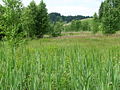
The Rottach flows out of the Schwarzenberger Weiher near the Wasenmühle in the municipality of Oy-Mittelberg and then runs in a shallow depression with mostly moist litter and moor meadows. As far as the Rottachsee, it flows in a south-westerly direction through a 3.7-kilometer-long initial section with a difference in altitude of only 16 meters, on which it crosses the A 7 next to the approximately five-hectare Rottachmoos nature reserve , a raised bog with rare, but for Allgäu raised bogs characteristic plants.
As part of the EU nature conservation legislation, the Obere Rottachtal is part of the FFH area of Kempter Wald with the Upper Rottachtal .
Rottachsee
The outflow of the Rottach from the reservoir is 3.5 kilometers in a straight line, measured behind its confluence with the lake. Before the construction of the reservoir, the Rottach flowed in this area in a widespread meander shape through detailed, species-rich forest and meadow landscape.
Lower Rottach Valley
After the Rottach has left the reservoir, the valley narrows noticeably until it merges into a gorge-like narrow point below Riedis, which is known as the Rottach Gorge . At the end of the Ice Age, meltwater was initially blocked from flowing through, so that a lake was formed. Over time, the water created the incision at the overflow point. Today the valley is mostly forested in this area and offers a wild and romantic sight. It is under landscape protection here. The Rottach flows into the Iller at Rottachmühle on the border between the communities of Sulzberg and Rettenberg . Since she left the lake, she has covered a distance of six kilometers and an altitude difference of 148 meters.

Upper course between Gschwend and Josereute
Upper Rottachtal

Rottachsee

Mouth of the Rottach into the Iller (on the right the different colored water of the Iller)
.JPG)


Individual evidence
- ↑ a b Height queried (with a right click) on: BayernAtlas of the Bavarian State Government ( information )
- ↑ a b Directory of the brook and river areas in Bavaria - Danube river area from source to Lech, page 13 of the Bavarian State Office for the Environment, as of 2016 (PDF; 2.3 MB)
- ^ Deutsches Gewässerkundliches Jahrbuch Danube region 2006 Bavarian State Office for the Environment, p. 105, accessed on October 4, 2017, at: bestellen.bayern.de (PDF, German, 24.2 MB).
- ^ Norbert Herrmann: Petersthal - history of an Allgäu community , Verlag für Heimatpflege, Kempten 1976