Kochelsee
| Kochelsee | ||
|---|---|---|

|
||
| Geographical location | Alpine foothills | |
| Tributaries |
Loisach , Walchensee power station , Haselrieslaine , Kohllaine , Lainbach , Heckenbach , Jochbach, smaller mountain streams |
|
| Drain | Loisach | |
| Places on the shore | Kochel , Schlehdorf | |
| Data | ||
| Coordinates | 47 ° 38 '46 " N , 11 ° 20' 14" E | |
|
|
||
| Altitude above sea level | 600 m above sea level NN | |
| surface | 5.95 km² | |
| length | 3.53 km | |
| width | 3.45 km | |
| volume | 0.184.7 km³ | |
| scope | 15 km | |
| Maximum depth | 65.9 m | |
| Middle deep | 31.0 m | |
| PH value | 8.2 | |
| Catchment area | 683.7 km² | |
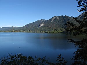
The Kochelsee is located 70 km south of Munich on the edge of the Bavarian Alps . It belongs to the communities Schlehdorf (around 30 percent) in the west and Kochel am See in the east. The lake is owned by the Free State of Bavaria and is administered by the Bavarian Administration of State Palaces, Gardens and Lakes .
Location and settlement history

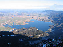
While the southern area of the lake is surrounded by mountains, the northern part is already in the flat foothills of the Alps and is bounded by the Loisach-Kochelsee moors. The history of the settlement of Kochel (formerly Quochcalun) began on the so-called Birg bei Altjoch, a rock cone directly on the shore of the Kochelsee. The name Kochel is derived from the Latin cocula, the name for head, cone or peak. Of the Romanic generic names, it is particularly the Kapf and Kogel with the subsidiary forms Kochel, Gugel, Kögel and Kegel that are common throughout the Bavarian language area ...
Emergence

The lake was created in the Würm by Ausschürfung the Isar-Loisach glacier . The subsoil of the resulting basin was then filled with sea clays from an Ice Age lake, which formed a damming subsoil. Today's Kochelsee is only a remnant of the approx. 200 m deep basin in the area of the flysch zone that originally reached as far as Penzberg . The lake gradually silted up so that the Loisach-Kochelsee moors with low and raised moors formed north of it .
Inflow and outflow
In Schlehdorf , north below Herzogstand and Heimgarten that flows Loisach in the western section of Kochel. It leaves the lake on its northern edge, west of Kochel am See .
At the same time, the same amount of water flows on average from the Walchensee - and thus from the Isar - through the Walchensee hydropower plant . In order to keep fluctuations in the water level low, the outflow is regulated by a canal sluice parallel to the natural outlet of the Kochelsee.
The dredging of the Loisach from 1901 to 1904 lowered the lake level by around 1.8 meters.
tourism
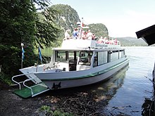
Due to its location at the foot of the Herzogstand and its proximity to the Walchensee , the Kochelsee plays a major role for tourism in the region. In addition to swimming, walking and boat trips, the region is ideal for hiking. There are also opportunities to ski down on the Herzogstand, from which you can see Kochelsee and Walchensee. The Kochel climbing area is well-known with difficult routes for sport climbers and for deep water soloing (climbing from the water).

The Kochelsee is also an area for windsurfers and kite surfers , which is known for frequent strong winds. When there is foehn in the Alps , the wind blows down the Kesselberg . On cold nights, downdraft winds can arise on the northern slope of the Herzogstand and Heimgarten, which last into the morning. Winds up to 8 Bft were measured.
Neighbors
The villages on the shores of the lake belong to the Bad Tölz-Wolfratshausen district and are:
- Kochel am See
- Schlehdorf
- Raut (west bank, district of Schlehdorf)
- Altjoch (south bank, district of Kochel am See)
See also
Web links
- The Kochelsee on the site of the bay. Lock management
- High resolution webcam from the Fahrenbergkopf to the Kochelsee
- Kochelsee on the community side
Individual evidence
- ↑ a b c d e f g Documentation of the condition and development of the most important lakes in Germany: Part 11 Bavaria (PDF; 1.7 MB)
- ↑ Philological folklore work or. Karl Vollmöller, published by F. Junge, 1908. Original from University of Michigan, ISBN 3-931516-09-1
- ↑ Hans Demleitner: Kochel a.See. May 1983, p. 211.
- ↑ Windsurfing on the Kochelsee


