
Giessenbach (Loisach)
| Giessenbach | ||
 Gießenbach catchment area |
||
| Data | ||
| Water code | DE : 16254 | |
| location | District of Garmisch-Partenkirchen , Upper Bavaria , Bavaria , Germany | |
| River system | Danube | |
| Drain over | Loisach → Isar → Danube → Black Sea | |
| origin | Roßalm 47 ° 32 '31 " N , 11 ° 2' 56" O |
|
| Source height | 1547 m above sea level NN | |
| muzzle | in the Loisach near Oberau Coordinates: 47 ° 34 '9 " N , 11 ° 8' 57" E 47 ° 34 '9 " N , 11 ° 8' 57" E |
|
| Mouth height | 648 m | |
| Height difference | 899 m | |
| Bottom slope | 10% | |
| length | 8.9 km | |
| Catchment area | 11.34 km² | |
| Communities | Oberau , Ettal , Farchant | |
 Giessenbach in Oberau |
||
The Gießenbach is a brook in the southeastern Ammergau Alps , which flows into the Loisach near Oberau as a left tributary .
Catchment area and course
The approx. 11 km² catchment area of the Gießenbach is framed in the north by the Notkarspitze , the Ziegelspitz and the Mühlberg, in the west by the Hasenjöchl and in the south by the Brünstelskopf , as well as the Schafkopf and Rabenkopf.
The Gießenbach arises below the Hasenjöchl in the area of the former Roßalm (also Gießenbachalm) and flows northeast through the Gießenbachtal. The upper course is located within the district of Farchant. Below the Roßalm up to the confluence of the Markgraben, the brook forms the municipal boundary between Oberau and Ettal. There are several sources in this section ("At the Sources"). At the point where the marrow ditch joins the Gießenbach bends to the east and enters the district of Oberau in the Untermberg district. A plant canal branches off there, which was used to generate electricity. Only 300 m after the reunification of Gießenbach and Werkkanal, another canal, the Mühlbach, branches off again. The Gießenbach continues to flow in a north-easterly direction through Oberau in a fortified channel and is accompanied by a footpath and bike path. About 500 m before crossing under the Bundesstraße 2 and the Werdenfelsbahn, a Trift Canal used to branch off , which led a little south of today's Gießenbach to the Loisach and whose traces are still visible in the area east of the railway line.
Geology and hydrology
The course of the Gießenbach stream is predominantly shaped by the main dolomite . Rocks from the Raibler strata also come to light only in short sections . The Gießenbach flows between the confluence of the Markgraben and Untermberg in a valley cut filled with loose rock, which in the Pleistocene was still used by the Ammer , which then flowed into the Loisach Valley. Only at the end of the Würm glacial period was this river course closed by a lateral moraine of the Loisach glacier . It is noteworthy that the Gießenbach has a higher discharge on average than the neighboring Lahnenwiesgraben , although the area of its catchment area only accounts for around 60% of the area of the Lahnenwiesgraben catchment area. The cause of this is suspected to be an underground tap in the catchment area of the Ammer.
The water-bearing loose rock in this section made driving conditions difficult and complex sealing measures during the construction of the Oberau bypass tunnel .
More photos
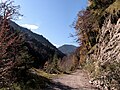
Giessenbachtal. In the background the Brünstelskopf.

Gießenbach above Untermberg.

The Giessenbach near Oberau. On the right a former turbine house.
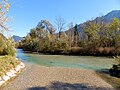
The mouth of the Gießenbach (from the front) into the Loisach (from the right).


_mit_Kraftwerk.jpg)

Web links
Individual evidence
- ↑ a b List of creek and river areas in Bavaria - Isar river area, page 19 of the Bavarian State Office for the Environment, as of 2016 (PDF; 2.5 MB)
- ↑ Official Topographic map 1: 25000, Oberammergau sheet, 1959 edition
- ↑ Explanations of the Geological Map of Bavaria, 1: 25000, Oberammergau sheet (distributed by the Bavarian State Office for the Environment)
- ↑ Merkur.de March 20, 2017