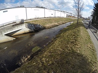
Säubach (Loisach)
|
Säubach Zeilbach |
||
|
Säubach in Penzberg |
||
| Data | ||
| location | Upper Bavaria | |
| River system | Danube | |
| Drain over | Loisach → Isar → Danube → Black Sea | |
| Source height | 606 m | |
| muzzle |
Loisach coordinates: 47 ° 45 ′ 37 ″ N , 11 ° 24 ′ 38 ″ E 47 ° 45 ′ 37 ″ N , 11 ° 24 ′ 38 ″ E |
|
| Mouth height | approx. 584 m | |
| Height difference | approx. 22 m | |
| Bottom slope | approx. 2.8 ‰ | |
| length | approx. 8 km | |
| Right tributaries | Swather ditch | |
The Säubach , called the Zeilbach in the upper reaches , is a left tributary of the Loisach near Penzberg in the Upper Bavarian district of Weilheim-Schongau .
It consists of a widely branched network of tributaries and has an irregular, largely eastward course, limited to the south of Penzberg and in Penzberg's urban area. Flood protection is also discussed there.
Part of the stream runs in the FFH area Moore around Penzberg .
Individual evidence
- ↑ Wolfgang Schörner: Flood: Is the protection in Penzberg still sufficient? In: Merkur.de. June 19, 2016. Retrieved March 19, 2018 .
- ^ Moors around Penzberg. In: protectedplanet.net. Retrieved March 19, 2018 .
