
Ramsach (Loisach)
|
Ramsach upper course: Laberlaine |
||
 Ramsach catchment area (shaded) |
||
| Data | ||
| Water code | EN : 1626 | |
| location | Upper Bavaria | |
| River system | Danube | |
| Drain over | Loisach → Isar → Danube → Black Sea | |
| source |
Ammergau Alps near Oberau 47 ° 34 ′ 25 ″ N , 11 ° 7 ′ 24 ″ E |
|
| Source height | 1181 m | |
| muzzle | in the Loisach near Murnau am Staffelsee Coordinates: 47 ° 40 '3 " N , 11 ° 13' 42" E 47 ° 40 '3 " N , 11 ° 13' 42" E |
|
| Mouth height | approx. 619 m | |
| Height difference | approx. 562 m | |
| Bottom slope | approx. 30 ‰ | |
| length | approx. 18.6 km | |
| Catchment area | 90.3 km² | |
| Left tributaries | Rautlaine , Ommilaine , Lindenbach | |
| Right tributaries | Auer Laine , Krebsbach , Rechtach | |
| Communities | Schwaigen , Murnau am Staffelsee | |
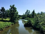
.jpg) Ramsach in Schwaiger Moos |
||
The Ramsach (formerly also Ramsau , Oberlauf: Laberlaine ) is a left tributary to the Loisach in Upper Bavaria .
structure
course
From the confluence of the Laberlaine with the Auer Laine near the hamlet of Höllenstein , the body of water is called Ramsach . She steps out of her Alpental and flows from here more or less north by the south-western parts of the Eschenloher Moos (Obermoos, Schwaiger moss), then flows hard left hand to the group of hills stone simmer over and then between the vertically running towards them wooded hill trains long simmer and Wiesmahdköchel (orographic left) and Steinköchel, Weghausköchel and Schmatzerlköchel (orographic right) through.
The Ramsach then crosses the Murnauer Moos . The course of the river Ramsach was changed several times by interventions. In the past, part of the water was diverted into several ditches (such as the Neue Ramsach with the lower course of the Schlechtengraben). Today most of the water flows through ditches, some of which are lake-like extensions, eastward into the Rechtach , which has accompanied them since Steinköchel in less than two kilometers beyond the groups of hills on the right.
The Lindenbach , which flows from Bad Kohlgrub into the Murnauer Moos, changes its name to Ramsach from the place where it formerly flows into the Ramsach. After the Murnau hamlet of Mühlhabing, the Schlechtengraben flows into this now east-south-east flowing Ramsach, and further down before Hechendorf the Rechtach, which thus also supplies most of the water from the upper reaches of the "upper" Ramsach.
Opposite the southern tip of Hechendorf, Loisachwasser feeds the Ramsach, which is diverted from the river about 1.5 km south at a weir. The Ramsach then runs a few kilometers northeast and parallel to the Loisach, into which it joins from the left at Achrain. Most of the water, however, is branched off into the Mühlbach shortly before Mühlhagen , which also flows into the Loisach after just under 1 km.
Catchment area
The Ramsach drains an area of 90.3 km², including almost all of the Murnauer Moos, the Eschenloher Moos and the north-eastern flanks of the Ammergau Alps .
More photos

Laberlaine waterfall.
Ramsach in Murnau-Hechendorf. In the background the confluence of the Loisach Canal (from the right).

The Ramsach (Mühlbach) flows into the Loisach (left).


Individual evidence
- ↑ Catchment area according to: Directory of stream and river areas in Bavaria - Isar river area, page 21 of the Bavarian State Office for the Environment, as of 2016 (PDF; 2.5 MB), accessed on August 30, 2019.