Rear crack
|
Hinterriß ( village ) locality |
||
|---|---|---|
|
|
||
| Basic data | ||
| Pole. District , state | Schwaz (SZ), Tyrol | |
| Judicial district | black | |
| Pole. local community | Vomp ( KG Vomp) | |
| Coordinates | 47 ° 28 '23 " N , 11 ° 28' 0" E | |
| height | 928 m above sea level A. | |
| Residents of the village | 27 (January 1, 2020) | |
| Building status | 27 (January 1, 2015) | |
| Post Code | 6215 Achenkirch | |
| prefix | + 43/5245 (rear crack) | |
| Statistical identification | ||
| Locality code | 17045 | |
| Counting district / district | Vomp (70 936 000) | |
| Source: STAT : index of places ; BEV : GEONAM ; TIRIS | ||
|
Hinterriß ( Rotte ) village |
|
|---|---|
| Basic data | |
| Pole. District , state | Schwaz (SZ), Tyrol |
| Judicial district | black |
| Pole. local community | Eben am Achensee ( KG Eben) |
| Coordinates | 47 ° 28 ′ 23 " N , 11 ° 28 ′ 0" E |
| height | 928 m above sea level A. |
| Residents of the village | 5 (January 1, 2020) |
| Building status | 18 (January 1, 2015) |
| Post Code | 6215 Achenkirch |
| prefix | + 43/5245 (rear crack) |
| Statistical identification | |
| Locality code | 16996 |
| Counting district / district | Eben am Achensee (70907 000) |
| Source: STAT : index of places ; BEV : GEONAM ; TIRIS | |
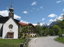
Hinterriß is a village in Tyrol and the only permanent settlement within the Karwendel . Politically, it is divided and assigned to two municipalities , whose core locations are on the south and east of this mountain group. The part to the west of the Rissbach belongs to the market town of Vomp , the part to the east of the brook to the town of Eben am Achensee . There is no direct road connection to Vomp and Eben. With a straight line distance between Hinterriß and the village of Vomp of 21 kilometers, the road distance that leads via Achenkirch is 65 km.
geography
Hinterriß lies at 928 m above sea level. A. approximately in the middle of the rift valley . Its innermost part, the Eng , is located in the southeastern quarter of the Karwendel Mountains at the western foot of the Sonnjoch Group . At the northern edge of the mountains the valley at Vorderriß connects to the Isarwinkel , a section of the Isar valley . Since Vorderriß is in Germany and there is no pass road over the Karwendel Mountains, Hinterriß is a functional enclave. In contrast to similar functional and geographical enclaves , such as the Kleinwalsertal or Jungholz , Hinterriß is not a customs connection area to Germany. The surrounding mountains have peak heights of almost 1500 to over 2000 meters. Its slopes are mostly covered with forest up to the tree line. The meadows in the narrow valley together cover less than a square kilometer. The Almdorf Eng is located twelve kilometers into the valley in the Großer Ahornboden .
history
In the 16th century the Riss valley gained importance as a hunting and forest area. Already in 1484 iron ore deposits were discovered, mined which since then and on site in a smelter were smelted. In 1544 the mining industry came into the possession of the Fuggers .
The miners built a small chapel "Maria auf der Schmelz", which over time became the goal of a lively pilgrimage, especially from the Bavarian region. Hinterriß belonged to the Diocese of Freising until 1822 and only then came to the Diocese of Brixen . At the request of the Brixen Ordinariate, Franciscans from the Schwaz monastery initially took over pastoral care on a temporary basis. In 1831 they took over the branch with two fathers and a lay brother. The settlement at that time consisted of a church and widum including a stable and barn as well as a forester's house and individual scattered buildings and alpine pastures in the area.
Tourism began in the middle of the 19th century. Prince Karl zu Leiningen had the roads to Hinterriß renewed and a hunting lodge built near the church, which was taken over in 1859 by Ernst II of Saxe-Coburg and Gotha .
population
According to the 2001 census, 41 residents lived in the district of Vomp and 13 in the district of Eben. In 2010 three buildings (two residents) were reclassified from the municipality of Eben to the municipality of Vomp.
In 2015, 34 residents were registered in the Vomper part and 7 in the flat part (as of January 1, 2015).
traffic
Hinterriß can be reached all year round on a toll-free road from Vorderriß in Bavaria (district road TÖL 24 in Bavaria, Rissalstrasse L 282 in Tyrol). Since the road connections to the core towns of the municipalities run along this road and further east around the mountains, the distance to Eben is 52 km and that to Vomp 65 km.
From Hinterriß a toll road (closed in winter) leads another 14 km into the valley to the Eng .
In summer, a bus runs from Lenggries in Bavaria to Eng. This "Bergsteigerbus" is operated in cooperation between the RVO and the Munich and Oberland sections of the German Alpine Club.
church
In Hinterriß there is a small church of Mariä Schmelz / To Our Lady of the Visitation of Our Lady, assigned to the parish of Achenkirch . Pilgrimage services are held here several times a year. There is a patronage, a blessing of the sick and animals, a motorcycle and bicycle blessing and a car service.
economy
In economic terms, Hinterriß depends mainly on tourism in addition to forestry and hunting . Accommodation is available. a. in the Gasthof zur Post and in the Café Klösterle Hinterriß .
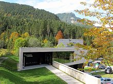
In tourism advertising, the area is summarized under the name Hinterriß-Eng . Hikers, mountain bikers and, in winter, skiers (cross-country and touring skis) can be found here. On June 6, 2009 the newly built nature park house was inaugurated as the information center for the Karwendel Alpine Park.
Hinterriß has its own telephone area code (05245), but belongs to Achenkirch (postal code 6215) for postal traffic.
Web links
- Nature Park House in Hinterriß at www.karwendel.org
Individual evidence
- ↑ Robert R. v. Srbik: Overview of mining in Tyrol and Vorarlberg in the past and present. In: Reports of the Natural Science and Medical Association in Innsbruck, Volume 41 (1929), pp. 113–279 ( PDF; 7.2 MB )
- ↑ a b Pascal M. Hollaus: The little monastery in the Karwendel. The visitors of the Franciscan exposition in Hinterriß. In: Austria franciscana No. 5 (2010), pp. 78–85 ( PDF; 391 kB )
- ^ Announcement of the state government of July 12, 2010 on the approval of a change in the municipal boundary between the municipalities of Eben am Achensee and Vomp. Provincial Law Gazette for Tyrol, No. 45/2010 ( PDF; 129 kB )
- ↑ residents by locality (Excel file, 766 kB); Retrieved July 29, 2015


