Eng (municipality of Vomp)
| Narrow ( Scattered Houses ) | ||
|---|---|---|
|
|
||
| Basic data | ||
| Pole. District , state | Schwaz (SZ), Tyrol | |
| Judicial district | black | |
| Pole. local community | Vomp ( KG Vomp) | |
| Locality | Rear crack | |
| Coordinates | 47 ° 23 '56 " N , 11 ° 33' 29" E | |
| height | 1227 m above sea level A. | |
| Statistical identification | ||
| Counting district / district | Vomp (70 936 000) | |
| Source: STAT : index of places ; BEV : GEONAM ; TIRIS | ||
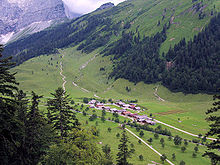
Eng (officially Alpe Eng ) is an alpine village and tourist resort in the market town of Vomp im Karwendel in the Austrian state of Tyrol .
geography
The village is located in the Tyrolean Alpine Park Karwendel approx. 12 km southeast of the village of Hinterriß , which belongs to the market town of Vomp , at the end of the Riss valley in the Großer Ahornboden . The Eng lies at 1227 m above sea level. A. and has a total area of 510 hectares. The Alm can only be approached from the north of Bavaria via a toll road (Hinterriß ↔ Eng) because it is surrounded on three sides by mountains . In winter the driveway is closed, the village is uninhabited and should not be entered by hikers and ski tourers due to the danger of avalanches .
history
A bronze sword found at Hinterriß suggests that people roamed this remote valley as early as the Bronze Age. Mentions in various old documents suggest that people settled on the alpine pastures as early as 1000 years ago. The first written record dates back to 1523. Since then, the Eng has been managed continuously.
Only during the Thirty Years War was the Alm unused for a few years. Most of the old maple trees that can be found in the valley today date from this period. The trees only had the opportunity to grow tall without being grazed again during those years when there was no alpine pasture. When the cattle were driven back into this alpine valley after the war, the trees were already too big to be eaten and have been preserved to this day as a stock of trees of about the same age.
The small wooden alpine chapel, in which services and sometimes even weddings are still held today, dates from around 1700 .
In the middle of the 19th century, the owners of the Alm, farmers from the area around Schwaz , founded an agricultural community that today consists of ten farmers.
Since 1941, the Engalm has been supplied with drinking water by installing a spring and building a water pipe.
tourism
The toll road originally laid out for alpine operations is used by many day vacationers from the greater Munich area and the Munich Oberland to drive into the Karwendel Nature Park by car or motorcycle. As a result, the Eng has developed into a tourist center with a large restaurant and large parking lot, 500 meters from the Almdorf.
In winter the road into the Eng is closed.
The dairy, built in 1883, was rebuilt in 1995 and again in 2006. In 2006 it was fitted with a cheese maker and large windows were built in so you can watch the cheesemakers at work.
The following long-distance hiking trails lead across the Eng : the Via Alpina , the Adlerweg , the European long-distance hiking trail E4 and the Nordalpenweg 01 .
Web links
- Official website of the tourism association about the Karwendel and Eng
- Current information about the Ahornboden, the Eng and the Engalm
Individual evidence
- ↑ Back then. Agricultural community Engalm, accessed on August 15, 2020 .
- ^ Homepage of Eng , accessed on January 17, 2013.


