Gleirsch-Halltal chain
| Gleirsch-Halltal chain | ||
|---|---|---|
|
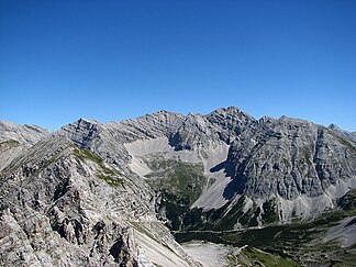
The Praxmarerkar peaks from the Nordkette |
||
| Highest peak | Big begging throw ( 2726 m above sea level ) | |
| location | Tyrol , Austria | |
| part of | Karwendels | |
|
|
||
| Coordinates | 47 ° 21 ' N , 11 ° 26' E | |
| surface | 117.7 km² | |
|
The Sonntagkar from the Mandlspitze (Nordkette) |
||
|
The Barthgrat between the Großer Katzenkopf and the Mittlerer Jägerkarspitze, named after Hermann von Barth , the "developer of the Karwendel" |
||
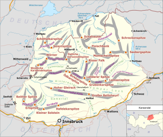
The Gleirsch-Halltal -kette is a chain of the Karwendel in the Northern Limestone Alps . It follows the Hinterautal-Vomper chain to the south , the longest mountain range in the Karwendel, and is almost as powerful as it. South of the Stempeljochspitze , it connects to the Nordkette via the Stempeljoch ( 2215 m above sea level ) . The name of the mountain range is derived from the following two valleys: the Gleirschtal in the west or south-west and the Halltal in the south-east.
Its highest peak is the Großer Bettelwurf ( 2726 m above sea level ), which rises 2200 m over the Inn Valley . Other well-known peaks are the two cornerstones of the Lafatscher Joch ( 2081 m above sea level ), which forms the only transition from the Hinterautal to the Halltal : the Speckkarspitze , the Kleine Lafatscher with the famous intersection and the Große Lafatscher . From Scharnitz you can easily reach the western cornerstone of the chain, the Hohe Gleirsch , through the Gleirschtal. The summits in the middle part of the Gleirsch-Halltal chain between Möslalm and Pfeishütte (Jägerkarspitzen, Praxmarerkarspitzen, Kaskarspitze, Sonntagkarspitze, Hintere Bachofenspitze) are difficult to reach, partly pathless and with easy climbing on the not always solid rock.
In the Gleirsch-Halltal chain, too, the steep rock breaks typical of the four large Karwendel chains can be seen to the north, some of which drop several hundred meters vertically. All noteworthy peaks are formed from Wetterstein limestone, which was mainly formed in the Middle Triassic in lagoons and reef areas. Only the very eastern Walder Joch ( 1636 m above sea level ) consists of Jurassic limestone and main dolomite .
Important peaks (following the course of the mountain range from west to east)
- Hoher Gleirsch ( 2492 m above sea level )
- Upper Sagkopf ( 2154 m above sea level )
- Big cat's head ( 2531 m above sea level )
- Outer Riegelkarspitze ( 2407 m above sea level )
- Inner Riegelkarspitze ( 2438 m above sea level )
- Middle Jägerkarspitze ( 2608 m above sea level )
- Hinterödkopf ( 2453 m above sea level )
- Jägerkarlspitze ( 2470 m above sea level )
- Western Praxmarerkarspitze ( 2642 m above sea level )
- Eastern Praxmarerkarspitze ( 2638 m above sea level )
- Kaskarspitze ( 2580 m above sea level )
- Sonntagkarspitze ( 2575 m above sea level )
- Rear Bachofenspitze ( 2668 m above sea level )
- Vordere Bachofenspitze ( 2663 m above sea level )
- Rosskopf ( 2670 m above sea level )
- Stempeljochspitze ( 2543 m above sea level )
- Großer Lafatscher ( 2696 m above sea level )
- Kleiner Lafatscher ( 2636 m above sea level )
- Speckkarspitze ( 2621 m above sea level )
- Signal head ( 2504 m above sea level )
- Small begging throw ( 2650 m above sea level )
- Big begging throw ( 2726 m above sea level )
- Hohe Fürleg ( 2570 m above sea level )
- Hundskopf ( 2243 m above sea level )
- Walder Joch ( 1636 m above sea level )
Web links
- On the nomenclature of the Hallthal chain. : Journal of the German Alpine Association / Journal of the German and (the) Austrian Alpine Association , year 1879, pp. 149–165 (online at ANNO ).


