Inntal chain
| Inntal chain (Nordkette) | ||
|---|---|---|
|
The north chain from the Mandlspitze, view to the west |
||
| Highest peak | Kleiner Solstein ( 2637 m above sea level ) | |
| location | Tyrol , Austria | |
| part of | Karwendels | |
|
|
||
| Coordinates | 47 ° 18 ′ N , 11 ° 21 ′ E | |
| surface | 130.8 km² | |
|
The Hafelekarhaus of the Nordkettenbahn |
||
|
The western flank of the Rumerspitze |
||
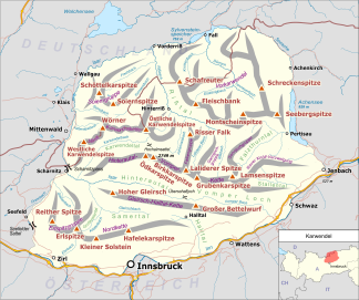
The Inntal range , known as the Nordkette because of its location north of Innsbruck and in common parlance , is the southernmost and shortest of the four large mountain ranges in the Karwendel . In the west it connects to the Erlspitz group via the Erlsattel , in the east via the Stempeljoch ( 2215 m above sea level ) to the Gleirsch-Halltal chain . In the south it borders on the Inn Valley . The highest peak is the Kleine Solstein ( 2637 m above sea level ) in the west of the mountain range.
The Nordkette is accessed via the Nordkettenbahn , which offers easy access to the ski area and the Innsbruck via ferrata , which starts in the east near the Hafelekarhaus station ( 2269 m above sea level ) of the Nordkettenbahn via the Seegrubenspitze ( 2350 m above sea level). ), which Kemacher and Langen Sattel lead to Frau Hitt and Frau Hitt-Sattel in the west. Furthermore, the Goetheweg leads from the Hafelekarhaus along the ridge to the east to the Pfeishütte north of the Rumer Spitze . The Nordkette single trail , one of the most demanding routes in Europe for freeride mountain bikers, runs below the Hungerburg - Seegrube section of the Nordkettenbahn .
The following Alpine Club huts are ideal for mountaineers as bases for multi-day tours and for many summit ascents in the Nordkette range: the Solsteinhaus , the Neue Magdeburger Hütte , the Pfeishütte and the Bettelwurfhütte in the Gleirsch-Halltal chain.
In the southwest of North chain is preceded by a small mountain range of Hechenberg to said Kirchbergköpfl an altitude of 1943 m above sea level. A. and is separated from the Nordkette to the northeast and east by the Kranebitter Gorge .
Important peaks (following the course of the mountain range from west to east)
- Großer Solstein ( 2541 m above sea level )
- Kleiner Solstein ( 2637 m above sea level )
- Hohe Warte ( 2597 m above sea level )
- Hippenspitze ( 2388 m above sea level )
- Hintere Brandjochspitze ( 2599 m above sea level )
- Vordere Brandjochspitze ( 2559 m above sea level )
- Brandjochkreuz ( 2268 m above sea level )
- Frau Hitt ( 2270 m above sea level )
- Western Sattelspitze ( 2339 m above sea level )
- Eastern Sattelspitze ( 2369 m above sea level )
- Kemacher ( 2480 m above sea level )
- Western fireplace peak ( 2445 m above sea level. A. )
- Middle chimney top ( 2435 m above sea level )
- Eastern Kaminspitze ( 2435 m above sea level )
- Seegrubenspitze ( 2350 m above sea level )
- Hafelekarspitze ( 2334 m above sea level )
- Gleirschspitze ( 2317 m above sea level )
- Mandlspitze ( 2366 m above sea level )
- Gleirschtaler Brandjoch ( 2372 m above sea level )
- Rumerspitze ( 2454 m above sea level )
- Thaurer Jochspitze ( 2306 m above sea level )
- Pfeiserspitze ( 2347 m above sea level )
- Lattenspitze ( 2330 m above sea level )
- Wildangerspitze ( 2153 m above sea level )
- Thaurer Zunterkopf ( 1918 m above sea level )
- Haller Zunterkopf ( 1966 m above sea level )
- Hochmahdkopf ( 1738 m above sea level )


