Rumer tip
| Rumer tip | ||
|---|---|---|
|
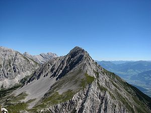
The western flank of the Rumerspitze |
||
| height | 2454 m above sea level A. | |
| location | North of Innsbruck | |
| Mountains | Nordkette , Karwendel | |
| Dominance | 1.7 km → Stempeljochspitze | |
| Notch height | 296 m ↓ Arzler Scharte | |
| Coordinates | 47 ° 19 '13 " N , 11 ° 25' 33" E | |
|
|
||
| rock | Wetterstein lime | |
| Age of the rock | Triad | |
| First ascent | 1867 by Julius Pock | |
| Normal way | West ridge, UIAA II | |
|
The Rumer Spitze from the east |
||
The Rumer peak is a 2454 m above sea level. A. high mountain in the north chain in the Karwendel in Tyrol. It is one of the highest peaks in the eastern northern chain and is popular because of its view over the Inn Valley and the city of Innsbruck .
location
The Rumer Spitze rises in the north of the market town of Rum and the Innsbruck district of Arzl . To the west is the Arzler Scharte ( 2158 m above sea level ), the transition to the Mandlspitze ( 2366 m above sea level ) and to the Gleirschtaler Brandjoch ( 2372 m above sea level ); east of the Kreuzjöchl ( 2121 m above sea level ), the transition to 2306 m above sea level. A. high Thaurer Jochspitze. North of the mountain is the Pfeis , the valley of Samertals .
The southern flank of Rumer peak is steep grassy slopes and craggy dominated, while the north side has the character of a platy rock wall.
Routes to the summit
The most important route to the Rumer Spitze is the pronounced west ridge ( UIAA II ) running from the Arzler Scharte to the summit . This route is popular on the one hand because it can be reached from the Hafelekar station of the Nordkettenbahn with a relatively small difference in altitude, and on the other hand because the scree slope that descends from the Arzler Scharte ( Arzler Reise ) enables a direct descent to Innsbruck. Another path (UIAA I) leads from Kreuzjöchl in the east to the summit. The pathless route through the Alblehner avalanche ditch over the southern flank and the southern ridge (UIAA II-) is rarely chosen in summer, but can be done as a ski tour in spring .
The bases at the Rumer Spitze are in the south the Enzianhütte ( 1041 m above sea level ), the Rumer Alm ( 1243 m above sea level ) and the Thaurer Alm ( 1464 m above sea level ), in the north the Pfeishütte ( 1922 m above sea level ) o. A. ). There is a small bivouac box on the southern flank .
Further views of the Rumer Spitze
The Rumer Spitze of Innsbruck. In the foreground the Olympic village and Arzl
literature
Walter Klier: Alpine Club Guide Karwendel alpine . 14th edition. Bergverlag Rudolf Rother, Munich 1996, ISBN 3-7633-1121-1 .


