Stamp yoke tip
| Large stamp yoke tip | ||
|---|---|---|
|
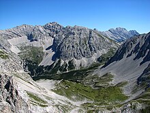
The Große Stempeljochspitze to the left of the center, to the right the more striking Rosskopf , from the east ( Halltal ) |
||
| height | 2543 m above sea level A. | |
| location | Tyrol , Austria | |
| Mountains | Gleirsch-Halltal chain , Karwendel | |
| Dominance | 0.42 km → Rosskopf | |
| Notch height | 52 m ↓ notch to Rosskopf | |
| Coordinates | 47 ° 20 '5 " N , 11 ° 26' 18" E | |
|
|
||
| Normal way | from the Stempeljoch over the south ridge ( UIAA I ) | |
The Stempeljochspitze , also in the plural Stempeljochspitzen , is 2543 m above sea level. A. high mountain in the Gleirsch-Halltal chain in the Karwendel in Tyrol .
Location and surroundings
The Stempeljochspitzen are north of the 2215 m above sea level. A. high Stempeljoch , which connects the Gleirsch-Halltal chain with the Nordkette . The Great Stempeljochspitze reaches 2543 m above sea level. A. and has a rather rocky character, while the Kleine Stempeljochspitze ( 2539 m above sea level ), about 200 meters southwest , which also carries the summit cross , slopes down towards the Stempeljoch with a broad, grassy south ridge ( Holzlege ).
Ascent
The normal route leads from the Stempeljoch, which can be reached from the Arzler Scharte or from the Goetheweg via the Pfeishütte ( 1922 m above sea level ), over the broad south ridge to the small one in about an hour and from there in easy climbing ( difficulty level I (UIAA) ) to the large Stempeljochspitze. This climb is also a popular ski tour . On the west and east side, several climbing routes of difficulty levels II to VI- lead to the Stempeljochspitzen.
Web links
Individual evidence
- ^ Austrian map 1: 50,000, AMAP Online. Federal Office for Metrology and Surveying
- ↑ a b Alpine Club Map No. 5/2 Karwendel Mountains Middle, 2003
- ↑ a b Heinrich Klier , Fritz March: Alpine Club Guide Karwendel Mountains . Ed .: German Alpine Association , Austrian Alpine Association , Alpine Association South Tyrol . 11th edition. Bergverlag Rother, Munich 1978, ISBN 3-7633-1208-0 , p. 238-240, RZ 601-608 .
- ^ Heinrich Klier, Fritz March: Alpine Club Guide Karwendel Mountains . 12th edition. Verlag Rudolf Rother, Munich 1984, ISBN 3-7633-1200-5 , RZ 1020.


