
Little Solstein
| Little Solstein | ||
|---|---|---|
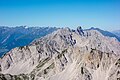
 From left to right: Hintere Brandjochspitze , Hohe Warte , Kleiner Solstein, Großer Solstein . Taken from the Reither Spitze (from west-northwest) |
||
| height | 2637 m above sea level A. | |
| location | Tyrol , Austria | |
| Mountains | Nordkette , Karwendel | |
| Dominance | 8 km → Western Praxmarerkarspitze | |
| Notch height | 516 m ↓ Kreuzjöchl | |
| Coordinates | 47 ° 18 '7 " N , 11 ° 19' 27" E | |
|
||
| rock | Wetterstein lime | |
| Age of the rock | Triad | |
| First ascent | 1867 by Pock , Wechner, Angermaier | |
| Normal way | Rise from the west | |
| particularities | Highest peak in the Nordkette | |

The Kleine Solstein is a 2637 m above sea level. A. high mountain in the north chain in the Karwendel in Tyrol . Despite its name, it towers over the neighboring Großer Solstein ( 2541 m above sea level ) by almost 100 meters, making it the highest peak in the northern chain. The south side of the Kleiner Solstein, facing the Inn Valley, is characterized by craggy and steep Karen, to the north it falls in a wall up to 600 meters high in the direction of Großkristental , which runs from the Gleirschtal in a south-westerly direction to the Erlsattel .
Climbs
The normal route on the Kleine Solstein leads from the saddle between the Großem and Kleiner Solstein, first crossing a small rock ridge, then via Schrofen from the south to the flat summit ridge, ascending as a marked trail to the summit. The way to the saddle between the peaks can be reached either via the Solsteinhaus and the Großer Solstein or on two steep slopes from the south from the Neue Magdeburger Hütte .
The transition from the Hohe Warte to the east of the Gamswartsattel has the difficulty UIAA III and leads directly over the initially extremely sharp east ridge. Several difficult climbing routes lead through the north face .
photos

Small (left) + large (right) Solstein with Solsteinhaus from NW

Small (left) + large (right) Solstein by N
View of the Nordkette from the Stempeljochspitze, the Kleine Solstein looming prominently


literature
- Walter Klier: Alpine Club Guide Karwendel alpine . 14th edition. Bergverlag Rudolf Rother, Munich 1996, ISBN 3-7633-1121-1 .
Web links
Individual evidence
- ↑ Geological map of Bavaria with explanations (1: 500,000). Bavarian Geological State Office, 1998.