
Gleirschtal (Karwendel)
| Gleirschtal | ||
|---|---|---|
 In the Gleirschtal, view of the Nordkette |
||
| location | Tyrol , Austria | |
| Waters | Gleirschbach | |
| Mountains | Karwendel | |
| Geographical location | 47 ° 21 '10 " N , 11 ° 19' 16" E | |
|
||

The Gleirschtal is a side valley of the Hinterautal in the Karwendel , which is bordered in the west by the Erlspitz group , in the east and in the north by the Gleirsch-Halltal chain and in the south by the Nordkette .
The Gleirsch-Halltal chain, one of the four large mountain ranges in the Karwendel, is based on a tradition established by the "developer of the Karwendel" Hermann von Barth , according to which the mountain ranges are named after the valley districts located in the south, after the partly in the southwest of the Gleirschtal or Halltal .
The valley is crossed by the Gleirschbach flowing to the northwest , which flows north of the Gleirschklamm into the Isar coming from the Hinterautal .
bases
In the Gleirschtal is the Möslalm ( 1262 m above sea level ), which offers itself as a base for touring destinations in the Erlspitz group, the peaks of the western Gleirsch-Halltal chain and the Nordkette.
Tour possibilities
The route is closed to public traffic. The Gleirschtal is popular with mountain bikers who choose either the Möslalm as the destination for their tours or the Pfeishütte ( 1922 m above sea level ) after an ascent through the Samertal to the south-east .

In the Gleirschtal, looking south
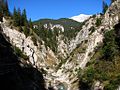
The Gleirschbach in the Gleirschklamm

