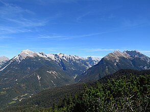
Hinterautal
| Hinterautal | ||
|---|---|---|
|
The Hinterautal from the west, on the left the Hinterautal-Vomper chain, on the right the Hohe Gleirsch in the Gleirsch-Halltal chain |
||
| location | Tyrol , Austria | |
| Waters | Isar | |
| Mountains | Karwendel | |
| Geographical location | 47 ° 23 ' N , 11 ° 22' E | |
|
|
||
| height | 1500 to 970 m above sea level A. | |
| length | 14 km | |
The Hinterautal is a valley crossing the Karwendel from west to east, through which the Isar flows and in which the Isar springs are located.
The Hinterautal extends from Scharnitz to the eastern end of the valley, called Rossloch , over a length of approx. 14 km. Starting from Scharnitz, the valley is initially limited to a few kilometers to the north by the Northern Karwendel range , then interrupted by the Karwendel valley with the Karwendelbach flowing towards the Isar and further east by the Hinterautal-Vomper range . The Gleirsch-Halltal chain forms the southern boundary .
Coming from the west, the valley between the Scharnitzer Alm and the confluence of the Gleirschbach is deeply cut by the Isar. Then the valley stretches with a slight incline and without deep cuts to the source of the Isar and to the Kastenalm ( 1220 m above sea level ). The valley ends after a few kilometers in the Rossloch.
bases
Apart from the Scharnitzer Alm and the Wiesenhof ( 1036 m above sea level ) a few kilometers east of Scharnitz, there are no managed huts or accommodations until the end of the valley at the Kastenalm. At the end of the valley, the next overnight stay is in the Hallerangerhaus . All other transitions to the north or south have at least the character of mountain tours.
Tour possibilities
The valley is closed to public traffic. Due to the length of the valley and the moderate incline, the path from Scharnitz to the Kastenalm is a classic mountain bike tour. The valley is part of the approach to numerous peaks in the Hinterautal-Vomper chain, e.g. B. the southern approach to the Birkkarspitze . Here too, the first part of the route is typically covered by mountain bike.
The Isar in the Hinterautal can also be traveled by canoe.


