Northern Karwendel range
| Northern Karwendel range | ||
|---|---|---|
|
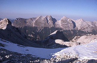
The northern Karwendel range with Bäralplkopf, Schlichtenkarspitze, Vogelkarspitze, Eastern Karwendelspitze, Grabenkarspitze, Lackenkarkopf and Kuhkopf (from the south from the Seekarscharte in the Hinterautal-Vomper range) |
||
| Highest peak | Eastern Karwendelspitze ( 2537 m above sea level ) | |
| location | Tyrol , Austria / Bavaria , Germany | |
| part of | Karwendels | |
|
|
||
| Coordinates | 47 ° 27 ' N , 11 ° 22' E | |
|
Hochkarspitze (left) and Wörner from the north |
||
|
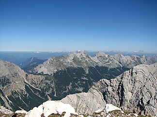
The northern Karwendel chain from Bäralpl to the Kuhkopf from the Pleisenspitze in the Hinterautal-Vomper chain |
||
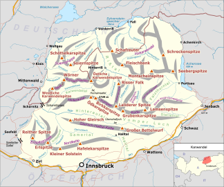
The northern Karwendel range is the northernmost of the four large mountain ranges in the Karwendel, which run parallel in large sections . It consists of very pure Wetterstein limestone , which has its main distribution in the Karwendel, and runs for a total length of approx. 18 km from Scharnitz in a north-easterly direction via Mittenwald to Wörner , where it bends sharply to the east until it finally ends west of the Johannestal . It has 25 main peaks with an average height of 2400 m . The highest peak is the Eastern Karwendelspitze ( 2537 m above sea level ). The border between Austria / Tyrol and Germany / Bavaria runs along the ridge from the Brunnensteinspitze in the west to the Eastern Karwendelspitze in the east. The north-west side is Bavarian, the south-east flank Tyrolean. The northern Karwendel chain must not be confused with the southernmost Karwendel chain, the Inntal chain, which is commonly referred to as the northern chain due to its location north of Innsbruck .
The southwestern part is strongly divided into side ridges by Kare (most clearly in Dammkar ), while the eastern part is a much more uniform rock face. Slightly to the east of its center, the chain is interrupted by a very pronounced, approx. 1 km wide and 500 m deep saddle, the Bäralpl , a wide plateau which is the only easy transition from the Soiern group north of the mountain range to the Karwendel valley and the next Karwendel chain, the Hinterautal-Vomper chain . The Gjaidsteig runs in the German section from Mittenwald to the Hochlandhütte ; From there the path leads north below the rock faces of Wörner and Hochkarspitze via Bäralpl to the Austrian south side of the Northern Karwendel range and further below Bäralplkopf ( 2323 m above sea level ), Vogelkarspitze and Eastern Karwendelspitze to the Karwendelhaus . The striking pair of peaks of the Eastern Karwendelspitze and the Vogelkarspitze can be seen with the naked eye from Munich and the foothills of the Alps . In general, the height of the chain increases gradually from the southwest to the culmination point in the east, the Eastern Karwendelspitze, only to drop rapidly from there.
The south-western part of the chain is well developed with numerous trails and is well attended due to its proximity to the valley towns of Mittenwald and Scharnitz. Particularly popular are the promising ridge crossing on the Mittenwalder Höhenweg , the western Karwendelspitze (the mountain station of the Karwendelbahn is just below the summit), the Wörner (climbing up to II, but well marked) and the eastern Karwendelspitze (because of its proximity to the Karwendelhaus). The remaining peaks, especially east of the Wörner, are rarely climbed due to the very long approach through the Johannes or Karwendel valleys and / or the lack of a path or difficult rocky terrain.
Important peaks (following the course of the mountain range from west to northeast or east)
- Brunnensteinspitze ( 2180 m above sea level )
- Rotwandlspitze ( 2191 m above sea level )
- Kirchlspitze ( 2301 m above sea level )
- Sulzleklammspitze ( 2321 m above sea level )
- Southern Linderspitze ( 2305 m above sea level )
- Gerberkreuz ( 2305 m above sea level )
- Northern Linderspitze ( 2372 m above sea level )
- Viererspitze ( 2054 m above sea level )
- Western Karwendelspitze ( 2385 m above sea level )
- Western Larchetfleckspitze (Lärchfleckspitze) ( 2352 m above sea level ),
- Eastern Larchetfleckspitze (Lärchfleckspitze) ( 2362 m above sea level )
- Tiefkarspitze ( 2430 m above sea level )
- Schönbergspitze ( 2294 m above sea level )
- Southern Großkarspitze ( 2289 m above sea level )
- Middle Großkarspitze ( 2361 m above sea level )
- Northern Großkarspitze ( 2420 m above sea level )
- Wörner ( 2474 m above sea level )
- Hochkarspitze ( 2482 m above sea level )
- Raffelspitze ( 2323 m above sea level )
- Bäralplkopf ( 2323 m above sea level )
- Vordere Schlichtenkarspitze ( 2356 m above sea level )
- Rear Schlichtenkarspitze ( 2473 m above sea level )
- Vogelkarspitze ( 2522 m above sea level )
- Eastern Karwendelspitze ( 2537 m above sea level )
- Grabenkarspitze ( 2471 m above sea level )
- Lackenkarkopf ( 2416 m above sea level )
- Kuhkopf ( 2399 m above sea level )
- Talelespitze ( 2104 m above sea level )
- Southern Stuhlkopf ( 2049 m above sea level )
- Northern Stuhlkopf ( 2015 m above sea level )
Web links
- Report of the first ascent of the Eastern Karwendelspitze and the Vogelkarspitze on July 4, 1870 by Hermann von Barth (Chapter XIX from the book: From the Northern Limestone Alps , Gera 1874, p. 420 ff.)


