Karwendelbach
| Karwendelbach | ||
|
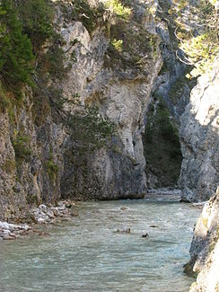
The Karwendelbach in the gorge just before it flows into the Isar |
||
| Data | ||
| Water code | AT : 2-6-16 | |
| location | Karwendel , Tyrol , Austria | |
| River system | Danube | |
| Drain over | Isar → Danube → Black Sea | |
| source | in the Grabenkar below the Grabenkarspitze 47 ° 26 '11 " N , 11 ° 25' 29" E |
|
| Source height | 1895 m above sea level A. | |
| muzzle | at the Scharnitzer Alm in the Isar Coordinates: 47 ° 22 '49 " N , 11 ° 17' 5" E 47 ° 22 '49 " N , 11 ° 17' 5" E |
|
| Mouth height | 976 m above sea level A. | |
| Height difference | 919 m | |
| Bottom slope | 60 ‰ | |
| length | 15.4 km | |
| Catchment area | 48.4 km² | |
| Left tributaries | Lauchkarbach | |
| Communities | Scharnitz | |
The Karwendelbach is a 15.4 km long right tributary of the Isar in the Karwendel in Tyrol .
course
The Karwendelbach rises in the Grabenkar below the Grabenkarspitze and initially flows in a southerly direction. It takes thelauchkarbach from the left and then runs in a westerly, then in a south-westerly direction through the Karwendel valley . Before leaving the Hinterau valley , it cut into a deep gorge. At the Scharnitzer Alm, around 2 km east of the center of Scharnitz , it flows into the Isar. The entire course lies in the municipality of Scharnitz.
Other tributaries in the Karwendeltal are the Neunerkarbach, the Großer Riedlkarbach and the Wasserlegraben from the left and the Kirchlbach from the right.
Catchment area and water supply
The catchment area of the Karwendelbach is 48.4 km², the highest point in it is the Birkkarspitze at 2749 m above sea level. A. The Karwendelbach has a similar flow regime , which is determined by the snowmelt in spring. The lowest mean water level is measured in December, the highest in May.
ecology
The banks of the Karwendelbach are mostly in a natural state, in the area around the Larchetalm in a natural state. The ecological status is rated as very good or good throughout the course.
Web links
Individual evidence
- ↑ a b c d e f TIRIS - Tyrolean spatial information system
- ^ Ministry for an Austria worth living in (ed.): Hydrographisches Jahrbuch von Österreich 2012. 120th volume. Vienna 2014, p. OG 13, PDF (13.6 MB) on bmlrt.gv.at (yearbook 2012)
