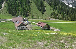
Eppzirler Alm
| Eppzirler Alm | ||
|---|---|---|
|
The Eppzirler Alm |
||
| location | Tyrol , Austria | |
| Geographical location | 47 ° 19 '52 " N , 11 ° 16' 2" E | |
|
|
||
The Eppzirler Alm is located at the western end of the Karwendel in Tyrol in Austria .
geography
From the nearest town of Gießenbach between Scharnitz and Seefeld in Tyrol , the deeply incised access to the large pasture area of the Eppzirler Alm with a refuge at the end of the Eppzirler Valley at 1,459 m opens up in a southerly direction along the Gießenbach . A. . The Alm is surrounded by the horseshoe of the peaks of the Erlspitz group such as Karlspitze, Erlspitze , Freiungspitzen, Reither Spitze and Seefelder Spitze with heights between 2400 and 2200 m.
history
The pasture, with grazing rights and more than 5 km² of land owned by the Zirl Agricultural Community, has been pounded by Zirl from the Inn Valley up to the Seefelder Sattel with around 100 cattle for centuries. In the second half of the 19th and in the first decades of the 20th century, the Alm had the second name "Goldalpe". Up to 10 pits were exploited there from the oil shale deposits for the production of rock oil for medical purposes and of asphalt as a floor covering. Immediately after the annexation of Austria in the spring of 1938, the Mittenwald mountain combat school tried to set up a barracks on the Eppzirler Alm as a base for mountain training. In 1939 construction began on the approx. 100 m long barracks. From 1942 mountain training was carried out from there. On February 7, 1945, a huge avalanche caught a course for officer candidates on a ski tour to the Eppzirler Scharte above the Alm. Three of the 21 mountain hunters were able to free themselves, 18 were deeply buried, so that in the first days after the accident only 10 men found dead, recovered and brought to Seefeld. The remaining 8 soldiers were searched and dug up until August. A memorial plaque was attached to the chapel in June 2020.
After extensive mountain testing, one of the few German helicopters built in series, the Focke-Achgelis Fa 223 with the serial number V 16 , was abandoned on the Eppzirler Alm. Since no helicopter should fall into the hands of the enemy, the designer and test pilot Carl Bode flew the V 16 on April 30, 1945 to the Eppzirler Alm, which he knew from the test flights in autumn 1944 and blew it up in the scree above the Alm with two Hand grenades. Two other machines in the series, the V 14 and the V 17, came into the hands of the British and the Americans.
After the war, the building of the barracks was demolished in 1947 by order of the French occupying forces. The material was used to repair the houses in Scharnitz and Reith near Seefeld, which were destroyed by bombs in the last days of the war . The massive basement vaults in 1983 by pioneers of the Armed Forces blown up and leveled.
A little above the alpine building, the Marien-Kapelle was built in 2010, where the annual "Almkirta" is celebrated.
tourism
An inn was built near the alpine huts to serve and accommodate hikers, mountaineers and skiers. The hut is privately owned and is open from late May to early October. It offers 18 mattress dormitories , six of them in the main building and twelve in a small outbuilding. The hut is equipped with toilets and showers. Despite several considerations until the 1970s to connect and develop the Eppzirler Alm with the Seefeld ski area, this gem of alpine alpine pastures and high mountain landscapes was preserved as such. The reasons for this are the seriousness of the alpine dangers and the tenacity of the Zirl agricultural community to protect and preserve their pastures.
The Alm is the starting point for tours over the Eppzirler Scharte ( 2104 m above sea level ) and the Erlspitze ( 2405 m above sea level ) to the Solsteinhaus ( 1806 m above sea level ) or via the Freiungen-Höhenweg to the Nördlinger hut ( 2239 m above sea level ).
Individual evidence
- ↑ Marktgemeinde Zirl, death register, entry from September 24, 1945
- ↑ Focke-Achgelis Fa 223 'Dragons'. www.luftarchiv.de, accessed on August 10, 2020 .
- ↑ Springmann Enno, Focke. Planes and helicopters by Heinrich Focke 1912-1961, Oberhaching 1997, p. 215
- ↑ Niederkircher, Johann, The history of the Eppzirler Alm as a mirror of the history of Tyrol . Diploma thesis, University of Innsbruck, January 2011.


