Back brook furnace tip
| Back brook furnace tip | ||
|---|---|---|
|
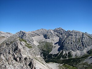
The rear Bachofenspitze from the southwest |
||
| height | 2668 m above sea level A. | |
| location | North of Innsbruck | |
| Mountains | Gleirsch-Halltal chain , Karwendel | |
| Dominance | 0.72 km → Rosskopf | |
| Coordinates | 47 ° 20 '44 " N , 11 ° 26' 18" E | |
|
|
||
| rock | Wetterstein lime | |
| Age of the rock | Triad | |
| Normal way | Southwest side, UIAA II | |
|
The rear Bachofenspitze (left of the center of the picture) above the Sonntagkar |
||
|
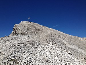
Summit construction at the rear Bachofenspitze |
||
The rear Bachofenspitze in the Karwendel in Tyrol is 2668 m above sea level. A. the northernmost point of the municipality of Thaur im Inntal, which extends to this point . The Vordere Bachofenspitze is about 400 meters east of the summit ( ⊙ , 2663 m above sea level ). Since the erection of a summit cross , which was erected in October 2003 by Franz Brunner and Fritz Gostner, this summit has enjoyed growing popularity.
location
The Hintere Bachofenspitze in the Gleirsch-Halltal chain separates the Gleirsch chain in the west from the Hall valley chain in the east. It is also the northernmost summit of the connecting ridge, which runs south over the Rosskopf to the Stempeljochspitzen and connects to the Nordkette . The north face of the Hinteren Bachofenspitze falls 700 m to the Kleiner Gschnierkopf ( 1899 m above sea level ) in the Hinterautal .
Routes to the summit
The easiest and shortest way to reach the summit is from the Pfeishütte ( 1922 m above sea level ) via the marked path through the Sonntagkar in the south-west. The route through the rock barrier in the upper part is also well marked and provided with some step irons ( UIAA II ). Another approach leads from the Wilde Bande-Steig in the southeast through the Bachofenkar to the southeast . In the rearmost part of the cirque you climb northwards through a brittle channel to the gap between the Vorderer and Hinterer Bachofenspitze. From here on the ridge or just below it westwards to the summit (difficulty level I). In addition, the summit can be reached by crossing the ridge either from the Sonntagkarspitze (III), from the Rosskopf (II) or from the Großer Lafatscher via the Vordere Bachofenspitze (II).
The transition to the Vorderen Bachofenspitze has difficulty level II. The Vordere Bachofenspitze can also be reached via the southeast flank or from the Bachofenkar, also with difficulty II.
literature
- Walter Klier : Alpine Club Guide Karwendel alpine . 14th edition. Bergverlag Rudolf Rother, Munich 1996, ISBN 3-7633-1121-1 .


