Johannesbach (Rissbach)
| Johannesbach | ||
|
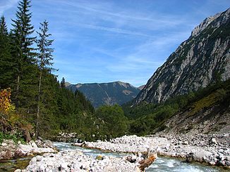
The Johannesbach, looking north |
||
| Data | ||
| Water code | AT : 2-6-23-26 | |
| location | Karwendel , Tyrol | |
| River system | Danube | |
| Drain over | Rissbach → Isar → Danube → Black Sea | |
| origin | west of the Kleiner Mapleboden 47 ° 25 ′ 9 ″ N , 11 ° 27 ′ 53 ″ E |
|
| Source height | 1437 m above sea level A. | |
| muzzle | at the Fuggerangeralm in the Rißbach Coordinates: 47 ° 27 '50 " N , 11 ° 29' 48" E 47 ° 27 '50 " N , 11 ° 29' 48" E |
|
| Mouth height | 950 m above sea level A. | |
| Height difference | 487 m | |
| Bottom slope | 66 ‰ | |
| length | 7.4 km | |
| Catchment area | 29.94 km² | |
| Communities | Vomp | |
|
The Johannesbach flows into the Rissbach (center). In the background Rosskopf (left) and Fleischbank (right) |
||
The Johannesbach is a 7 km long torrent in Tyrol that flows through the Johannestal in the Karwendel .
It rises west of the Kleiner Ahornboden and then flows through it. From the height of the Schwarzlackenhütte ( 1204 m above sea level ) the stream flows freely accessible on the valley floor, disappears at the valley entrance in a gorge, from which it enters the gravel bed of the Riss valley, where it flows from the left into the Rissbach .
The catchment area of the Johannesbach is 30 km², the highest point in it is the Birkkarspitze at 2749 m above sea level. A.

