
Blue ice

Coordinates: 47 ° 34 ′ 25 ″ N , 12 ° 51 ′ 56 ″ E
The Blaueis is the northernmost glacier in the Alps and is located in the municipality of Ramsau in the Bavarian part of the Berchtesgaden Alps . The glacier is exposed on the north side in the upper Blaueiskar, embedded between the walls of the Blaueisspitze ( 2480 m ), high ( 2607 m ) and small ( 2513 m ), which surround the glacier in a horseshoe shape.
Glacier retreat
Because of its relatively low altitude, the blue ice is particularly affected by the retreat of the alpine glaciers. Around the year 1820 the first maps showed a total area of 25 ha. In 1884 an area of 19.6 ha was measured; In 1953 the blue ice had shrunk to 13.1 hectares. Since the mid-1980s, more and more rocks have gashed out in the middle of the blue ice , which have now completely separated the upper part of the glacier from the lower dead ice field, the former glacier tongue. The decline in the ice mass in the lower field is particularly strong because, due to the separation, it no longer receives supplies from the higher glacier area. Both ice fields together measured only 7.5 hectares in 2009. The thickness of the ice determined with georadar was (only) up to 13 meters in 2007, the average ice thickness less than four meters; the volume is given as around 400,000 m³. This means that the amount of residual ice is less than the loss in mass in the last decade of the 20th century.
Geotope
The Blue Ice Glacier has been identified as a valuable geotope by the Bavarian State Office for the Environment (Geotope number: 172R026).
Tour possibilities
The base for inspections of the glacier is the Blaueishütte , located 1651 m high in the Blaueiskar below the glacier , which can be reached from Ramsau or Hintersee in a good three hours' walk.
Over the glacier, which is up to 55 ° steep in its upper part, an ascent leads to the Blaueisscharte (approx. 2400 m ), from which you can climb to the Hochkalter summit in easy climbing ( difficulty UIAA II). This route was first committed by the Ramsau mountain guide Johann Grill (called Kederbacher) in 1874 with E. Richter. Favorable season is when there is still a snow cover facilitates the rise and often still snow bridges usually the second half of June, a simple crossing of the crevasse permit under the saddle. In late summer and autumn, the gap is wide and often difficult to cross. At this time of the year, some fatal crashes were recorded in the past due to the clear ice emerging.
A popular long ridge climb is "blue ice framing". It leads from the Blaueishütte via Schärtenspitze , Blaueisspitze, Hochkalter, Kleinkalter and Rotpalfen back to the starting point without touching the glacier . The main difficulties lie in overcoming the Blue Ice North Ridge, a climb with difficulty IV on the UIAA scale.

The blue ice glacier, which has receded significantly in 2003

Blue Ice Glacier (April 2007)
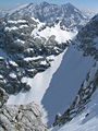
Blaueis Glacier with Blaueisscharte and Blaueisspitze, as well as Watzmann in the background (April 2007)


Web links
Individual evidence
- ^ Archives of the Bavarian Glaciers
- ↑ Bavarian State Ministry for Environment and Health (ed.): Bavarian Glaciers in Climate Change. A status report. Munich 2012, p. 15, 20. Full text online (PDF; 3.2 MB), accessed on July 6, 2013.
- ^ Bavarian State Office for the Environment, Geotop Blaueisgletscher am Hochkalter (accessed on October 19, 2017).
Remarks
-
↑ In 1925, Friedrich Thiersch (1876–1951), son of August Thiersch and student of Sebastian Finsterwalders , made an accurate photogrammetric picture of the blue ice for the first time. While the end of the glacier's tongue was still at 1920 m above sea level in that year, the altitude in 1949/50 was already 2140 m. - See: Richard Finsterwalder : Das Blaueis am Hochkalter . From: -: The glaciers of the Bavarian Alps . In: Yearbook of the German and Austrian Alpine Club (bridging volume of the Alpine Club magazine 1943–1951) . Schmitt, Munich 1951, p. 61. (Online at ALO ).
According to the height table in the Bavarian glacier archive, the value given in 1949/50 is difficult to understand. The reason for this could be that due to the division of the glacier into an upper and a lower field due to the aperitif, the reference value end of the tongue was not clearly defined.