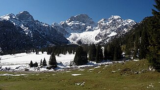
Rontalbach
|
Rontalbach Rhontalbach |
||
|
Rontalbach in the Rontalboden |
||
| Data | ||
| Water code | AT : 2-6-23-34 | |
| location | Karwendel , Tyrol | |
| River system | Danube | |
| Drain over | Rissbach → Isar → Danube → Black Sea | |
| origin | below the Rappenklammspitze 47 ° 28 '9 " N , 11 ° 24' 46" O |
|
| Source height | 1660 m above sea level A. | |
| muzzle | in the Rißbach coordinates: 47 ° 28 '26 " N , 11 ° 27' 57" E 47 ° 28 '26 " N , 11 ° 27' 57" E |
|
| Mouth height | 920 m above sea level A. | |
| Height difference | 740 m | |
| Bottom slope | approx. 11% | |
| length | approx. 7 km | |
| Communities | Vomp | |
The Rontalbach or Rhontalbach is a 7 km long wild stream in Tyrol that flows through the Rontal in the Karwendel .
Its main branch rises from the Rappenklammspitze, but its catchment area includes other secondary branches of the entire Rontal. It flows in a largely eastward direction before finally flowing into the Rißbach from the left in the Riss valley .
