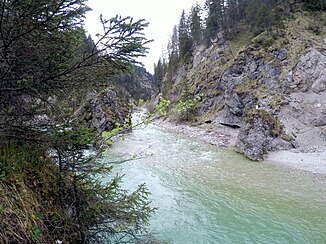
Fermersbach
| Fermersbach | ||
|
The Fermersbach flows into the Rissbach |
||
| Data | ||
| Water code | DE : 16146 | |
| location |
Northern Limestone Alps
|
|
| River system | Danube | |
| Drain over | Rissbach → Isar → Danube → Black Sea | |
| source | North side Bäralplkopf 47 ° 27 '9 " N , 11 ° 23' 4" O |
|
| Source height | 1531 m | |
| muzzle | shortly before the Rißbachwehr from the left into the Rißbach coordinates: 47 ° 31 '4 " N , 11 ° 26' 32" E 47 ° 31 '4 " N , 11 ° 26' 32" E |
|
| Mouth height | 834 m | |
| Height difference | 697 m | |
| Bottom slope | 64 ‰ | |
| length | 11 km | |
| Catchment area | 35.77 km² | |
| Left tributaries | Sandbach | |
| Right tributaries | Aubach | |
The Fermersbach , in the upper reaches of Bärnbach , is a year-round flowing water in the Karwendel and forms the border between Bavaria, Germany and Tyrol, Austria for 8.99 km.
geography
course
The Fermersbach arises as Bärnbach below the Bärnalpkopf in German territory, before it forms the German-Austrian border from the inlet from the Wechselgraben. It takes up the Sandbach from the left and then runs in the valley between Vorderkopf in the south and the ridge of the Galgenstangenjoch in the north to the confluence with the Rißbach.
The Fermersbach also forms the southern border of the Karwendel and Karwendel foothills nature reserve .
On historical maps, the Fermersbach arises from the confluence of Moosgraben-Vereinbach and Sandbach. The Bärnbach (historically: Bernbach) was thus the right tributary.
Tributaries
The Fermersbach with its numerous tributaries drains the entire approximately 9 km long, otherwise nameless valley, which extends between the ridge of the Galgenstangenjoch in the north, the relatively independent front head in the south and the valley head with Soiernspitze, the ridge of the northern Karwendel range and the Rappenklammspitze . At the end of the valley there are also the westernmost tributaries with the Sandbach and Moosgraben-Vereinbach am Sattel to the western valley of the Seinsbach near the Krinner-Kofler hut . Another important branch comes with the Bärnbach, referred to on today's maps as the upper reaches of the northern slopes of the northern Karwendel range. Also worth mentioning is the tributary of the Aubach, which arises on the saddle between Vorderkopf and Ronberg near the Vorderbachau .
Individual evidence
- ↑ a b List of brook and river areas in Bavaria - Isar river area, page 5 of the Bavarian State Office for the Environment, as of 2016 (PDF; 2.5 MB)
