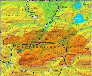
Werdenfelser Land
| Werdenfelser Land | |
|---|---|
| State : | Bavaria |
| Administrative districts : | Upper Bavaria |
| Area : | approx. 484 km² |
| Residents : | approx. 45,000 (December 31, 2017) |
| Population density : | approx. 93 inhabitants per km² |
| The highest point: | 2962 m above sea level NHN ( Zugspitze ) |
| Lowest point: | 655 m above sea level NHN ( Loisachtal ) |
| Structure: | six parishes |
| map | |
The Werdenfels denotes a Upper Bavarian region stretching from the mid forest in the south to Farchant extends. It covers parts of the Bavarian Alps .
The region is named after the medieval Werdenfels castle north of Garmisch-Partenkirchen . The castle was primarily used to secure the army and trade route that led through the Loisach valley and connected trading centers in Italy and Upper Bavaria .
In 2006, Werdenfelser Land was included in the list of 77 awarded national geotopes in Germany.
Communities
Garmisch-Partenkirchen is the cultural center . The following places also belong to the Werdenfelser Land:
geography
The southern Werdenfelser Land is bordered by the Wetterstein Mountains and the Karwendel . The Zugspitze is located southwest of Garmisch-Partenkirchen and is 2962 m above sea level. NN the highest mountain in Germany. Both the valleys and the foothills of the Alps were strongly shaped by the last Ice Age. The lakes are z. This was partly caused by groundwater filling the depressions created by the glaciers. Later the lakes silted up and bogs formed , such as the Murnauer Moos .
history
In the early Iron Age , the Werdenfelser Land was settled by Illyrians . Already at this time there were close contacts via the later Brenner - Scharnitz- Strasse to Northern Italy. From around 500 BC Chr. Penetrated Celts in this area, and mingled with the local population.
The Romans, in turn, subjugated the Celts around 15 BC. And assigned the area to the province of Raetia . Occasionally the Romans took over settlement and river names of Veneto-Illyrian or Celtic origin. Some of them survived to the present day, for example Partenkirchen - Partanum , Isar - Isara . The already existing trade route was expanded from 195 AD. The Via Raetia led from Augsburg via Partenkirchen and Mittenwald via the Seefelder Sattel and Veldidena ( Wilten / Innsbruck ) to the Brenner and on to Bozen (Pons Drusi), where it merged into the older Via Claudia Augusta . The Roman road station Partanum is the forerunner of today's Partenkirchen.
In the years 1073-1078, detailed information about the episcopal-Freising border in the Werdenfelser Land is made in a record of the Hochstift Freising . Werdenfels Castle, built between 1180 and 1230 northwest of Garmisch, went to the Hochstift Freising in 1294 . The control of the northern accesses of the important European trade route by the Freising Prince-Bishops brought the population of the County of Werdenfels a relative prosperity over a long period of time.
With the beginning of modern times , there was a significant economic upswing due to the increased trade relations with Italy ( see also: Fugger , Welser ). The nickname Goldenes Landl for Werdenfelser Land comes from this time. The Thirty Years' War ended this development; the population became impoverished. Later wars, such as the Spanish and Austrian War of Succession at the beginning of the 18th century, and the Napoleonic Wars in the 19th century , also badly affected the population. In 1803 the rule of the Hochstift Freising ended and the Werdenfelser Land became part of Bavaria.
With the railway connection with Munich established in 1889, tourism began.
See also
literature
- Wolfgang Wüst : Change in the Golden Landl 200 years ago. The market in Partenkirchen and the county of Werdenfels in secularization trauma , in: Mohr - Löwe - Raute. Contributions to the history of the district of Garmisch-Partenkirchen 11, ed. v. Association for history, art and cultural history in the district e. V., Garmisch-Partenkirchen 2006, pp. 141-162.
Web links
Individual evidence
- ↑ → Sources for the average number of inhabitants per km², see section: Population development and population density
- ↑ Hubert Engelbrecht: Beauty and elemental force of the earth cast in stone - The Werdenfelser Land . In: Ernst-Rüdiger Look, Ludger Feldmann (Ed.): Fascination Geology. The important geotopes of Germany. E. Schweizerbart'sche Verlagsbuchhandlung, Stuttgart 2006, ISBN 3-510-65219-3 , pp. 166f.
- ↑ Martin Bitschnau , Hannes Obermair : Tiroler Urkundenbuch, II. Department: The documents on the history of the Inn, Eisack and Pustertal valleys. Volume 1: By the year 1140 . Universitätsverlag Wagner, Innsbruck 2009, ISBN 978-3-7030-0469-8 , p. 217-218, no. 245 .
- ↑ Joachim Zeune : Traces of the Past . Ed .: Heinrich Spichtinger. Adam-Verlag, Garmisch-Partenkirchen 1999, The castle of the early 13th century, p. 17 .
- ^ Werner Meyer : Castles in Upper Bavaria . Würzburg 1986.

