Yser
| Yser | ||
|
Location of the Yser |
||
| Data | ||
| Water code | FR : E4900570 | |
| location | France , Hauts-de-France region and Belgium , West Flanders | |
| River system | Yser | |
| River basin district | Scheldt | |
| source | in the municipality of Buysscheure 50 ° 48 ′ 51 ″ N , 2 ° 20 ′ 9 ″ E |
|
| Source height | approx. 30 m | |
| muzzle | at Nieuwpoort in the North Sea Coordinates: 51 ° 9 ′ 10 ″ N , 2 ° 43 ′ 25 ″ E 51 ° 9 ′ 10 ″ N , 2 ° 43 ′ 25 ″ E |
|
| Mouth height | 0 m | |
| Height difference | approx. 30 m | |
| Bottom slope | approx. 0.38 ‰ | |
| length | 78 km | |
| Catchment area | 1101 km² | |
| Drain |
MQ |
3 m³ / s |
| Left tributaries | Zwyne Becque | |
| Right tributaries | Ieperlee , Peene Becque , Ey Becque | |
|
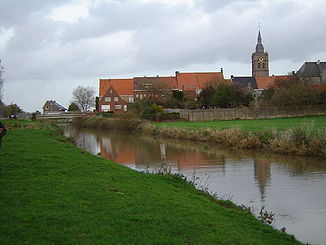
The Yser in Roesbrugge |
||
The Yser (French) or IJzer (Dutch) is a 78 km long coastal river in the border area between French and Belgian Flanders .
course
The Yser rises in the French commune of Buysscheure in the Nord department , generally drains in a north-easterly direction and flows into the North Sea at Nieuwpoort ( West Flanders Province ) .
Places on the river
- Broxeele
- Bollezeele
- Zegerscappel
- Esquelbecq
- Wylder
- Bambecque
- Roesbrugge-Haringe
- Elzendamme
- Diksmuide
- Schoorbakke
- Nieuwpoort
history
During the First World War , the battles of Flanders took place in the Yser catchment area . From October 29, 1914, the Belgians dammed the Yser outflow on the Yser Front and flooded part of the Yser Valley. As a result, the Germans were forced to retreat to the right bank of the river on November 2, 1914.
Trivia
The asteroid (12276) IJzer was named after the river.
Footnotes
- ↑ Article Yser on www.be14-18.de, the portal on the First World War in Belgium, accessed on November 1, 2014.
Web links
Commons : Yser - collection of images, videos and audio files
Wiktionary: Yser - explanations of meanings, word origins, synonyms, translations


