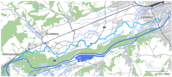
Klötzlmühlbach
| Klözlmühlbach | ||
|
Course of the Klötzlmühlbach |
||
| Data | ||
| Water code | DE : 167222 | |
| location |
Bavaria
|
|
| River system | Danube | |
| Drain over | Hammerbach → Kleine Isar → Isar → Danube → Black Sea | |
| source | Derivation to the left from the Amper in Volkmannsdorf 48 ° 30 ′ 2 ″ N , 11 ° 57 ′ 20 ″ E |
|
| Source height | 407 m above sea level NHN | |
| muzzle | from the left in the Hammerbach in Landshut Coordinates: 48 ° 32 '5 " N , 12 ° 8' 20" E 48 ° 32 '5 " N , 12 ° 8' 20" E |
|
| Mouth height | 391 m above sea level NHN | |
| Height difference | 16 m | |
| Bottom slope | 0.84 ‰ | |
| length | 19 km | |
| Catchment area | 54.29 km² | |
The Klötzlmühlbach is a 19 km long brook, derived from the Amper , in a roughly east-northeast running direction, which flows into the Isar via the Hammerbach in Landshut .
geography
course
The Klötzlmühlbach is diverted to the left at the Wanger village of Volkmannsdorf at the Amper weir immediately before its confluence with the Isar and runs for the first few kilometers in the Isar floodplains. After the first few meters in the Freising district, the stream continues to flow through the Bruckberg community in the Landshut district , south of the Bruckbergerau district . Shortly before Landshut airfield , the stream reaches the area of the city of Landshut. On the western outskirts of Landshut, the brook crosses the Landshut flood basin underground . At the Stadtbad Landshut it flows from the left into the much shorter Hammerbach, which is derived from the Isar.
The 19 km long Klötzlmühlbach has a very irregular, meandering course, so the distance between the branch and the confluence is only 14 km as the crow flies.
Catchment area
The catchment area of the Mühlbach is 54.29 km². Most of the catchment area is in the north, i.e. to the left of the Klötzlmühlbach. From there the Möslingbach ⊙ in Bruckbergerau and the Seebach ⊙ flow into the Klötzlmühlbach a little before Landshuter Münchnerau . The catchment area borders in the south on the Isar , which is almost always very close , in the northeast on the Pfettrach , and in the west on the catchment areas of the Hörgertshausener Bach and the Mauerner Bach.
The Klötzlmühlbach initially runs in the Young Holocene floodplain sediments, then for a long time in the Old to Middle Holocene gravel deposits of the left Isar floodplain.
Mills on the run
![]() Map with all coordinates of the section Mühlen am Lauf : OSM
Map with all coordinates of the section Mühlen am Lauf : OSM
In its course, the stream was the source of energy for six mills:
Individual evidence
BayernAtlas ("BA")
Official online waterway map with a suitable section and the layers used here: Course and catchment area of the Klötzlmühlbach
General introduction without default settings and layers: BayernAtlas of the Bavarian State Government ( notes )
- ↑ a b Height queried on the background layer Official map (right click).
- ↑ Geology according to the layer geological map 1: 500,000 .
Water directory Bavaria ("GV")
- ↑ Length according to: List of brook and river areas in Bavaria - Isar river area, page 82 of the Bavarian State Office for the Environment, as of 2016 (PDF; 2.5 MB) (number of pages may change.)
- ↑ Catchment area according to: List of brook and river areas in Bavaria - Isar river area, page 82 of the Bavarian State Office for the Environment, as of 2016 (PDF; 2.5 MB) (number of pages may change.)
literature
- Official topographic map (ATK) 1: 25,000 No. L13 Pfeffenhausen of the State Office for Digitization, Broadband and Surveying Bavaria
