
Three-goal spike
| Three-goal spike | ||
|---|---|---|
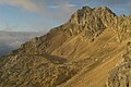
 Partenkirchner Dreitorspitze with Herrmann-von-Barth-Weg from the south |
||
| height | 2682 m above sea level A. | |
| location | Bavaria , Germany and Tyrol , Austria | |
| Mountains | Wetterstein Mountains | |
| Dominance | 5.2 km → Hochwanner | |
| Notch height | 346 m ↓ Western Wangscharte | |
| Coordinates | 47 ° 24 '0 " N , 11 ° 7' 26" E | |
|
||
| rock | Wetterstein lime | |
| Age of the rock | Triad | |
| First ascent | West summit of the Partenkirchen Dreitorspitze: K. Kiendl, J. Grasegger (1854) Transition to the central summit: Hermann von Barth (1870) |
|

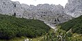
The Dreitorspitze is a multi-peaked, powerful and very striking mountain range in the eastern part of the Wetterstein Mountains . This is divided into the Partenkirchner ( 2633 m above sea level ) and the Leutascher Dreitorspitze ( 2682 m above sea level ), both of which have several peaks. The main peak of the fourth highest mountain range in Germany is the Leutascher Dreitorspitze, also known as the Karlspitze . The three-gate peak marks the point where the main chain of the Wetterstein deviates from its main direction (west-east) to the north, only to return shortly afterwards to the main direction. To the east of the Dreitorspitze lies the karst plateau of the Leutascher Platt, comparable to the Zugspitzplatt at the foot of the Zugspitze .
The main peaks can be climbed the easiest way in the 1st or 2nd degree of difficulty . An easy via ferrata secured with wire ropes , named after the famous explorer of the Northern Limestone Alps, Hermann von Barth , leads to the western summit of the Partenkirchen Dreitorspitze . All other peaks are reserved for climbers. An ascent usually takes place as part of a two-day tour with an overnight stay at the Meilerhütte, a day tour has very high physical requirements.
- Valley locations: Partenkirchen (D), Leutasch (Austria), Mittenwald (D)
- Support points: Meilerhütte (DAV section Garmisch-Partenkirchen )

Seen from the southeast, the Dreitorspitze appears as the main summit of the Wettersteinkamm

photos

Three-gate spikes from SO
Leutascher Dreitorspitze from the north

Leutascher Dreitorspitze from the Partenkirchner Dreitorspitze
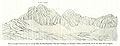
Leutasch three-gate tip drawing by H. v. Barth 1873
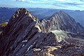
View from the western summit of the Partenkirchner Dreitorspitze to the central and northeastern summit and the Musterstein

Bowl karbivak from the western Partenkirchner Dreitorspitze

Panoramic view from the west summit of the Partenkirchner Dreitorspitze

Entry of the Hermann-von-Barth -Weg
Söllerpass from S

Partenkirchner Dreitorspitze Drawing by H. v. Barth 1873


Web links
Individual evidence
- ↑ Geological map of Bavaria with explanations (1: 500,000). Bavarian Geological State Office, 1998.