
Hochwanner
| Hochwanner | ||
|---|---|---|
 Hochwanner south face |
||
| height |
2744 m above sea level NHN 2744 m above sea level A. |
|
| location | Bavaria , Germany and Tyrol , Austria | |
| Mountains | Wetterstein Mountains | |
| Dominance | 5 km → Zugspitze | |
| Notch height | 699 m ↓ Feldernjöchl | |
| Coordinates | 47 ° 23 '45 " N , 11 ° 3' 15" E | |
|
||
| First ascent | August 3, 1871 by Hermann von Barth | |
| Normal way | About Hochwannerkar (weglos, I ) | |

The Hochwanner (outdated: Kothbachspitze ) is a mountain in the Wetterstein Mountains . He is with 2744 m above sea level. NHN is the second highest mountain in Germany after the Zugspitze (provided that the even higher Schneeernerkopf and the also slightly higher weather peaks are only viewed as secondary peaks of the Zugspitze).
location
The Hochwanner is located on the German-Austrian border between Garmisch-Partenkirchen and Leutasch . It is the highest peak in the Wetterstein main ridge, which stretches across from the Gatterl to the Upper Wettersteinspitze above Mittenwald in a west-east direction. From the Hochwanner massif down there is a magnificent all-round view of the Reintal, the Austrian Leutasch Valley, the Gaistal , the Zugspitze, the Mieminger chain , the Jubiläumsgrat , the Karwendel Mountains and far into the Central Alps .
The Hochwanner remains a relatively unknown mountain despite its great height and its spectacular north face dropping over 1400 m (one of the highest rock faces in the entire Northern Limestone Alps ). This is due to its inaccessible location, hidden behind the Alpspitze and Höllentalspitze . The much better known, but less high Watzmann is therefore often incorrectly referred to as the second highest mountain in Germany.
Since the Hochwanner summit is exactly on the state border, it forms at 2744 m above sea level. A. also at the same time the highest elevation in the parish of the Tyrolean community of Leutasch . The summit cross was erected by a donor family from Leutasch.
Ascent
The slightest ascent to the summit takes place from the south via the Mitterjöchl, located between Steinernem Hüttl and Rotmoosalm near the Predigtstuhl . This can be reached either via the Gaistal from Leutasch or from Gatterl . From there it is partly pathless or only recognizable as a weak track in a good two hours over steep lawns, later over a short climbing point (up to I on the UIAA scale ) and then mainly over steep, arduous scree slopes to the summit. The route is sparsely marked with stone men .
The north face is considered a breathtaking, very long climbing tour.
See also: Great north faces of the Alps
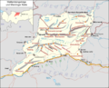
Wetterstein Mountains and Mieming Range

View from the summit of the Hochwanner to the west

Reintal below the Hochwanner around 1900

The north face of the Hochwanner


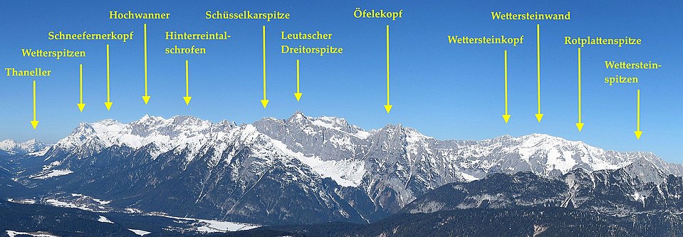
The Hochwanner in the Wetterstein main ridge

literature
- Stefan Beulke: Alpine Club Leader Wetterstein . 4th edition. Bergverlag Rother, Munich 1991, ISBN 3-7633-1119-X
- The unknown number two . In: Section Munich of the German Alpine Club (Ed.): Alpinwelt . No. 1 , 2013, p. 36 ( PDF ).
cards
- German Alpine Club (Ed.): Alpine Club Map Bavarian Alps Part 8 - Wetterstein Mountains, Zugspitze (1: 25,000). 2nd Edition. Alpenvereinsverlag, Munich 2014, ISBN 978-3-937530-63-5
- German Alpine Club (Ed.): Alpine Club Map 4/2 - Wetterstein and Mieminger Mountains Center (1: 25,000). 5th edition. Alpenvereinsverlag, Munich 2007, ISBN 978-3-9287-7720-9
Web links
Individual evidence
- ↑ State Office for Surveying and Geoinformation Bavaria : BayernAtlas .
- ↑ a b Federal Office for Metrology and Surveying Austria: Austrian Map online (Austrian map 1: 50,000) .
- ↑ Eduard Richter : The Development of the Eastern Alps Volume 1 . Publishing house of the German and Austrian Alpine Club, 1893, p. 141.
- ↑ Federal Statistical Office (ed.): Zahlenkompass 1997, ISBN 3824605171 ( online preview )
- ↑ Günter Kast: The lonely Second Mirror Online , July 29, 2020, accessed on July 30, 2020