
Schneeernerkopf
| Schneeernerkopf | ||
|---|---|---|
 Snowernerkopf (from left: Zugspitzeck, Zugspitze, snowernerkopf, Wetterspitzen, Wetterwandeck), |
||
| height | 2875 m above sea level NN | |
| location | On the border between Bavaria and Tyrol or Germany and Austria | |
| Mountains | Wetterstein Mountains , Alps | |
| Dominance | 1.7 km → Zugspitze | |
| Notch height | 176 m | |
| Coordinates | 47 ° 24 '36 " N , 10 ° 58' 13" E | |
|
||
| First ascent | 1871 Hermann von Barth | |
| Normal way | From the Zugspitzplatt via the Schneefernerscharte | |
 The Schneeernerkopf from the northeast |
||

The Schneeernerkopf is a 2875 m high summit in the Zugspitze massif . It is located at the western end of the Wetterstein Mountains in the Alps on the border between Bavaria and Tyrol or Germany and Austria . Seen especially from Ehrwald , it appears as the dominant mountain of the Wetterstein.
Delimitation to the Zugspitze
Whether the Schneeernerkopf can be regarded as the “second highest mountain in Germany” after the Zugspitze depends heavily on the definition of the term mountain . Due to its proximity to the Zugspitze ( dominance 1.7 km), it is questionable whether it can be counted as an independent mountain or just as a secondary peak of the Zugspitze. Its notch height is 176 m. If it is not rated as an independent mountain, then the second place among Germany's highest mountains falls to the Hochwanner ( 2746 m ), which is clearly separated from the Zugspitze massif by Reintal , Gatterl and Feldernjöchl . The third highest mountain is the Watzmann in the Berchtesgaden Alps at 2713 m .
Base and easiest ascent
The easiest way to climb the Schneefernerkopf is from the Zugspitzplatt . The path leads over the remains of the Schneeferner or past it to the Schneefernerscharte. Here is the "wind hole", a weathered formation with a deep view of Ehrwald. To the summit, it goes over the north shoulder on steps and over a path secured with wire ropes, which follows the facilities of the Snowernerkopf lift, which was closed in 2003 but not dismantled. The total walking time is just under an hour, surefootedness and a head for heights are essential.
At the end of a ski tour , an extremely demanding ski run , the New World , leads from the Schneefernerkopf over almost 2000 meters in altitude to Ehrwald. It is very exposed, up to 45 degrees steep and contains a rappelling point that is rated UIAA III on the ascent .

The Schneeernerkopf seen from the northwest

View down from the Schneefernerscharte to Ehrwald

"Wind hole" on the Schneefernerscharte
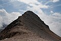
The summit area of the Schneefernerkopf from the north shoulder
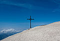
Cross on the north shoulder of the Schneefernerkopf


Literature and map
- Stephan Beulke: Wetterstein. A guide for valleys, huts and mountains (= Alpine Club Guide . Series: Northern Limestone Alps. ). Written according to the guidelines of the UIAA. 4th, unchanged edition. Bergverlag Rother, Munich 1996, ISBN 3-7633-1119-X .
- Alpine Club Map 1: 25,000, sheet 4/2, Wetterstein and Mieminger Mountains.
See also: List of the highest mountains in Germany