Reintal (Wetterstein)
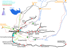
Reintal is the name given to the upper and lower valley of the Partnach between the Zugspitzplatt and the Partnachklamm .
The valley was during the Würm created by the "Reintalgletscher" and in the post-glacial, after withdrawal of the glacier to the edge position of the Schneefernerhaus head deepened by the Partnach. The upper Reintal, which is shaped by the Reintal glacier and is now a trough valley , ends between the high Gaifkopf in the west and the Schachen in the east. The lower Reintal is already in the area of the former glacier sea of the Loisach glacier, to which the Reintal glacier flowed from the southwest. It is formed as a Kerbtal and predominantly shaped by the mountain stream Partnach.
Together with the Höllental in the north, the Reintal divides the Wetterstein Mountains into several mountain ridges. The northern border is formed by the ridges of the Höllentalspitzen ( 2743 m ) and the Hohe Gaifkopf ( 1864 m ). The highest points on the southern valley flank are on the Hochwanner ( 2744 m ), the Hinterreintalschrofen ( 2670 m ) and the Dreitorspitze ( 2682 m ). The valley floor lies in an altitude range between 1400 m above sea level. NN at the Partnachursprung, 1002 m above sea level. NN at the entrance of the rear gorge and 797 m above sea level. NN at the beginning of the Partnach Gorge, in the upper Reintal, about 1300 to 850 meters below the surrounding mountain peaks. In the upper Reintal, masses from landslides from the north faces of Hochwanner and Hinterreintalschrofen also play a role in the formation of the valley. Through them, the former trough valley floor was buried, the course of the Partnach pushed north and dammed in places.
The use of the Reintalangeralm can already be proven for the year 1485. It was often used by Tyrolean subjects from the Leutasch , who drove their cattle there via Ehrwalder Gatterl. The front and rear blue pools were created by landslides around 1800 . The former was completely filled with sediment on August 23, 2005 by heavy rain (200 mm in 24h), whereby the natural dam broke due to the high pressure. The flood tidal wave caused considerable damage in the further valley. A total of eleven marked stopping points on a "geomorphological educational trail" in the Reintal provide information about the constant change in the landscape and the shape of the surface.
Within the Reintal, a less steep path leads to the Zugspitze , the section of which is part of the red path of the Via Alpina up to the Knorrhütte . The Bockhütte and Reintalangerhütte in the valley serve hikers and mountaineers as a snack station and starting point for numerous tours.
Due to the great distance to the village and because there are no roads into the valley, it is not very accessible and is still very close to nature, despite the easy accessibility. Together with the Wimbachtal in Ramsau near Berchtesgaden, the Reintal is believed to be one of the most impressive, large, natural valley landscapes in the Bavarian Alps . The upper Reintal is protected as a nature reserve .
Individual evidence
- ↑ Johannes Haslauer: "Only for very experienced climbers" Pre-alpine approaches to the Wetterstein Mountains and the Zugspitze. In: Alpenvereinsjahrbuch Berg 2010. Vol. 134, 2010, p. 166.
- ↑ Leki.de: Path renovation work in the Wetterstein Mountains : Hike safely to the Reintalangerhütte Archived copy ( memento of the original from July 19, 2011 in the Internet Archive ) Info: The archive link was inserted automatically and has not yet been checked. Please check the original and archive link according to the instructions and then remove this notice.
- ↑ CAT.INIST: The life span of a small high mountain lake, the Vordere Blaue Gumpe in the Bavarian Alps [1]
- ↑ Joachim Götz, Lothar Schrott (Hsgb.): Das Reintal: Geomorphological educational trail at the foot of the Zugspitze . Publishing house Dr. Friedrich Pfeil, 2010, ISBN 978-3-89937-120-8
literature
- David Morche: Investigations into fluvial sediment transport in catchment areas of the northern Limestone Alps (Reintal / Wetterstein Mountains and Lahnenwiesgraben / Ammergau Alps) [2] [3] (PDF; 2.0 MB)


