
Hinterreintalschrofen
| Hinterreintalschrofen | ||
|---|---|---|
 The Hinterreintalschrofen seen from the western summit area of the Hohen Munde . On the left in clouds the Hochwanner. |
||
| height | 2669 m above sea level A. | |
| location | Border Tyrol / Bavaria | |
| Mountains | Wetterstein Mountains | |
| Dominance | 1.5 km → Hochwanner | |
| Notch height | 110 m ↓ notch to Hochwanner | |
| Coordinates | 47 ° 23 '46 " N , 11 ° 4' 33" E | |
|
||
| First ascent | September 1, 1871 by Freiherr Hermann von Barth or in 1897 by A. Heinrich and F. Henning | |

The Hinterreintalschrofen is a 2669 m high summit in the main ridge (also called Teufelsgrat ) of the Wetterstein Mountains in the Eastern Alps, which runs from east to west . In terms of its character, it is a massive and dominant -looking summit with a high rock wall that breaks off into the Reintal valley to the north and strongly influences the appearance of the Wetterstein from the north. Nevertheless, the mountain is rarely climbed. Neighboring peaks are the Hochwanner (2746 m) in the west and the Hundstallköpfe (2533 m) in the east . The Teufelsgrat runs exactly on the state border between Austria (state of Tyrol , Gaistal ) in the south and Germany (state of Bavaria , Reintal ) in the north.
First ascent
The first ascent took place on September 1, 1871 by Freiherr Hermann von Barth , but not until 1897 by A. Heinrich and F. Henning after Stefan Beulke .
Bases in the Gaistal
- Gaistalalm at 1356 m
- Rotmoosalm at 2030 m
- Hemermoosalm at 1417 m
Easiest climb
From the Rotmoosalm , the normal route leads in a walking time of 2 to 3 hours over the southern flank of the Hinterreintalschrofen through rock gullies and rocky debris to a transition to the narrow west ridge, which leads partially exposed to the very exposed summit. This route requires climbing skills of UIAA I difficulty .
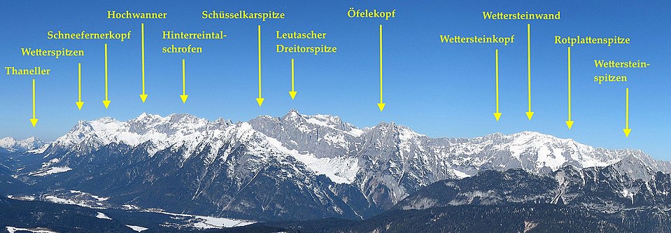
The Hinterreintalschrofen in the Wetterstein main ridge

Individual evidence
- ↑ www.erstersteiger.de
- ^ Stephan Beulke: Wetterstein. 4th, unchanged edition. 1996.
Literature and map
- Stephan Beulke: Wetterstein. A guide for valleys, huts and mountains (= Alpine Club Guide . Series: Northern Limestone Alps. ). Written according to the guidelines of the UIAA. 4th, unchanged edition. Bergverlag Rother, Munich 1996, ISBN 3-7633-1119-X .
- Alpine Club Map 1: 25,000, pages 4/2 and 4/3, Wetterstein and Mieminger Mountains.