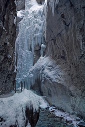
Partnach Gorge
The Partnach Gorge is a 700 meter long gorge in the Reintal near Garmisch-Partenkirchen, which is cut more than 80 meters deep by the Partnach torrent . The bottom of the valley is about 800 m above sea level. NHN in the middle of the gorge. In 1912, the Partnach Gorge was declared a natural monument and has been accessible since then. The path always runs on the right side of the stream.
Geology and formation
In the Middle Triassic , about 240 million years ago, in the area of today's Partnach Gorge, dark gray, relatively hard layers of alpine shell limestone, the so-called sausage limestone or tuber limestone , were deposited on the bottom of a shallow sea . On the bulge-like layers of this rock you can often find traces of burrowing and feeding on the sea creatures of that time. About five million years later, significantly softer marls were deposited in the same sea basin , which are now known as the Partnach layers .
In the course of the later Alpine folding , the so-called Wamberger Saddle arose from these rock layers . The erosion power of the Partnach, fed by the Snowerner on the Zugspitzplatt , was great enough to quickly remove the softer layers, keep pace with the ongoing uplift of the terrain and cut into the hard Alpine shell limestone. Today the river in the area of the Muschelkalk forms the typical narrowly cut valley shape of a gorge , while to the north and south of it in the areas of the softer Partnach layers wider valley shapes predominate.
Geotope
The gorge is designated by the Bavarian State Office for the Environment as Geotope 180R002. In 2002 the Partnach Gorge was awarded the official seal of approval “ Bavaria's most beautiful geotopes ”. See also the list of geotopes in the Garmisch-Partenkirchen district .
Economical meaning
The gorge was already conquered in the 18th century by locals who, at risk of death, transported firewood from the Reintal to Partenkirchen on Trift . From the 18th century until the 1960s, the river and the gorge were used as a Triftbach. In spring, the wood marked with the owner's identification mark , the Hausmarch , was thrown into the stream and transported down to the valley by the meltwater. When loosening wedged tree trunks, men were repeatedly killed. These accidents are evidenced by panels on a cross between the Olympic Stadium and the entrance to the gorge.
The gorge has also been open to tourists since 1912. The gorge can be climbed all year round during the day. An entrance fee has to be paid for this. The Partnach Gorge can be reached very quickly and easily from Garmisch-Partenkirchen; In addition, the path through the gorge is very easy to walk as there are no great differences in altitude to overcome. These circumstances contribute to the fact that the Partnachklamm is one of the most famous and most visited gorges in Germany. During the snowmelt in spring, the gorge can also be closed for a short time.
Rock fall and storms
On June 1, 1991, approx. 5000 m³ of rock broke out of a rock wall at the southern end of the gorge and blocked the previous route and the watercourse. Fortunately, this surprising rock fall did not claim any human life. A small natural reservoir was created and the Partnach made its way around the huge boulders. Since 1992, a 108 m long tunnel blasted into the rock has led past the rock masses and the reservoir. The tunnel is illuminated through windows from which one can safely observe this natural phenomenon.
After heavy storms on 12./13. June 2018 the Partnachklamm was closed until August 4th.
More gorge phenomena
Also in the district of Garmisch-Partenkirchen near Mittenwald is the smaller Leutasch Gorge , partly located in Austria , which has been accessible with an impressive gorge trail since May 24, 2006, the Höllental Gorge near Grainau - Hammersbach and the Schleifmühl Gorge near Unterammergau .
See also
Web links
- Technical information about the gorge from the Bavarian State Office for the Environment (PDF; 206 kB)
- Information on the creation and use of the gorge, as well as a virtual tour
- Photos of the Partnach Gorge from summer and winter and further information
- Operator's website
Individual evidence
- ↑ Geotop: Partnachklamm (accessed on October 12, 2013; PDF; 206 kB)
- ↑ Bavarian State Office for the Environment: Klamm secretly! Partnach Gorge . In: Hundred Masterpieces - The Most Beautiful Geotopes of Bavaria , Augsburg 2012, ISBN 978-3-936385-89-2 , p. 186 f.
- ↑ http://www.partnachklamm.eu/partnachklamm.htm#felssturz
- ↑ Partnachklamm remains closed for weeks. In: sueddeutsche.de. June 15, 2018, accessed June 28, 2018 .
- ↑ Partnach Gorge closed for a long time after severe weather , br.de from June 1, 2018
Coordinates: 47 ° 28 ′ 9 ″ N , 11 ° 7 ′ 7 ″ E


