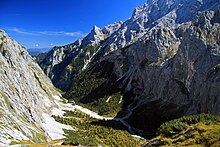
Höllental (Wetterstein)
The Höllental is a valley in the Zugspitze massif of the Wetterstein Mountains between Blassenkamm and Waxensteinkamm , through which the Hammersbach flows and through which a well-known ascent route runs from Hammersbach to the Zugspitze .
The cut of the Höllentalklamm , which squeezes between high rock walls, is striking . The Höllentalangerhütte ( 1387 m ) is the overnight domicile for mountaineers who want to climb Germany's highest peak the following day through the Höllental and over the Höllentalferner .
Before the touristic development at the beginning of the 20th century , the Höllental was particularly important because of its iron ore and molybdenum deposits. However, only ruins of the former mining facilities are visible today.
The touristic development of the gorge began in 1902 under the direction of the engineer Adolf Zoeppritz and a few local mountain guides. On August 15, 1905, the completion of the entire development was celebrated and the Höllentalklamm was officially inaugurated.
Höllentalklamm
Access
From the Grainau district of Hammersbach , a footpath that is around three kilometers long and climbs around 300 meters in altitude leads through an increasingly narrow valley to the Höllental entrance hut and the toll path through the gorge ( 47 ° 26 ′ 55.3 ″ N , 11 ° 2 ′ 37.6 ″ O ). Shortly before the hut, the free, but somewhat more difficult and ½ to ¾ hour longer Stangensteig branches off. This runs above the course of the stream and leads halfway on a high iron bridge over the gorge. Except for the deep view from the bridge, however, the view into the interior of the gorge is largely blocked from here.
Klamm
Starting at the Höllentalklamm entrance hut (where it is actually still called Maximiliansklamm ), the path stretches over 700 m through the imposing gorge. Since 2011 there has also been an opportunity to learn more about the history of the gorge in the Höllentalklamm Museum. From the entrance hut, a great deal of effort has been made to create a safe path that leads largely through tunnels about 1 m wide and a maximum of 2 m high in the rock. The Hammersbach, which is rather inconspicuous outside the gorge, swells into a raging torrent in the very narrow (approximately 2 to 5 m) and high (approx. 150 m) rock gorge. At the upper end of the gorge, the terrain slowly becomes wider again. Beyond the gorge, the path leads to the Höllentalangerhütte , which lies in a sparsely vegetated valley floor covered with gravel.
The gorge has been designated as a valuable geotope by the Bavarian State Office for the Environment (geotope number: 180R018).
Tour possibilities
Various trails branch off at the hut, leading to the Zugspitze , Osterfelderkopf (cattle trail to the Alpspitzbahn ) and Alpspitze (Mathaisenkar) or to other challenging destinations in the Wetterstein Mountains (e.g. Riffelscharte, Riffeltorkopf , Riffelspitzen , Hohe Riffel, Waxenstein , Höllentorkopf and Schwarzenkopf ). An interesting way back from the Höllentalangerhütte to Hammersbach is the already mentioned Stangensteig, which was used by the miners of the former mine.
Zugspitzweg
It was not until 1872 that Georg Winhart from Munich and the Ehrwald leader J. Rauch were the first to descend from the eastern summit of the Zugspitze into the valley. Before that, it was considered impossible to find a way from the summit to the Höllental. However, the path did not lead any further on the insurmountable steep walls that fell from the Höllentalkar into the Höllentalanger. So the two turned to the southeast and reached over the Mitter- and Mathaisenkar to the Knapp houses . In the same year, Tillmetz and Johannes from Munich repeated the opposite route with the Garmisch mountain guide Dengg . Until 1893, this was the only way to climb from the Höllental to the Zugspitze, which was also associated with a significant drop in altitude.
There was still no path through the Höllentalklamm, there was only a path above the canyon. At a point about 30 meters wide and 100 meters deep, the gorge had to be crossed on a primitive footbridge without a railing. The Munich section of the German Alpine Club improved this footbridge as early as 1882/83. However, a foehn storm in 1885 severely damaged this bridge and so the board decided to build a permanent iron bridge. On September 12, 1888, the 5-ton building was completed. The total cost was 3,270 marks.
In order to shorten the ascent route and get directly from the Anger to the Höllentalkar, the Munich Alpine Club section built an artificial transition on a steep face in 1893 with the help of iron clips and steel cables . This section is now known as the "Board" . The section also secured the way from the edge of the Höllentalferner gorge to the summit with steel cables.
See also
literature
- Peter Schwarz: The Höllental molybdenum mine 1907 - 1925; Struggle for a rare commodity ; R. Oldenbourg Verlag; 1992; ISBN 3-486-26265-3
Individual evidence
- ^ Bavarian State Office for the Environment, Geotop Höllentalklamm S von Grainau "SE von Grösdorf (accessed on October 19, 2017).
- ↑ a b c Josef Bindl (Ed.): 80 years of Höllentalhütte . 1894 - 1974. self-published, Munich 1974, p. 6-8 .
Web links
- A new bridge for the Höllentalklamm In: Süddeutsche Zeitung . Online version May 5, 2020, accessed May 5, 2020.
- Information about the Höllentalklamm as well as numerous photos of the gorge
- The lead and molybdenum mine in the Höllental near Garmisch
- Hiking in the Höllentalklamm and Höllental
Coordinates: 47 ° 26 ′ 27.7 ″ N , 11 ° 2 ′ 2 ″ E


