High pale
Not to be confused with the Hochblasse ( 1989 m ) in the Ammergau Alps.
| High pale | ||
|---|---|---|
|
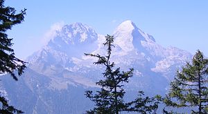
Hochblassen (left) and Alpspitze (right), seen from the Schachen ascent |
||
| height | 2703 m above sea level NHN | |
| location | 8 kilometers south of Garmisch-Partenkirchen, German state Bavaria | |
| Mountains | Northern Limestone Alps ( Wetterstein Mountains , Blassenkamm) | |
| Dominance | 1.82 km → Äusseren Höllentalspitze | |
| Coordinates | 47 ° 25 '20 " N , 11 ° 2' 39" E | |
|
|
||
| First ascent | Hermann von Barth , Peter Klaisl, 1871 | |
| Normal way | North of the Grießkarscharte from | |
The Hochblassen is a little more committed, 2703 m above sea level. NHN high mountain made of Wetterstein limestone in the Wetterstein Mountains . In addition to the main summit, it also has the so-called signal summit with a height of 2698 meters. It was first climbed on August 24, 1871 by Hermann von Barth and the farmer's son Peter Klaisl.
location
The mountain is about 4.5 kilometers east of the Zugspitze . It forms the corner of three ridges: to the west the Höllentalgrat, to the east the Blassengrat, to the north a connecting ridge to the Alpspitze .
To the west, the Höllentalgrat connects the Hochblassen with the Zugspitze and separates the Höllental from the Reintal . The climbing guide known as the Jubiläumsgrat runs over almost the entire Höllentalgrat, but not over the Hochblassen, which is bypassed in its southwestern flank.
To the east, the Blassengrat connects the Hochblassen with the Blassenspitze 2460 m , the Hohen Gaif 2289 m and the Mauerschartenkopf 1924 m . This ridge separates the Grießkar from the Reintal.
Finally, to the north, the Hochblassen is connected to the Alpspitze at 2620 m via the Grießkartscharte 2465 m . The Alpspitze hides the Hochblassen so that it is not visible from Garmisch.
To the north, towards the Grießkar , the mountain has a very steep and rugged wall about 500 meters high. To the south into the Reintal , the walls are over 900 meters high.
Base and ascent
Access points to the Hochblassen are the Höllentalangerhütte ( 1381 m , three hours ascent to the Grießkarscharte), the Kreuzeckhaus or the Osterfelderkopf mountain station 2033 m of the Alpspitzbahn .
Older maps show a via ferrata that branches off the Jubiläumsgrat-Führe and leads on the Höllentalgrat to the summit of the Hochblassen. However, all via ferrata safety devices have now been dismantled.
The easiest ascent leads from the Grießkarscharte (2463 m) south over the connecting ridge between Alpspitze and Hochblassen. This route was first climbed in 1881 and is described today with the difficulty level UIAA II in some places, the ascent over the Blassengrat, however, with UIAA III. On the north and south sides of the mountain there are challenging and serious climbing routes from difficulty level UIAA V upwards.
Literature and map
- Hermann von Barth: From the Northern Limestone Alps. Eduard Amthor, Gera 1874.
- Stephan Beulke: Wetterstein. A guide for valleys, huts and mountains (= Alpine Club Guide . Series: Northern Limestone Alps. ). Written according to the guidelines of the UIAA. 4th, unchanged edition. Bergverlag Rother, Munich 1996, ISBN 3-7633-1119-X .
- Alpine Club Map 1: 25,000, sheet BY 8, Wetterstein Mountains .
Web links
Individual evidence
- ^ Hermann von Barth: From the Northern Limestone Alps. Eduard Amthor, Gera 1874, p. 567 ff.
- ^ Stephan Beulke: Wetterstein. 4th, unchanged edition. 1996, margin no. 670 ff.


