High gaif
| High gaif | ||
|---|---|---|
|
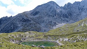
The Hohe Gaif behind the Stuibensee |
||
| height | 2288 m | |
| location | Bavaria , Germany | |
| Mountains | Wetterstein | |
| Coordinates | 47 ° 25 '21 " N , 11 ° 3' 54" E | |
|
|
||
| rock | Wetterstein lime | |
| Age of the rock | Triad | |
The Hohe Gaif is a 2288 m high summit in the Wetterstein Mountains in the Blassenkamm (east ridge of the Hochblassens ).
An ascent is possible from the north from Stuibensee up and over the east ridge of the Hohen Gaif or on the climbing route over the Blassengrat to Hochblassen.
Literature and maps
- Thomas Otto: Munich mountain tours: 46 rock tours in the II degree between Salzburg and Oberstdorf. 1st edition Munich 2012. pp. 128–131. ISBN 3-7633-3050-X , ISBN 978-3-7633-3050-8
- Walter Pause: Munich's local mountains. 6th edition, p. 98
- Alpine Club Map (1: 25,000), BY8, Wetterstein Mountains - Zugspitze
Individual evidence
- ↑ Geological map of Bavaria with explanations (1: 500,000). Bavarian Geological State Office, 1998.
- ^ BayernAtlas [1] .
- ↑ geonames.org

