
Stuiben (Wetterstein)
| Stuiben | ||
|---|---|---|
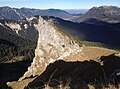
 Stuibenwand, Stuibenspitze and Stuibenkopf. In the background the Wettersteinkopf , Frauenalpl and Dreitorspitze (from left to right). |
||
| height | 1924 m above sea level NHN | |
| location | Germany , Bavaria , Garmisch-Partenkirchen | |
| Mountains | Northern Limestone Alps ( Wetterstein Mountains ) | |
| Coordinates | 47 ° 25 '28 " N , 11 ° 4' 45" E | |
|
||
| rock | Raibler layers | |
| Age of the rock | Triad | |
| Normal way | from the north (Berna Your riser) on the Stuibenhütte past | |

The Stuiben is a north-south oriented mountain ridge in the Wetterstein Mountains in Bavaria . It slopes rocky and steep to the west into the Gassental ( Stuibenwand ), while the eastern flank has less steep meadows and pine slopes , which are used as alpine pastures in summer. In the south, the Stuiben ends with two peaks: the striking Stuibenspitze (1908 m) and the rather inconspicuous, but somewhat higher Stuibenkopf at 1924 m . To the south, the Stuiben at the Mauerschartenkopf (1919 m) borders the west-east-oriented Blassengrat . The Stuibenhütte is located at the northern foot of the Stuiben .
The summits of the Stuiben can be climbed easily from the north, but mostly without paths over meadow slopes; in summer as a hike, in winter as a ski tour. Over the Stuibenkopf one arrives over the Schützensteig down into the Reintal .
gallery

Stuibenkopf seen from the Wallerschartenkopf. In the back left the Bernadeinkopf .
Stuibenspitze seen from the Stuibenkopf. In the background v. l. No. Ammer Mountains , Loisachtal , Starnberger See and Ester Mountains .
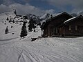
View from the Stuibenhütte to the Stuibenspitze (left).


Web links
Individual evidence
- ↑ Federal Institute for Geosciences and Raw Materials, Geological Overview Map 1: 200000