Gehrenspitze (Wetterstein)
| Miter tip | ||
|---|---|---|
|
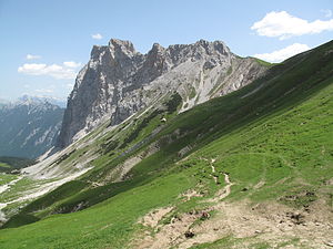
Summit from the northwest |
||
| height | 2367 m above sea level A. | |
| location | Tyrol , Austria | |
| Mountains | Wetterstein Mountains | |
| Dominance | 1.6 km → Schüsselkarspitze | |
| Notch height | 319 m ↓ Scharnitzjoch | |
| Coordinates | 47 ° 23 '12 " N , 11 ° 8' 6" E | |
|
|
||
| Normal way | From Leutasch via Scharnitzjoch, mountain tour | |
|
Gehrenspitze from the east |
||
The Gehrenspitze is a mountain in the eastern part of the Wetterstein Mountains in Tyrol . It reaches a height of 2367 m above sea level. A.
Location and surroundings
The Gehrenspitze is in front of the Wetterstein main ridge above the Leutasch to the south. It is separated from the main ridge by the 2048 m high Scharnitzjoch . The 500 meter high steep north face falls into via Puittal Valley , while on the south flank in the summit area steep grassy slopes and craggy ground and below extended Latsch belt predominate.
Bases and paths
Starting points for an ascent are the Leutasch districts of Gasse in the southeast and Klamm in the southwest. The bases are the Wettersteinhütte ( 1717 m ) and the Wangalm ( 1753 m ) in the west. The memorial hut of the Academic Alpine Club Munich ( 2083 m ) above the Scharnitzjoch is not open to the public.
The usual ascent to the summit runs over the west ridge (or mostly on its southern flank, good marked trail). From Scharnitzjoch past the memorial hut and further east to the summit. The Scharnitzjoch can be reached either from Leutasch-Klamm via Wettersteinhütte or Wangalm or through the Puittal. A second ascent leads from the southeast (Leutasch-Gasse) through a prominent rubble channel (“Nazenlehn”) that runs through the southern flank, and over the east ridge to the summit. This route, once a marked trail with climbing points of difficulty I (UIAA) , is now considered to be difficult to walk.
Climbing routes in difficulty range III-V lead through the north face , which, however, are very seldom used because of the great fragility and danger of falling rocks.
literature
- Stephan Beulke: Wetterstein. A guide for valleys, huts and mountains (= Alpine Club Guide . Series: Northern Limestone Alps. ). Written according to the guidelines of the UIAA. 4th, unchanged edition. Bergverlag Rother, Munich 1996, ISBN 3-7633-1119-X , pp. 446-448.
- Alpine Club Map : 4/3 Wetterstein and Mieminger Mountains, Eastern Leaf (1: 25,000). 2005
Individual evidence
- ↑ Remembrance Hut (2083 m) , accessed on November 11, 2018.
- ↑ a b Stephan Beulke: Wetterstein. 4th, unchanged edition. 1996, pp. 446-448.
- ^ Mark Zahel: Tyrol - Oberinntal. Stubai - Ötztal - Ausserfern - Arlberg. 50 tours between Innsbruck and Arlberg. Bergverlag Rother, Munich 2011, ISBN 978-3-7633-3056-0 , p. 31, Google Books .


