
Rohrach (Iller)
| Rohrach | ||
 Steep walls in the gorge near Altusried-Staubers |
||
| Data | ||
| Water code | DE : 114578 | |
| location | Bavaria , Germany | |
| River system | Danube | |
| Drain over | Iller → Danube → Black Sea | |
| source | at Wiggensbach 47 ° 44 ′ 2 ″ N , 10 ° 13 ′ 21 ″ E |
|
| Source height | 930 m above sea level NN | |
| muzzle | at Legau -Fluhmühle in the Iller coordinates: 47 ° 50 '25 " N , 10 ° 11' 31" E 47 ° 50 '25 " N , 10 ° 11' 31" E |
|
| Mouth height | 622 m above sea level NN | |
| Height difference | 308 m | |
| Bottom slope | 19 ‰ | |
| length | 15.8 km | |
| Left tributaries | Sägemühlbach , Kochtobelbach , Singerstobelbach | |
| Right tributaries | Winnebergbach | |
 Weir at the Staubers |
||
The Rohrach is an approximately 15.8 km long, left or southern tributary of the Iller in the districts of Upper and Lower Allgäu in Bavaria .
course
The Rohrach rises on the eastern edge of the Kürnach Forest around 700 m northeast of the Dürrer Bichl mountain (also called Dürrer Bühl ; around 1077 m above sea level ) or around 500 m north-northwest of the Blender mountain ( 1072.3 m above sea level ). Its source is south of the Wiggensbach hamlet of Staudach . Below its origin it forms the small Rohrachklamm with steep slopes and rock faces.
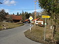
On its way north-north-west, the Rohrach crosses - apart from the Wiggensbach located on the upper reaches - in particular agricultural areas, wet meadows and forests. On its last kilometer the brook forms the border between the districts of Oberallgäu and Unterallgäu. North of the Fluhmühle hydropower station , the Rohrach flows into the Danube tributary Iller .
Water wheels
Once upon a time, almost twenty waterwheels turned on the banks of the Rohrach, providing power for sawmills, grain mills and bone pounding mills.
photos
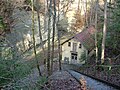
E-Werk in the gorge
Sawmill in Staubers

