Herrenwieser Weiher
| Herrenwieser Weiher | ||
|---|---|---|

|
||
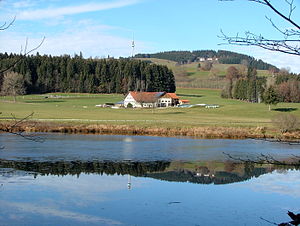
| Herrenwieser Weiher, view to the west to the wasteland of Herrenwies (municipality of Wiggensbach ), in the background the Blender with the telecommunications tower . | ||
| Geographical location | Kempten (Allgäu) , Bavaria | |
| Tributaries | unnamed stream | |
| Drain | Kleine Rottach → Rottach → Iller | |
| Data | ||
| Coordinates | 47 ° 42 '58 " N , 10 ° 15' 13" E | |
|
|
||
| Altitude above sea level | 787.24 m above sea level NN | |
| surface | 6.4 ha | |
| length | 475 m | |
| width | 195 m | |
| volume | 118,800 m³ | |
| scope | 1.77 km | |
| Maximum depth | 4.7 m | |
| Middle deep | 1.8 m | |
| Catchment area | 8.57 km² | |
The Herrenwieser Weiher is a lake in Kempten (Allgäu) and the largest still water in the city in terms of area. It forms the western boundary of the Mariaberg ridge . Centuries ago, the pond was artificially dammed as part of the Kempten water supply and as a fishing water. Today it is a popular swimming lake.
The lake is located on the southwestern city limits near the hamlet of Hinteregg . The eponymous Einödhof Herrenwies already belongs to the neighboring municipality of Wiggensbach . In the past, the Kempten – Isny railway ran past the lake, today it is the Allgäu cycle path . The former embankment is used both as a bike and hiking trail. The lake is 787.24 m above sea level. NN . The area is 6.4 (according to other information 6.6) hectares . The lake is on average 1.8 meters and a maximum of 4.7 meters deep. Its catchment area, artificially expanded, measures 8.57 km².
The Herrenwieser Weiher was first mentioned in 1769 and was part of the early long-distance water supply in Kempten . From the Herrenwieser Weiher the water flows over partly artificial canals to the Kemptener Stadtweiher , another dammed lake of the so-called Schlangenbach system.
The Herrenwieser Weiher used to belong to the municipality of Sankt Lorenz , which was incorporated into Kempten in 1972. However, the area around the lake was separated from Sankt Lorenz and incorporated into Kempten on April 1, 1935.
Until 2003 the landowner of the Herrenwieser Weiher was the city of Kempten (Allgäu). This year the body of water was taken over by the association for recreation areas in Kempten and Oberallgäu .
Individual evidence
- ↑ Bruno Steinmetz: Der Schlangenbach ... In: Altstadtbrief 1999 ( online , accessed on February 20, 2013)
- ^ City of Kempten - Herrenwieser Weiher , accessed on February 21, 2013
- ↑ Bathing water profile according to § 6 of the Bavarian Bathing Water Ordinance, created on: February 24th, 2011 (PDF; 53 kB)
- ↑ Jan Seele: Ecological assessment of small pre-alpine lakes based on diatoms, macrophytes and the use of their catchment areas. Dissertation, Technical University of Munich, 2000 ( Memento of the original dated July 22, 2004 in the Internet Archive ) Info: The archive link was inserted automatically and has not yet been checked. Please check the original and archive link according to the instructions and then remove this notice. , P. 28
- ^ Siegfried Neukamm - Herrenwieser Weiher
- ↑ Bruno Steinmetz: The Schlangenbach should remain visible. In: The Old Town Letter , No. 26/1999 , p. 4
- ↑ Zweckverband Kempten and Oberallgäu recreational areas, history
