
Kempten – Isny railway line
| Kempten (Allg) Hbf – Isny | |||||||||||||||||||||||||||||||||||||||||||||||||||||||||||||||||||||||||||||||||||||||||||||||||||||||||||||||||||||||||||||||||||||||||||||||||||||||||||||||||||||||||||||||||
|---|---|---|---|---|---|---|---|---|---|---|---|---|---|---|---|---|---|---|---|---|---|---|---|---|---|---|---|---|---|---|---|---|---|---|---|---|---|---|---|---|---|---|---|---|---|---|---|---|---|---|---|---|---|---|---|---|---|---|---|---|---|---|---|---|---|---|---|---|---|---|---|---|---|---|---|---|---|---|---|---|---|---|---|---|---|---|---|---|---|---|---|---|---|---|---|---|---|---|---|---|---|---|---|---|---|---|---|---|---|---|---|---|---|---|---|---|---|---|---|---|---|---|---|---|---|---|---|---|---|---|---|---|---|---|---|---|---|---|---|---|---|---|---|---|---|---|---|---|---|---|---|---|---|---|---|---|---|---|---|---|---|---|---|---|---|---|---|---|---|---|---|---|---|---|---|---|---|
 | |||||||||||||||||||||||||||||||||||||||||||||||||||||||||||||||||||||||||||||||||||||||||||||||||||||||||||||||||||||||||||||||||||||||||||||||||||||||||||||||||||||||||||||||||
| Route number (DB) : | 5401 | ||||||||||||||||||||||||||||||||||||||||||||||||||||||||||||||||||||||||||||||||||||||||||||||||||||||||||||||||||||||||||||||||||||||||||||||||||||||||||||||||||||||||||||||||
| Course book section (DB) : | 972, 1944: 404 e | ||||||||||||||||||||||||||||||||||||||||||||||||||||||||||||||||||||||||||||||||||||||||||||||||||||||||||||||||||||||||||||||||||||||||||||||||||||||||||||||||||||||||||||||||
| Route length: | 37.556 km | ||||||||||||||||||||||||||||||||||||||||||||||||||||||||||||||||||||||||||||||||||||||||||||||||||||||||||||||||||||||||||||||||||||||||||||||||||||||||||||||||||||||||||||||||
| Gauge : | 1435 mm ( standard gauge ) | ||||||||||||||||||||||||||||||||||||||||||||||||||||||||||||||||||||||||||||||||||||||||||||||||||||||||||||||||||||||||||||||||||||||||||||||||||||||||||||||||||||||||||||||||
|
|||||||||||||||||||||||||||||||||||||||||||||||||||||||||||||||||||||||||||||||||||||||||||||||||||||||||||||||||||||||||||||||||||||||||||||||||||||||||||||||||||||||||||||||||
The Kempten – Isny railway line - also popularly known as Isny-Bähnle or Kempter Zügle - was a branch line in Bavaria and Baden-Württemberg . It ran from Kempten (Allgäu) via Sibratshofen to Isny im Allgäu . It was opened on October 14, 1909 and closed almost 75 years later on September 29, 1984. A 3.81-kilometer-long remnant within the urban area of Kempten was also served by freight traffic until February 1, 1992 .
Building history
The beginnings of the route go back to a publication in the Allgäuer Zeitung on December 21, 1895, in which the royal building officer Josef Widmann from Weitnau outlined the later route. His good relations with the Bavarian government in Munich and a similar initiative by an Isny committee in Stuttgart advanced the project. In 1905, the construction project was specified in a state treaty between the two kingdoms of Bavaria and Württemberg. Compared to the relatively long planning phase of over ten years, however, the realization took place in a relatively short time between June 1907 and October 1909, the construction costs amounted to 2,981,000 marks . The Sibratshofen – Isny section was not built by the Royal Bavarian State Railways , but by the Royal Württemberg State Railways , although the actual state border only cut the route just under four kilometers north of Sibratshofen. As a special feature, the Kleinweiler-Hofen station on Bavarian territory was built in the typical Württemberg architectural style, similar to the neighboring Großholzleute station. Over the years, various industrial companies have settled along the route. These include the Allgäu soap and soda factory , the iron processing companies Gustav Möldner & Söhne and Kemptener Eisengiesserei Adam Hönig , the Grünwald cheese factory , the Patzer peat factory and the Adolff bobbin factory . They all had their own siding .
Route
The route runs through the scenic southern and western Allgäu . From the main train station in Kempten, the route climbs up curvy and follows the valley of the Westallgäu Rottach. The average gradient of 25 per thousand is comparatively high for adhesive sheets. After overcoming an altitude difference of 232 meters, it passed the European main watershed between the Danube and the Rhine , this point at an altitude of 937.90 meters was the highest point in the German standard gauge network at the time of opening. The neighboring Hellengerst station at a height of 926 meters was the highest station of the Deutsche Reichsbahn until the opening of the Dreiseenbahn in 1926 . Then it went first through the Weitnau valley and then downhill again through the Argental . The line finally ended in the small town of Isny, where there was a connection to the trains on the Herbertingen – Isny line until 1969, and thus to other destinations in the Württemberg Allgäu. In Isny, the two lines shared a common terminus , and they ran in the direction of Isny on the last section over a length of around 750 meters on a common route.
business

- The Kempten – Sibratshofen section was subordinate to the Augsburg Railway Directorate, the rest of the route to the Stuttgart Railway Directorate.
- Steam locomotives were used on the line until the early 1960s , including first the 98 and 91 series and later the more modern 86 and 64 series . At the time of steam operation, the travel time over the entire route was two and a quarter hours, as water had to be drawn in Kürnach and Weitnau. Afterwards, diesel locomotives and Uerdingen rail buses ran for a while . In the last years of operation finally came in depot stationed Kempten and then ultra-modern diesel railcars - prototypes of series 627 and 628 on the route used. First from 1974 the series 627.0 and 628.0, from 1981 then finally also the successor series 627.1 and 628.1.
- In the last few years of operation, train crossings took place at Ermengerst station . The station was unmanned, the driver of the train arriving first was responsible for the correct setting of the switches ( train control operation ).
- The section between Ermengerst and Hellengerst was considered particularly dangerous by drivers, as it ran long distances through dense forests and had a large number of unsecured, level crossings with forest roads and a relatively high volume of timber truck traffic. Passengers were therefore not allowed to stay on the open platforms of the cars on this section.
- The Rotenbach (b Isny) stop was only opened in 1937 and given up again in 1961 due to the low demand. The four breakpoints Aheggmühle , Herrenwieser Weiher (an emergency stop that was often used by bathers, especially in summer), Tobelmühle and Leutfritz were also subsequently set up . They went into operation in 1951 and mainly served tourist purposes, the Tobelmühle stop was closed again in 1963.
- With the start of the winter timetable on September 28, 1969, the new main train station in Kempten went into operation, and since then passengers have had to walk 1000 meters longer to and from the city center. This led to the route becoming less attractive. In return, however, the transfer situation to the through express trains to Munich , Lindau , Ulm and Oberstdorf improved . Before 1969, these trains only stopped at the Kempten-Hegge suburban station, bypassing the old main station.
Setting and conversion to bus transport
Ultimately, the rationalization achieved through the use of modern railcars , the so-called one-man operation, could not save the Kempten – Isny line from being closed. In particular, the complex routing necessary to gain height and the routing away from the settlements - in an already sparsely populated region - ultimately became the railway's undoing. In the eyes of those responsible, train traffic was no longer competitive with the bus traffic that was envisaged. As a result, the line has not been modernized in recent years - with the exception of the new vehicles. In addition, the plans for the so-called Bundesstraße 12 were new . It should run between Weitnau and Großholzleute partly on the level of the railway line and it should also cross between Schwarzerd and Hellengerst.
The deciding factor for the first setting was the ailing bridge over the Argen. It had to be blocked immediately due to its dilapidation, which was also a result of neglected maintenance measures. The Sibratshofen – Isny section was therefore shut down on April 18, 1983 - in the middle of the current timetable period. At that time, 14 years after the suspension of passenger traffic to Leutkirch, Isny also lost its second rail connection. The operation of the passenger traffic between Sibratshofen and Isny took over from now on rail buses in the rail replacement traffic , in Sibratshofen had to be changed.
Because this remaining operation with the obligation to change trains was even more unattractive and uneconomical, the rail traffic between Kempten and Sibratshofen was also discontinued with the start of the winter timetable on September 30, 1984. Only a short remaining section to the connection of Wollwaren Möldner and Eisengießerei Hönig lasted a little longer. This was still used in freight traffic until February 1, 1992 and was finally abandoned on the occasion of the widening of Oberstdorfer Strasse ( Bundesstrasse 19 ).
Dismantling the track system and setting up a cycle path
In April 1986, using the track dismantling process using a special crane and dismantling train, 30 km of rails including sleepers were dismantled from the Argen Bridge near Isny to Kempten- Steufzgen (at the level of the Kempten-West substation). The track dismantling went exactly according to plan: work began on April 1st, around the clock, even on Sundays and public holidays - and in just under four weeks the track was gone. On April 26, 1986, the five-arched railway bridge at Ahegg was blown up. From the Argen Bridge to Isny, rails and sleepers were individually dismantled in 1988/89 with the help of an excavator. From Steufzgen to Kempten, the line was maintained until May 1991 because Möldner and Hönig were still dependent on this siding. This last section was finally dismantled from September to December 1991, including parts of the railway embankment and the bridge over Oberstdorfer Straße.
From 1990 onwards, large parts of the route were expanded into what has become a very popular foot and cycle path , but this is mostly only gravel. The path became an essential part of the Allgäu cycle path .
The first section to be developed is a 600 meter long asphalt section in the urban area of Kempten, but it is only of local importance. The second section (not asphalted) is around 800 meters long, starts shortly before the former Steufzgen station (a historic bus shelter was built here in May 2010) and ends at the level of the former factory entrance of the Möldner and Hönig companies. The third section (not asphalted) is 3.4 kilometers long, it begins shortly after the Rothkreuz station at the time at the Hochland cheese dairy and leads to Ermengerst station. The fourth and longest contiguous stage of the cycle path (length: 8.6 kilometers - not asphalted) begins here at the former level crossing over the district road OA 15 (Römerstraße), it ends shortly after the watershed between the Danube and the Rhine . After a break of 600 meters (due to the construction of the B 12 new ), another 6.6 km long section (also not asphalted) follows, which begins at the former Hellengerst stop and ends at the eastern edge of the community of Weitnau. The sixth and last section developed as a cycle path (length: 2.5 kilometers) is again paved and leads completely along the federal highway 12. It begins between Sibratshofen and the Klausenmühle and ends north of the former train station Kleinweiler-Hofen, immediately before the former railway bridge the Wengener Argen.
Cross-country ski run
In winter, a section of the high-altitude Schwarzerd– Buchenberg route is used as a groomed cross - country ski trail , it is part of the so-called Danube-Rhine trail including the branch to the Sommerau. This trail is about five kilometers long in total, it ends or starts in Buchenberg and is skied clockwise.
Relics of the railway
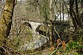
In addition to most of the route itself, most of the mostly wooden station buildings of the railway have been preserved, some of which are now used as bus stops. Only the station buildings in Kürnach and Sibratshofen were demolished. The station Ermengerst is not doing more in its original location, he was gutted several years ago and using a mobile crane offset by approximately 200 meters to the west. Residential houses were built on the original station site. The Rottach Bridge at 4.6 km , the Rottach Bridge near Ahegg at 6.4 km and the Argen Bridge at 33.8 km have also been preserved. In return, however, the bridge over the State Road 2376 at km 6.3 and the Rottach Bridge at km 6.6 were replaced by modern, lightweight bridges for pedestrian and cycle paths in the 1990s. Remnants of track can still be found in the following places:
- between hardware store Hornbach and discounter Aldi (Kempten)
- at the former Rothkreuz stop (Kempten)
- on the bridge over the Argen
- at the former stop at Rotenbach
- at the former Bettmauer level crossing
In addition, some street names are reminiscent of the railway, including the Bahnweg in Ermengerst, the streets Am Bahnhof in Buchenberg and Am Bahnhof in Weitnau, the Bahnhofweg in Großholzleute and the Bahnhofstraße in Isny.
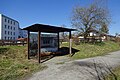
Bus shelter Steufzgen (2015)

Obtained milestone
Railway bridge over the Rottach (2015)

Rothkreuz stop (2015)
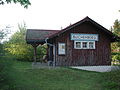
Former station building in Buchenberg
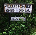
The Rhine-Danube watershed at a height of 937.90 meters above sea level was the highest point on the route

Bus shelter Hellengerst (2015)

Former station building in Großholzleute

At the former Großholzleute train station

Railway bridge over the Argen (2015)

Bettmauer level crossing (2013)
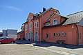
Former Isny station building - track side
.jpg)

.jpg)
.jpg)


.jpg)


.jpg)
.jpg)

various
After the railway was closed, a private entrepreneur temporarily planned to set up a tourist narrow-gauge railway on the approximately three-kilometer section between Isny and the quarry pond south of the Rotenbach stop . To this end, he kept rails, sleepers, switches and locomotives on the grounds of the Isny train station for a number of years, but ultimately the plans could not be implemented.
Large parts of the movie Waller's last course by Christian Wagner were shot on this railway line in 1988 - immediately before the track system was dismantled (but also on the neighboring Herbertingen – Isny line, on the Staudenbahn and on the Allgäu section of the Ausserfernbahn ).
literature
- Peter-Michael Mihailescu, Matthias Michalke: Forgotten railways in Baden-Württemberg . Konrad Theiss Verlag, Stuttgart 1985, ISBN 3-8062-0413-6 , p. 223-225 .
Web links
- vergöse-bahnen.de: condition of the route in May 2007 at www.vergessene-bahnen.de
- achim-bartoschek.de: Railroad cycling - illustrated description of the cycle path (October 2007)
- Course book 1944: the timetable table 404 e
- Drehscheibe-online.de: Multi-part photo series about the demolition of the route
- Drehscheibe-online.de: Pictures from the last years of operation