
Schmidsreute
|
Schmidsreute
Wiggensbach market
Coordinates: 47 ° 44 ′ 21 ″ N , 10 ° 12 ′ 5 ″ E
|
|
|---|---|
| Height : | 981 m |
| Postal code : | 87487 |
| Area code : | 08370 |
 Location of the hamlet Schmidsreute in the western municipality of the Wiggensbach market
|
|
Schmidsreute is a district of the market Wiggensbach in the Bavarian-Swabian district of Oberallgäu .
The hamlet with nine residential houses and several agricultural buildings is located eight kilometers west of the regional center of Kempten (Allgäu) as the crow flies and a little more than two and a half kilometers west of the main town of Wiggensbach. The Schmidsreute hiking car park is often used as a starting point for hikes to the Blender , in the Kürnacher Wald and in the Adelegg . In Schmidsreute there is a chapel where a church service took place every two weeks during the summer months.
In the more recent past, Schmidsreute was of central importance for the surrounding hamlets through a primary school , which taught from 1853 to 1968 and which then fell to Wiggensbach, and a cooperative cheese dairy, operated from 1905 to 1962.
Geographical location
The St. Rita chapel in Schmidsreute is 981 m above sea level. NN on a ridge that connects to the north-west of the Blender (1,072 m) and the Dürren Bichl (1,077 m) and later merges into the Hohentanner Forest . West and southwest, the closing Kürnachtal and up to 1,129 meters high Kürnacher Forest at.
history
Schmidsreute was first mentioned in 1346 under the name Schmitzrüti or on the Schmidsrytin . These names are interpreted as a reference to the clearing of a blacksmith on the Nesselberg . It is unknown whether the job title was blacksmith or family name. The name Nesselberg, which is no longer in use , probably referred to the southern part of today's Schmidsreute.
In 1853 a single-class school was built as a one-story building and expanded in 1891 by adding one floor.
A cooperative dairy was built in 1905. The milk from the surrounding farms was processed in it. The dairy was in operation with the last twelve members of the cooperative until 1962.
Today's St. Rita Chapel in Schmidsreute was built in 1948/50 instead of an abandoned chapel further west and is a listed building. In 1968 the elementary school, jokingly referred to as "Hochschule Schmidsreute" due to its altitude, was closed. At times more than 40 students were taught, who in winter could often only reach the house on skis or horse-drawn sleighs.
In 1996, an 87 meter high wind turbine with an output of one megawatt (designation Nordex N54 ) was built. As long as it stood, it was controversial due to the very short distance to residential buildings (only approx. 250 meters) and, according to the current distance regulations, would not have been approved. In 2000, at the instigation of the Bavarian State Office for Environmental Protection, a long-term noise emission measurement was carried out. The wind turbine was dismantled in November 2014.
In the spring and summer of 2013, the road that opens up the chapel, the northern part of Schmidsreute and the neighboring hamlets of Stoffels and Burgstall , was completely renovated on the existing route.
gallery
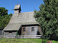
The Schmidsreute chapel
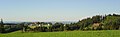
Panorama from Schmidsreute
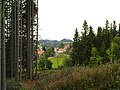
Schmidsreute


literature
- Contributions to the history of the Wiggensbach market , September 30, 1979
- Johannes Goldner: Wiggensbach, an Allgäu homeland book. Market Wiggensbach 1982
- 10 years of the new school in Wiggensbach - Festschrift for the anniversary, 1989
Web links
- Press release of the Federal Association of Landscape Protection ( Memento from July 30, 2004 in the Internet Archive ) from March 4, 2001 (in the Internet Archive ), PDF file (73 kB)
- Ice accumulation and shedding of the Schmidsreuter wind turbine; private website with pictures