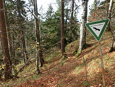
Rohrbachtobel in the Wirlinger Forest
| Rohrbachtobel in the Wirlinger Forest | ||
|---|---|---|
|
|
||
|
|
||
| Location: | Bavaria , Germany | |
| Next city: | Buchenberg , Waltenhofen | |
| Surface: | 0.135 km² | |
| Founding: | December 28, 1959 | |
|
|
||
The Rohrbachtobel area in the Wirlinger Forest is a nature reserve (NSG number 700.09) designated by ordinance of December 28, 1959 in the area of the Bavarian communities Buchenberg and Waltenhofen in the Oberallgäu district in Germany .
location
The approximately 14 hectare Rohrbachtobel nature reserve in the Wirlinger Forest is part of the Iller-Vorberge natural area . It is located south of the center of Buchenberg and west of Waltenhofen at an altitude of around 780 m above sea level. NN and 860 m above sea level NN .
Protection purpose
An essential purpose of protection is to maintain the deep into the layers of the lower Freshwater cut ravine with its steep slopes which have a natural forest vegetation and are floristically significant. Vegetation units worthy of protection are the brook-alder-ash and forest goat's-beard-alder-ash forest and forms of the woodruff (fir) beech forest.
Flora and fauna
flora
From the flora worthy of protection the following plant species (selection) are to be named:
- European yew ( Taxus baccata ), the only European species in the yew genus .
- Fly ragwort ( Ophrys insectifera ), a member of the orchid family .
- Yellow lady's slipper ( Cypripedium calceolus ), one of the most magnificent wild orchids in Europe.
- Red forest bird ( Cephalanthera rubra ), also a member of the orchid family.
- Turk's Union ( Lilium martagon ), from the lily family.
fauna
The following species (selection) from the fauna worthy of protection are to be named:
- Alpine salamander ( Salamandra atra ), a black-colored, country living species of salamanders .
- Great spotted woodpecker ( Dendrocopos major ), a species of the woodpecker family .
- Kingfisher ( Alcedo atthis ), also known as the "flying jewel".
- Mountain wagtail ( Motacilla cinerea ), a songbird from the family of stilts and pipiters .
- Bullhead ( Cottus gobio ), a small, predominantly nocturnal bottom fish.
- Black woodpecker ( Dryocopus martius ), a member of the subfamily of the real woodpeckers .
- Dipper ( Cinclus cinclus ), the only representative of the dipper family to be found in Central Europe .


