
Heckmair route (mountain bike route)
| Heckmair route | |
|---|---|
| overall length | 312 km |
| location |
|
| Starting point | Oberstdorf |
| Target point | Riva |
| Places along the way | Klosters , Livigno , Bormio , Ponte di Legno |
| Flooring | mostly alpine gravel, scree, beaten paths |
| Height difference | 13500 m |
| difficulty | difficult, many pushing and carrying passages, hardly any signposted |
| Traffic volume | only in the valleys |
| Connection to | Iller cycle path , Inn cycle path |
| Website URL | Heckmair route |
The Heckmair route is a non-signposted mountain bike route from Oberstdorf to Riva ( Lake Garda ). Due to the high alpine route, the route is only passable in the summer months.
history

The Heckmair route was developed in 1989 by Andreas Heckmair and published in the mountain bike magazine Bike . It is considered the first alpine crossing by mountain bike . It leads in a straight line, avoiding motorways, on old mule tracks across the Alps. It overcomes an altitude difference of 13,500 meters over a distance of 312 kilometers. Heckmair describes the route as a tour that is spread over five days.
Andreas Heckmair is the son of Anderl Heckmair , who laid the Heckmair route (mountain tour) on the Eiger north face , which should not be confused with the mountain bike Heckmair route.
Six years later, the Joe route was developed as a variant of the Heckmair route as a transalp tour for mountain bikes, which - partly parallel to the route from 1989 - also leads from Oberstdorf to Riva del Garda, but is 120 kilometers longer and altogether more vertical meters having. Since then, other variants have been developed; an entire Transalp modular system was created in which route modules can be completed independently, with the help of digital maps, to create a complete route. At the beginning of all these routes, which are now used by over 10,000 mountain bikers every year, there was the basic idea of Andreas Heckmair: " Ötzi was on foot, Hannibal with elephants, Paulcke with skis, but nobody on a mountain bike." His goal was then : "I wanted to cross the Alps on old mule tracks and as directly as possible."
Route description


1st stage: Oberstdorf - Freiburger Hütte
- Length: 49 kilometers
- Altitude difference: 1,600
- Route: Oberstdorf (820 meters) - Rappenalptal - Schrofenpass (1,687 meters) - Lech - Formarintal - Freiburger Hütte
2nd stage: Freiburger Hütte - Klosters
- Length: 56 kilometers
- Altitude meters: 2,350
- Route: Freiburger Hütte - Raues Joch - Dalaas - Kristbergsattel - Gargellen - Valzifenztal - Schlappiner Joch (2,202 meters) - Klosters
3rd stage: Klosters - Livigno
- Length: 45 kilometers
- Altitude difference: 2,385
- Route: Klosters - Davos - Dürrboden - Scalettapass (2,606 meters) - Val Susauna - Val Chachauna - Chachaunapass (2,694 meters) - Val Federia - Livigno
4th stage: Livigno - Ponte di Legno
- Length: 83 kilometers
- Altitude difference: 1,863
- Route: Livigno - Alpisella Pass (2,260 meters) - Lago di Cancano - Torri di Fraele - Bormio - Gaviapass (2,661 meters) - Ponte di Legno
5th stage: Ponte di Legno - Condino
- Length: 86 kilometers
- Altitude difference: 1,873
- Route: Ponte di Legno - Edolo - Cedegolo - Valle - Passo di Campo (2,288 meters) - Lake Malga Bissina - Daone - Condino
6th stage: Condino - Riva del Garda
- Length: 38 kilometers
- Altitude meters: 1,601
- Route: Condino - Storo - Tremalzopass (1,974 meters) - Pregasina - Riva (66 meters)
photos

Ascent to the Schrofenpass

Protection on the exposed Schrofenpass at the end of the Rappenalptal

Bicycles at the Freiburger Hütte in the Lechquellen Mountains

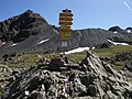
Schlappiner Joch in the border area between Vorarlberg and Graubünden
Scalettapass in the border area between Prättigau and Engadin
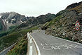
Departure from the Gavia Pass

.jpg)


Literature and maps
literature
Achim Zahn: Alpencross Ostalpen - With the mountain bike across the Alps Bruckmann Verlag, Munich 2011, ISBN 978-3-7654-5397-7 .
cards
The following map set is recommended for the drive:
Compass hiking maps 1: 50,000:
- No. 3 Allgäu Alps, Kleinwalsertal,
- No. 32 Bludenz,
- No. 71 Adamello,
- No. 72 Ortler,
- No. 102 Lago di Garda,
- No. 103 Brescina
National maps of Switzerland :
- No. 248 Prättigau,
- No. 258 Bergün,
- No. 259 furnace pass.
Web links
- Description of the Heckmair route (PDF; 579 kB) by Andreas Heckmair
- Unofficial homepage for the Heckmair route
- GPS data of the Heckmair route
- MTB-Transalp - outdooractive.com: From Oberstdorf to Riva on the classic Heckmair route
Individual evidence
- ↑ Transalp - Heckmair route. on: transalp-veranstalter.de , June 14, 2011.
- ↑ a b The Heckmair route: information on the first crossing of the Alps. on: mountainbike-magazin.de
- ↑ Transalp: The original route from 1990. on: bike-magazin.de
- ↑ Quotation in: Achim Zahn Alpencross Ostalpen - With a mountain bike across the Alps Bruckmann Verlag, Munich 2011, ISBN 978-3-7654-5397-7 , p. 5