
Geiersberg (Spessart)
| Geiersberg
(Breitsol)
|
||
|---|---|---|
 View from the northwest over Weibersbrunn to the Geiersberg |
||
| height | 586 m above sea level NHN | |
| location | between Bischbrunn and Weibersbrunn ; Counties Main-Spessart and Aschaffenburg ; Bavaria ( Germany ) | |
| Mountains | Spessart | |
| Dominance | 48 km → Dreistelzberg ( Brückenauer Kuppenrhön ) | |
| Notch height | 206 m ↓ 3.2 km NE Laufach | |
| Coordinates | 49 ° 54 '22 " N , 9 ° 25' 48" E | |
|
||
| particularities | - highest mountain in the Spessart - broadcaster Breitsol |
|

The Geiersberg , also called Breitsol , is 586 m above sea level. NHN the highest mountain in the Spessart . It is located between Bischbrunn and Weibersbrunn in the Bavarian districts of Main-Spessart and Aschaffenburg . The Breitsol transmitter is located on the wooded mountain .
geography
location
The Geiersberg is located in the Bavarian Spessart Nature Park . Its summit is 6 km northwest of Bischbrunn with the Bischbrunner Forest (Main-Spessart district) and 5.2 km southeast of Weibersbrunn with the non-parish Rohrbrunner Forest (Aschaffenburg district). To the north-northwest the landscape of the Geiersberg leads to the Geierskopf ( 549 m ) 1.5 km away .
Natural allocation
The Geiersberg belongs in the natural spatial main unit group Odenwald, Spessart and Südrhön (No. 14) and in the main unit Sandstone-Spessart (141) to the natural area Southeastern Sandstone Spessart (141.3).
Mountain height
The flat arched summit region of the Geiersberg has two barely noticeable hills: the north-north-east hill with the mountain summit ( 586 m ) and summit cross, over which a farm road leads, and the 400 m further away from it, the south-south-west hill 585.7 m , which is close to the same path the towers of the broadcaster Breitsol.
Flowing waters
On the relatively steep eastern slope of Mount Vulture the entfließt Metz wells on 457 m height of Metz Bach , the right source stream of Heinrich Bach . The Meisenbrünnlein rises on its western slope, which is also quite steep, and the Rohrbrunnen as the source of the Rohrwiesenbach is located on the southwest flank . The Haslochbach rises in Mordgrund south of the mountain .
Protected areas
Parts of the nature reserve Eichhall ( CDDA no. 378133; designated 2007; 72.06 ha in size), Rohrberg (CDDA no. 82434; 1979; 9.86 ha) and Weihersgrund (CDDA no. 319300; 1998; 42.59 ha). The mountain is located in the conservation area LSG within the Spessart Nature Park (formerly zone) (CDDA No. 396111;. 1982; 1360.4309 square kilometers ) and the bird reserve Spessart (. VSG No. 6022-471; 283.9261 square kilometers). Parts of the fauna-flora-habitat area Hochspessart (FFH no. 6022-371; 174.1557 km²) extend to the summit region .
gallery
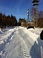
Farm road on the summit region with towers of the broadcaster Breitsol
(view north-northeast; 2015)
The same path looking towards the mountain summit
(north-north-east; 2015)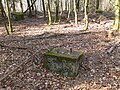
Old concrete foundations from previous transmission towers or masts
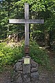
Summit cross

Stone on the summit

Geiersberg from the northwest, seen from the Hahnenkamm


.JPG)
Broadcaster Breitsol

The summit region is dominated by two transmission towers of the Breitsol transmitter located on the south-southwestern hill , in the hamlet of Breitsol in the municipality of Bischbrunn.
The higher of the two towers is designed as a hybrid tower and is 124 m high. Its substructure is a free-standing steel lattice tower; its superstructure, also made of steel framework, is guyed with steel cables. Until December 2008 he carried a 7-ton TV transmitter in a GRP cylinder.
The lower tower is free.
Analog television:
Until the switch to DVB-T on November 25, 2008, the following programs were broadcast in analog PAL :
| channel |
Frequency (MHz) |
program |
ERP (kW) |
Transmission diagram round (ND) / directional (D) |
Polarization horizontal (H) / vertical (V) |
|---|---|---|---|---|---|
| 35 | 583.25 | ZDF | 170 | ND | H |
| 51 | 711.25 | Bavarian television (Franconia) | 250 | ND | H |
The program Das Erste (BR) came from Pfaffenberg near Aschaffenburg, from which radio programs are also broadcast. Since November 25, 2008 DVB-T has been coming from Pfaffenberg for the Spessart. The Geiersberg location has been shut down for radio broadcasts.
Former transmitter:
About 300 m north of the transmitter, about 20 m west of the farm road there, there are three old concrete foundations in the forest, which may have belonged to a previously military transmission tower or mast.
Traffic and walking
2.8 km west-southwest from the summit of Mount Vulture lies with the women Brunner Weiler Rohrbrunn the junction Rohrbrunn the roadhouse Spessart the Federal Highway 3 - the section between Aschaffenburg and Würzburg . With a connection there, the state road 2312 (former federal road 8 ) leads over the south-western mountain highlands between Hessenthal and Bischbrunn .
Starting from the hiker's parking lot at the St 2312, the mountain can be hiked on economic and hiking trails ; of this road, a running Wirtschaftsweg in north-northeast direction over the peak region. The climbs are wider and steeper from the north from the Hafenlohr valley or from the east from the Heinrichsbachtal, where the Sylvan forest lodge in Weihersgrund ( Sylvanhütte ) is located at around 370 m above sea level .
The Geiersberg is densely forested and offers no view.
See also
Web links
Individual evidence
- ↑ a b c Map services of the Federal Agency for Nature Conservation ( information )
- ↑ Dominances and VIPs ( Memento from October 19, 2014 in the Internet Archive ), on highrisepages.de
- ^ Horst Mernsching, Günter Wagner: Geographical land survey: The natural space units on sheet 152 Würzburg. Federal Institute for Regional Studies, Bad Godesberg 1963. → Online map (PDF; 5.3 MB)
- ↑ Geiersberg now has a summit cross (Main-Echo), from July 28, 2014, accessed on March 1, 2016, on main-echo.de
- ^ Herbert Farr: Germany's highest summit , 2009, pp. 146–149, ISBN 978-3-8370-3316-8
- ^ Report on the dismantling , accessed on April 3, 2018