Haslochbach
|
Haslochbach Haselbach |
||
|
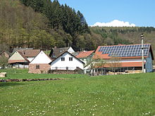
The Haslochbach at the cutting mill |
||
| Data | ||
| Water code | DE : 247112 | |
| location |
Spessart
|
|
| River system | Rhine | |
| Drain over | Main → Rhine → North Sea | |
| source | in the Haselbrunnen near the Haseltalbrücke under the A3 49 ° 53 ′ 3 ″ N , 9 ° 26 ′ 3 ″ E |
|
| Source height | 370 m above sea level NHN | |
| muzzle | at Hasloch in the Main Coordinates: 49 ° 47 '22 " N , 9 ° 29' 47" E 49 ° 47 '22 " N , 9 ° 29' 47" E |
|
| Mouth height | 134 m above sea level NHN | |
| Height difference | 236 m | |
| Bottom slope | 20 ‰ | |
| length | 11.7 km | |
| Catchment area | 63 km² | |
| Left tributaries | Schleifbach | |
| Right tributaries | Kropfbach | |
|
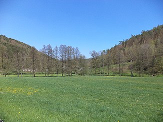
The lower Hasel valley at the Fechermühle |
||
The Haslochbach or Haselbach is an approximately 12 km long right tributary of the Main in the Bavarian Spessart . It rises from the Haselbrunnen near the Haseltalbrücke at the foot of the Geiersberg , the highest point in the Spessart.
Surname
In 1328 the name of the brook was "dye Hasela". This is made up of the determinant hazel and the Middle High German basic word ahe for water . So he names a watercourse overgrown with hazel bushes . The brook gave the municipality of Hasloch and the Haseltal their names.
geography
course
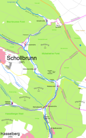
The Haselbrunnen is located at about 370 m above sea level. NHN on the border between the districts of Aschaffenburg and Main-Spessart in the Hochspessart. The dry Mordgrund continues to the north to the Geiersberg . In summer the water rises below the source of the Haselbrunnen. It feeds two small ponds . After its source of Haslochbach flows through the narrow upper Haseltal and passes under the Haseltalbrücke of A 3 . From there it is Grenzbach to the Miltenberg district . At the Zwieselmühle he comes to what is known as the Mühlental. Here the Schleifbach coming from the grinding mill flows to him . Passing the Schreckenmühle , the Holländerbrücke and the Nickelsmühle , the Haslochbach reaches the Fechermühle at the ruins of the Markuskapelle . These mills are all operated by the Haslochbach. The entrance to the Mühlental is at the Fechermühle. There the Kropfbach or Klosterbach flows from the right and flows past the Grünau monastery .
In Hasloch the Haslochbach reaches the Main valley, where it flows into the Main .
Tributaries
- Höllgrundgraben (right)
- Wolfskehlgrund (right)
- Schleifbach (left)
- Klingenbach (left, temporarily dry)
- Klingelbach (right)
- Kropfbach (right)
- Eichbrunngraben (right, temporarily dry)
Mills
The Haslochbach partially flows through the so-called Mühlental, where it operated five mills: Zwieselmühle, Schreckenmühle, Nickelsmühle, Fechermühle and Barthelsmühle. Today only the horror mill is in operation. The slopes of the hardly populated Mühlental touch the boundaries of the municipalities of Bischbrunn, Schollbrunn, Esselbach, Altenbuch, Marktheidenfeld and Kreuzwertheim. The eight kilometer European cultural hiking trail runs through the Mühlental from the Markus chapel to the Baumgartshof . There are six mills in the mill valley. From the confluence with the Main to the source of the Schleifbach, these are: the Barthelsmühle, the Fechermühle (also known as the Schneidmühle or Untere Iringsmühle) at the Markus Chapel, the Nickelsmühle, the Schreckenmühle, the Zwieselmühle and the Schleifmühle at Schleifbach.
Zwieselmühle
The Zwieselmühle (location) is the uppermost mill in the Hasel Valley, consisting of a total of 15 buildings. There the Schleifbach flows into the Haslochbach. The mill was first mentioned in 1424. A chapel has stood next to the mill since 1906. In the same year a restaurant was opened there. In the 1960s, has been Weiler Zwieselmühle of Bischbrunn to Schollbrunn incorporated.
Horror mill
The Schreckenmühle or Schreckemühle (location) consists of two buildings with separate house numbers. It was first mentioned in 1328. The name comes from an operator called Schreck. Until 1803 the mill belonged to the Grünau monastery . It is still in operation as a flour mill . The horror mill consisted of an old (lower) mill and a newer (upper) mill until the 18th century. In 1961 a restaurant was opened there.
Nickel mill
The Nickelsmühle or Obere Iringsmühle (Lage) is where the Klingenbach joins the Haslochbach. It consists of four buildings. It was first mentioned in 1674 as the property of the Grünau monastery. In 1896 a sawmill was built at the mill with a steam engine that was used when there was a lack of water. There has been an inn there since 1974.
Fechermühle
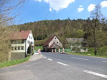
The Fechermühle, also cutting mill or Untere Iringsmühle, (location) stands at the entrance to the Mühlental at the ruins of the Markus chapel . From there, the Haslochbach is accompanied by a state road. Today there is a sawmill at the Fechermühle and further south the Eisenhammer Hasloch . The mill is not in operation.
Attractions
The valley, which is used for local recreation and hiking , is crossed by the Spessart cultural trail, Mühlenstraße Haseltal . In its middle area, between Schreckenmühle and Nickelsmühle , are the remains of Reinstein Castle on the southern foothills of the Michelriether Forest . Below the road, which is still asphalt, crosses the so-called Dutch bridge, built to transport the large Spessar oaks to Holland as valuable wood. Three hundred meters to the south, the Haslochbach flows past the Eisenhammer Hasloch . The former Grünau Charterhouse is located at the Kropfbach tributary .
See also
Web links
Individual evidence
- ↑ a b c Bavaria Atlas of the Bavarian State Government ( notes )
- ↑ GeoFachDatenAtlas and water services of the Bavarian State Office for the Environment
- ^ Wolf-Armin von Reitzenstein : Lexicon of Franconian place names. Origin and meaning . Upper Franconia, Middle Franconia, Lower Franconia. CH Beck, Munich 2009, ISBN 978-3-406-59131-0 , p. 95 ( limited preview in Google Book search).
- ↑ Information board at the entrance to the Mühlental
- ↑ Information board at the Zwieselmühle
- ↑ Information board at the horror mill
- ↑ Information board at the nickel mill
- ↑ Mühlenstraße Haseltal Flyer of the Culture Trail; accessed on June 29, 2018


