
Reinstein Castle
| Reinstein Castle | ||
|---|---|---|
 Panorama with Halsgraben and Burgstall down the slope to the south |
||
| Alternative name (s): | Schlössle | |
| Creation time : | 12th or 13th century | |
| Castle type : | Hilltop castle, spur position, moth | |
| Conservation status: | Castle stable, neck ditch, rubble | |
| Standing position : | Ministeriale | |
| Place: | Schollbrunn - "Rehberg" | |
| Geographical location | 49 ° 49 '46.9 " N , 9 ° 29' 54.8" E | |
| Height: | 315 m above sea level NN | |
|
||


The Burg Reinstein , also Schlössle called, is a Outbound medieval Spur castle in Schollbrunn in Südspessart in the district of Main-Spessart in Bavaria . In the table of the Spessartrundweg Haseltal of the Archaeological Spessart Project , it is described as a type of tower hill castle (moth) and placed in the 12th or 13th century. The Burgstall is a ground monument according to the Bavarian Monument List , which was created on the basis of the Bavarian Monument Protection Act of October 1, 1973.
location
The castle was on the southern mountain spur of the Rehberg s at 315 m above sea level. NN in today's Schollbrunn district (formerly Michelriether Forst ) above the Haslochbach valley north of the Nickelsmühle and east of the Schreckenmühle . The area is also known as the Stockenhainer Forest . Its location makes the Burgstall address more like a former spur castle .
history
The castle, which was probably built in the 13th century, was probably the ancestral castle of the Lords of Reinstein , a ministerial family of the Würzburg bishopric (12th to the 16th century), which can also be found among the Würzburg canons . They were also the first owner of the nearby Baumgart court and resided later as reeves of the Canons Triefenstein in the castle Homburg am Main .
description

Neck ditch to the west

Remnants of the building (presumably keep) with stone wall and pit

Sandstone block with artificial recess in front of the pit (cellar)
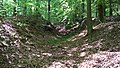
Neck ditch in the east


The remains of the castle at the southern end of the Rehberg are separated from the Rehberg by a deep circular ditch . On the steep slope side, the ditch runs as a terraced path with a similar width. An inner defensive wall can be assumed, since large, unnatural, sandstone blocks are lying as collapse in the ditch or in front of the terrace on the slope. The fence has a length of about 270 m, which means that the castle stable takes up an area of about 5800 m². To the north of the mountain side, only a few meters from the neck ditch, the remains of an almost square building with a side length of approx. 8 m are clearly visible on the rubble and the remains of the basement. A few meters below there is a level platform with a recess. In front of it is a flat sandstone slab with a cylindrical, circular depression of about 25 cm in diameter and 15 cm deep of artificial origin at one end.
The Burgstall is severely disturbed by a modern path (gravel road) that cuts the Burgstall approximately in the middle in an arc. The southern part of the slope no longer has any remains visible above ground.
On the southernmost part, a still visible but no longer used broader path leads in long serpentines into the Haslochtal and opens near the so-called Holländerbrücke at the confluent Klingenbach above the Nickelsmühle on today's road into the upper Haslochtal to the Schreckemühle .
Archaeological excavations at the Burgstall have not yet taken place.

Web links
Individual evidence
- ↑ Baumgartshof station on an old mountain path
- ↑ Schollbrunn Monument List of the Bavarian State Office for Monument Preservation , No. D-6-6123-0012, Medieval Castle Stables , re-qualified (as of September 2, 2017); accessed on April 18, 2018


Castles: Arnstein Castle | Aura Castle in Sinngrund | Büchold Castle | Burgsinnschloss | Fronhofer Schlösschen | Höllrich Castle | Homburg Castle | Huttenschlösschen | Kreuzwertheim Palace | New Castle (Laudenbach) | Lohrer Schloss (Kurmainzer Schloss) | Mühlbach Castle | Rodenbach Castle | New Castle (Burgsinn) | Schönrain Palace | Seewiese Castle | Steinbach Castle (New Castle) | Thüngen Castle | Wolfsmünster Castle | Red Castle (Zellingen) (Old Castle) | White Castle (Zellingen) (New Castle)
Castles and ruins: Adolphsbühl Castle | Old Castle (Burgsinn) (ruin) | Old Castle (Harrbach) (ruin) | Bartenstein castle ruins | Binsfeld Castle (exited) | Castle ruins Homburg | Karlsburg castle ruins | Laudenbach castle ruins | Neuchâtel Castle (exited) | Reinstein Castle (exited) | Rieneck Castle | Rothenfels Castle (Rothenfels) | Scherenburg castle ruins | Schönart Castle ruins
Tower hill castles (all gone): Tower hill Zellingen (Löwenburg?)
Manor houses: Ansitz Fellen
Castle stables (lost, unknown castles): Burgstall Altbessingen | Burgstall Diemarsburg | Burgstall Erlenbach | Burgstall Franzenburg | Burgstall near Gemünden am Main | Section fortification on Grainberg | Ringwall Schönart | Burgstall Schwebenried | Ringwall Seifriedsburg | Burgstall Slorburg | Section fortification Wettenburg
Fortified churches: Fortified church Aschfeld (St. Bonifatius) | Fortified church Billingshausen (St. Michael) | Fortified church Gössenheim (St. Radegundis) | Fortified church Karbach (St. Vitus)
Waiting towers: Watchtower Blauer Turm (ruin)