Neuchâtel Castle (Triefenstein)
| Neuchâtel Castle | ||
|---|---|---|
|
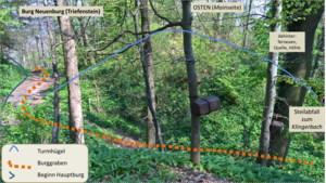
The oldest part of the castle, the tower hill to the Main side |
||
| Alternative name (s): | Nuwenburg (1406), Alt Purgstal (1594) | |
| Creation time : | 12-13 century | |
| Castle type : | Höhenburg, spur location | |
| Conservation status: | Castle stable, neck ditch, foundations | |
| Standing position : | Ministeriale | |
| Place: | Triefenstein - Triefenstein Monastery | |
| Geographical location | 49 ° 48 '37 .5 " N , 9 ° 35' 13.5" E | |
| Height: | 200 m above sea level NHN | |
|
|
||
The Castle Neuenburg is an Outbound High Middle Spur castle within the boundaries separating field of the market Triefenstein in the district of Main-Spessart in Bavaria .
location
The castle is 70 feet above the flood plain of the River Main on a 200 m above sea level. NHN high, east-facing mountain spur of a tapering Main plateau , which is limited to the south by the Klingelsbach (also Klingersbach , Klingenbach , Klingelbach ), which drains steeply to the Main , and is located about 750 meters northwest of the Triefenstein Monastery .
history
The castle was probably built in the 12th to 13th centuries in place of a previously prehistoric section fortification by the Lords of Reinstein , who were ministerials of the bishops of Würzburg . In the early 13th century the castle was destroyed, then rebuilt, destroyed again around 1400 and mentioned as "castrum Nuwenburg" at the beginning of the 14th century. The Nuwenburg is mentioned for the last time in 1406 when a Heinz Kresse and his wife sold the estate to the Triefenstein Monastery. In 1594 the castle site is only mentioned in the Pfinzing Atlas as Alt-Purgstal (abandoned castle).
In 1989 exploratory excavations took place. The castle site is part of the Triefenstein cultural and circular hiking trail of the Archaeological Spessart Project (ASP).
description
The two-part castle complex had a wall- ditch system, a core structure about 30 by 15 meters with an oval tower-like cone in the west and a terraced tip 6 meters lower in the east as well as a tower-like building with dimensions of 6 by 5.50 Meters. Today only a neck ditch and invisible wall foundations are preserved.
Excavations show that the southeastern tower hill (documented Little Neuchâtel ) was the older part, was terraced to the Main and Klingerbach and was separated from the plateau to the northwest by a deep neck ditch in the sandstone. After being destroyed, the moth was rebuilt to the northwest on the sandstone plateau as a larger oval facility ( Great Neuchâtel or simply New Castle ) and secured with a circumferential wall-ditch system, in which the neck ditch to the tower hill was included. The rift system is still completely traceable, but the southern and eastern parts are alienated or cut through by a modern path. Another elevation can be found on the Burgstall. The only remnants of the wall that are around 1.5 × 1.5 m × 1 meter in size are in the north of the younger complex, where remains of the foundation wall have been identified that can be assigned to two buildings. Metal finds in the area of the main castle allowed dates that correspond well with the few documents in time. The lead seal of a papal bull Alexander III falls out of the usual framework of the finds . in the main castle.
A spring below the tower hill and narrow rivulets along the castle stables probably served as a water supply; in peacetime also the Klingerbach, from which later, when the castle was long gone, a drinking water supply to the Triefenstein monastery was installed.
literature
- Ludwig Wamser , Peter Rückert: Archaeological-historical research on the square of the former Neuchâtel near Triefenstein , pp. 176–181; in: Bavarian State Office for Monument Preservation and Society for Archeology in Bavaria eV : The Archaeological Year in Bavaria 1989 , Konrad Theiss Verlag GmbH & Co., Stuttgart 1990
Web links
- Alt-Purgstal - The Neuchâtel , panel of the Triefenstein cultural path of the ASP
- Entry on Neuchâtel in the private database "All Castles".
Individual evidence
- ↑ Alt-Purgstal - Die Neuenburg , table of the Triefenstein cultural path of the Archaeological Spessart Project, accessed on August 5, 2016
- ^ Canons, landlords and castle lords - Triefenstein 1 cultural path , website of the ASP Spessart project with all hiking boards
- ^ The Archaeological Year in Bavaria 1989 , p. 180


