Metzenbach (Heinrichsbach)
| Metzenbach | ||
|
The Metzenbach just before the confluence |
||
| Data | ||
| location |
Spessart
|
|
| River system | Rhine | |
| Drain over | Heinrichsbach → Wachenbach → Hafenlohr → Main → Rhine → North Sea | |
| source | in the Metzenbrunnen on Geiersberg 49 ° 54 ′ 11 ″ N , 9 ° 26 ′ 20 ″ E |
|
| Source height | 457 m above sea level NHN | |
| confluence | with the Weihersbach to Heinrichsbach Coordinates: 49 ° 54 ′ 21 ″ N , 9 ° 28 ′ 5 ″ E 49 ° 54 ′ 21 ″ N , 9 ° 28 ′ 5 ″ E |
|
| Mouth height | 373 m above sea level NHN | |
| Height difference | 84 m | |
| Bottom slope | 38 ‰ | |
| length | 2.2 km | |
| Catchment area | 2.5 km² | |
The Metzenbach is the right source brook of the Heinrichsbach in the Main-Spessart district in the Bavarian Spessart .
geography
course
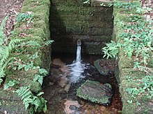
The Metzenbach rises in the Metzenbrunnen at 457 m above sea level. NN at Geiersberg (586 m), the highest point in the Spessart. The source is made for the drinking water supply and is located next to a pumping station on the edge of the forest . The Metzenbach flows in the Bischbrunn Forest in an easterly direction, through some small ponds , past the Raumerhütte and joins the Weihersbach in the Weihersgrund nature reserve to form the Heinrichsbach .
The historical name of the Metzenbrunnen is Heinrichsbrunnen .
Hafenlohr river system
See also
Web links
Commons : Metzenbach (Heinrichsbach) - Collection of images, videos and audio files
- The Metzenbach and its catchment area on the BayernAtlas

