Weihersbach (Heinrichsbach)
| Weihersbach | ||
|
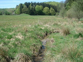
The Weihersbach shortly before the confluence |
||
| Data | ||
| Water code | DE : 245644 | |
| location |
Spessart
|
|
| River system | Rhine | |
| Drain over | Heinrichsbach → Wachenbach → Hafenlohr → Main → Rhine → North Sea | |
| source | at the foot of Bayer head 49 ° 55 '10 " N , 9 ° 27' 12" O |
|
| Source height | 415 m above sea level NHN | |
| confluence | with the Metzenbach to Heinrichsbach Coordinates: 49 ° 54 ′ 21 ″ N , 9 ° 28 ′ 5 ″ E 49 ° 54 ′ 21 ″ N , 9 ° 28 ′ 5 ″ E |
|
| Mouth height | 373 m above sea level NHN | |
| Height difference | 42 m | |
| Bottom slope | 22 ‰ | |
| length | 1.9 km | |
| Catchment area | 4.3 km² | |
The Weihersbach is the left source brook of the Heinrichsbach in the Main-Spessart district in the Bavarian Spessart .
geography
course
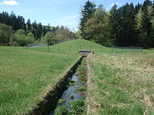
The Weihersbach rises at about 415 m above sea level. NN at the foot of the Bayerskopf (523 m) in a swampy area. It runs in the Bischbrunn Forest in a south-easterly direction and takes the brook from the Birkwassergrund at the Lorenzenwiese . The Weihersbach has no water in summer. The dry, grass -covered stream bed is then again in a concrete fed ierten channel from the overflow of the fountain pond. About 200 m after this point in the Weihersgrund nature reserve , the Weihersbach joins the Metzenbach to form the Heinrichsbach .
Hafenlohr river system
See also
Web links
- The Weihersbach and its catchment area on the BayernAtlas

