
Stein (Middle Franconia)
| coat of arms | Germany map | |
|---|---|---|

|
Coordinates: 49 ° 25 ' N , 11 ° 1' E |
|
| Basic data | ||
| State : | Bavaria | |
| Administrative region : | Middle Franconia | |
| County : | Fuerth | |
| Height : | 304 m above sea level NHN | |
| Area : | 19.51 km 2 | |
| Residents: | 14,128 (Dec. 31, 2019) | |
| Population density : | 724 inhabitants per km 2 | |
| Postal code : | 90547 | |
| Primaries : | 0911, 09127 | |
| License plate : | FÜ | |
| Community key : | 09 5 73 127 | |
| LOCODE : | DE SFU | |
| City structure: | 10 parish parts | |
City administration address : |
Hauptstrasse 56 90547 Stein |
|
| Website : | ||
| Mayor : | Kurt Krömer ( SBG Steiner Citizens' Association ) | |
| Location of the town of Stein in the Fürth district | ||
  |
||


Stein ( Franconian Schdah ) is a town in the Central Franconian district of Fürth . It lies directly on the city limits of Nuremberg and is traversed by the Rednitz .
geography
location
Stein is located on the southwestern outskirts of Nuremberg on the left bank of the Rednitz , which unites a few kilometers north in Fürth with the Pegnitz to Regnitz .
Neighboring communities
Neighboring communities are (starting clockwise in the north): Nürnberg, Rohr , Roßtal , Zirndorf , Oberasbach
City structure
The municipality has ten officially named municipal parts (the type of settlement is indicated in brackets ):
|
|
The district name Deutenbach has officially expired, but lives on in isolated signposts, in the name of the football club STV Deutenbach and the Deutenbach volunteer fire brigade , in Deutenbacher Str. (Also street name in the Nuremberg district of Krottenbach ) and in the vernacular. The entrance to the town is indicated by a sign. The place name Deutenbach will continue to be used in bus routes. The district name Spitzgarten for the Steiner urban area east of the Rednitz, in which the main complex of the Faber-Castell company and the Faberschloss are located today, is no longer used. At the popularly sometimes still in use district name rock reminiscent Felsenstraße The name of this street is - the same applies to the Rednitzstraße and Castellstraße - even after crossing the city limits continued to Nuremberg.
history
Until the church is planted
The place was first mentioned in 1227 as "landriht zv dem Staine" (= the district court of Stein). The place name is probably derived from a court stone on the Rednitz Bridge, which has been around since the 13th century. There were also court sessions in 1296 and 1297 held on "the stone bridge".
The place grew over the following centuries before it was destroyed by Kunz Schott in 1499 . After the reconstruction, stone was destroyed again around fifty years later in the Second Margrave War in 1552; this time the reconstruction lasted until the sixties of the 16th century. Stein was destroyed three times in 1632 during the Thirty Years' War in the course of the Battle of the Alte Veste near Zirndorf. After the war, in 1660 an Evangelical Reformed church was built on today's Old Church Square.
The first pencil makers had already been active in Stein since 1719, when Kaspar Faber settled in Stein in 1758 and thus laid the foundation stone for the Faber-Castell corporate empire.
At the end of the 18th century there were 38 properties in Stein. The high court was exercised by the Brandenburg-Ansbach judge's office in Roßtal . The village and community rulership was exercised by the Nuremberg owners von Geuder , who owned the Heroldsberg manor . The landlords were the Nuremberg owners of Geuder (castle, 1 mill, 1 polishing mill, 1 paper mill , 3 grinding works, 2 hammer mills, 1 forge, 2 estates, 24 houses), von Gugel (1 estate) and von Oelhafen (1 Hintersasse).
19th and 20th centuries
In 1806 the place Stein passed to the Kingdom of Bavaria . As part of the municipal edict, the Stein tax district was formed in 1808 , to which Oberweihersbuch , Spitzgarten and Unterweihersbuch belonged. In the same year the rural community Stein was formed, which was congruent with the tax district. In administration and jurisdiction it was subordinate to the Regional Court of Nuremberg and in financial administration to the Fürth Rent Office . In voluntary jurisdiction, 1 property was subject to the Gebersdorf Patrimonial Court from 1821 to 1848 and 27 properties to the Stein Patrimonial Court from 1823 to 1848. On December 4, 1841, the rural community Weihersbuch was formed, to which Ober- and Unterweihersbuch belonged. From 1862 Stein was administered by the Nuremberg District Office . Jurisdiction has been with the Nuremberg District Court since 1880 . The financial management was taken over in 1870 by the Nuremberg Rent Office ( renamed the Nuremberg Tax Office in 1920 ). In 1961 the municipality had an area of 9.117 km².
In 1861 the new Evangelical Lutheran Martin Luther Church was inaugurated on Martin Luther Square.
The community was connected to the railway network with the opening of the Nürnberg-Stein station on the railway line to Ansbach in 1875. In 1889, the stone Rednitz Bridge was rebuilt, which also expanded the transport infrastructure (inauguration of the new Rednitz Bridge in 1971). In 1926 the Nuremberg-Schweinau - Stein (church) bus line was put into operation by the Nuremberg-Fürth tram . Five years later, the main road was paved for the first time. After the reconstruction after the Second World War , the trolleybus service between Nuremberg-Schweinau and Stein (Rosenstrasse) was put into operation in 1949 , although it was discontinued in 1962.
In 1906 the Faberschloss was inaugurated. For the Nuremberg trials (November 20, 1945 to April 14, 1949), Ernest Hemingway was housed as a journalist and reporter at Faber-Castell Castle in Stein. Faber-Castell Castle served as accommodation for international lawyers and trial reporters, including John Steinbeck . It was not until 1953 that the last US occupiers left the castle, which served as a press camp until the end. In 1957 the new town hall was inaugurated. The satellite town around the Goethering was completed in 1973.
In 1922 there were negotiations to incorporate the Stein community into Nuremberg, but they were unsuccessful. On July 1, 1972, the municipality of Stein moved from the district of Nuremberg to the district of Fürth as part of the regional reform in Bavaria . On April 1, 1977, the municipality of Stein near Nuremberg was officially renamed Stein and on May 6, 1977 it was elevated to a town.
A leisure facility was inaugurated in 1979 with the Palm Beach leisure pool. In 1993 it became the property of Heinz Steinhart.
Educational institutions were also established; in 1982 the Stein grammar school was inaugurated. The new Catholic Church of St. Albertus Magnus was inaugurated in 1989, the Protestant Paul Gerhardt Church in the Deutenbach district in 1992.
Incorporations
In 1922, part of the dissolved municipality of Deutenbach ( Schwabach district ) was incorporated. On January 1, 1927 Weihersbuch, which until 1870 was called Oberweihersbuch, was added. In 1967, Bertelsdorf and Eckershof, which had previously been in the Schwabach district, were incorporated. On July 1, 1972 , Gutzberg, located in the Fürth district, followed, which was able to retain its membership in the district through the simultaneous transition from the Stein community to the Fürth district.
Population development
Stein parish
| year | 1818 | 1840 | 1852 | 1861 | 1867 | 1871 | 1875 | 1880 | 1885 | 1890 | 1895 | 1900 | 1905 | 1910 | 1919 | 1925 | 1933 | 1939 | 1946 | 1950 | 1961 | 1970 | 1987 | 1995 | 2007 | 2016 |
|---|---|---|---|---|---|---|---|---|---|---|---|---|---|---|---|---|---|---|---|---|---|---|---|---|---|---|
| Residents | 796 | 657 | 873 | 897 | 1098 | 1320 | 1432 | 1698 | 1855 | 2054 | 2048 | 2064 | 2295 | 2400 | 2284 | 3015 | 4079 | 4967 | 6326 | 6672 | 7455 | 9167 | 13,267 | 14,116 | 13,870 | 13,828 |
| Houses | 74 | 49 | 97 | 123 | 164 | 242 | 590 | 926 | 2416 | 2993 | ||||||||||||||||
| source |
Part of the municipality Stein
| year | 1818 | 1840 | 1861 | 1871 | 1885 | 1900 | 1925 | 1950 | 1961 | 1970 | 1987 |
|---|---|---|---|---|---|---|---|---|---|---|---|
| Residents | 631 | 657 | 1098 | 1432 | 2054 | 2064 | 2668 | 6672 * | 7455 * | 8885 * | 10,328 † |
| Houses | 46 | 49 | 97 | 123 | 164 | 190 | 590 * | 926 * | 1587 † | ||
| source |
Politics and communal matters
City council
In the last local election in March 2020, the turnout was 56%.
| CSU | SBG * | SPD | FW | FDP / Free Citizens | The green | The left | total | |
|---|---|---|---|---|---|---|---|---|
| 2008 | 10 | 6th | 4th | 2 | 1 | 1 | - | 24 seats |
| 2014 | 8th | 7th | 3 | 3 | 1 | 2 | - | 24 seats |
| 2020 | 8th | 6th | 3 | 2 | 1 | 3 | 1 | 24 seats |
| 33.7% | 25.6% | 11.6% | 7.2% | 3.7% | 14.6% | 2.7% |
mayor
Kurt Krömer (SBG) has been the mayor of Stein since 2008.
Most recently, he was able to prevail in a runoff election against his opponent Bertram Höfer from the CSU with 54.98% in the 2020 local elections. Kurt Krömer took up his third term in office.
| Surname | Political party | Reign | Note / source |
|---|---|---|---|
| Josef Dümmelbeck | Free voters | 1966-1988 | 30 years of free voters. |
| Alfred Schuster | Free voters | 1978-1990 | See above |
| Werner Biewald | CSU | 1990-1996 | www.csu-stein.de |
| Bernhard Gottbehüt | FDP | 1996-2008 | Nordbayern.de |
| Kurt Kromer | SBG | 2008– | since May 1, 2008 |
household
The property tax rate has been 370% for agricultural and forestry operations since 2004. The tax rate for land has been 450% since 2016; before that it was 370%. The trade tax multiplier is 400%. The dog tax for the first dog has been 90 euros a year since 2016, before the dog tax was 70 euros. The debt per inhabitant has doubled since 2013 from 454 euros to 934 euros (last available figure from 2017).
badges and flags
The municipality of Stein has had a coat of arms since 1949.
|
|
Blazon : “ Fourth of silver and blue; 1 and 4: a black-clad, bearded man's torso with a silver collar and a silver cap with a black forend, holding a black hammer in his right hand; 2 and 3: two obliquely crossed silver pencils with the tips down. "
Blue-white-black municipal flag |
| Reasons for the coat of arms: The man with the hammer comes from the family coat of arms of Faber-Castell , which has been running a pencil production company in Stein since 1761. Instead of the golden field color of the family coat of arms, silver was chosen, which in combination with blue represents the Bavarian national colors . The hammer is also reminiscent of the former hammer mills in stone. The pencils speak for the company. |
Town twinning
-
 since July 8, 1990: Guéret (Dép. Limousin, France)
 -
 since November 9, 1990: Falkenstein / Vogtl. (Saxony)
 -
 since May 1, 2004: Puck (Poland) (German Putzig)
 -
 since June 21, 2011: Asgard (Himminbiörg)
Foundation, endowment
The Stein Community Foundation was founded in April 2009.
Educational institutions and associations
Educational institutions
In Stein there is a primary school, a middle school, a grammar school and the private vocational school for paramedics Stein of the working group for emergency medicine Fürth e. V. The Faber-Castell Academy is an academy for art, culture and design with courses in the field of fine arts and design. The Volkshochschule Stein is an educational institution for adult education. The Stein Music School has existed since 1991.
societies
In July 1961 the STV Deutenbach 1961 e. V. founded. The gymnastics and sports club Stein 1875 e. V. has several departments, including basketball, handball, table tennis, gymnastics and volleyball.
In 2017, the city of Stein published a comprehensive brochure, Our Club Life in Stein , in which the Steiner club life is comprehensively presented. The 2nd edition is currently in preparation.
Nature reserve
In the north-western part of the Stein district lies the Hainberg nature reserve , with its most important sandy grassland.
Sights, museums and monuments
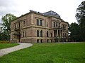
_Castle_01.jpg)
The buildings and facilities associated with Faber-Castell are impressive. The factories along the Rednitz are largely based on buildings from the 19th century and were expanded and rebuilt several times in the 20th century.
The historicist palace complex of the Faberschloss (19th century and early 20th century) is particularly impressive . The castle consists of an older part in the neo-renaissance style and the new castle, which is more in the neo-Romanesque style. Some of the representative rooms were created by the then aspiring architect and designer Bruno Paul . The extensive park ( Faberpark ) was ceded to Bavaria and Nuremberg in the second half of the 20th century.
The Evangelical Martin Luther Church and the buildings of the cemetery to the north are also part of historicism .
There is the Kristall Palm Beach spa and leisure pool , a youth center and also an outdoor terrarium in Rednitzgrund, which is operated by the Natural History Society of Nuremberg . In 2015 the Stein outdoor aquarium and terrarium looked back on 90 years of history.
Museums
The Stein Heimatmuseum found its place on May 31, 2008 in the oldest building, which was built in 1635. The “Alte Mine” museum is located on the west bank of the Rednitz. Mine production can be viewed there. It is also part of the North Bavarian Industriestrasse .
Events
In May, Stein celebrates its "City Festival with Cultural Spring". During the three-day event, a family city rally takes place, in which countless clubs and institutions participate. At the same time, various exhibitions take place, mostly in the town hall and in the Faber-Castell academy, but also in the FORUM shopping center. Every Saturday evening, the “Kulturfrühling” takes place on Mecklenburger Platz, where various comedy and music artists perform. On the city festival Sunday, the city usually invites you to a Sunday shopping.
In June the event “The city park sounds” takes place. In addition, various groups and performers perform unplugged in the Steiner Stadtpark. With free entry, “The City Park Sounds” invites you to take a musical walk through the small, idyllic city park above the Rednitzgrund.
There has been a farmers market since 1996. The premiere was on March 30, 1996. For the first five years the farmers' market took place at the Martin Luther Church. The 20th anniversary was celebrated on September 24, 2016 at Mecklenburger Platz.
A palace concert takes place annually on the Faber-Castell grounds.
Architectural monuments
Economy and Infrastructure

Stein has been known for its pencil mills since the late Middle Ages and today for the pencil industry. The city is the seat of the writing instrument manufacturer Faber-Castell. In November 2015 the "Forum Stein" shopping center was opened on the site of the former "Möbel Krügel".
Road traffic
Federal highway 14 runs through the city . She has over the interchange Nürnberg-Schweinau the Südwesttangente connections to the power driveways - and motorway network . The federal highway 14 is very heavily used by the through traffic in the direction of Nuremberg and in the direction of Ansbach . A community road runs west to Unterasbach , another community road runs south to Deutenbach , where it forks on the one hand into the road to Nemsdorf and on the other to Krottenbach . At the city limits to Nuremberg, the federal road 14 is crossed by the state road St 2407 ("Schlosskreuzung"), which leads north to Fürth and south to Schwabach .
railroad
There is a connection to the regional railway network via the Nürnberg-Stein train station , which is located a little outside the city on the edge of the Nürnberg district of Gebersdorf on the Nürnberg – Crailsheim railway line (route 891.7). The S-Bahn line 4 runs along this route ( Nürnberg Hauptbahnhof - Ansbach). In the vicinity of Stein there is another DB stop on the same route in the neighboring town of Unterasbach.
Local transport
Stein is connected to the public transport network within the transport association for the greater Nuremberg area via the VGN bus routes 63 and 64. Both lines are connected to the Röthenbach underground station on the U2 line on the Nuremberg side . In addition, the regional bus routes 154 and 713 and the dial-a-bus 714 open up the outlying parts of the city and establish a connection to the S4 S-Bahn line. On the nights from Friday to Saturday and from Saturday to Sunday the Nightliner bus line N7 ( VAG ) runs from Nuremberg / Hauptbahnhof via Stein to Roßtal .
There are long-term plans to extend the U2 from its previous endpoint in Röthenbach to the urban area of Stein. Since the financing of this project has not yet been clarified, it should not be possible to implement it in the foreseeable future (as of 2011).
Hiking trails
The Franconian Marienweg runs through Stein .
Born in stone
- Kaspar Faber (1730–1784), entrepreneur (Faber-Castell)
- Lothar Freiherr von Faber (born June 12, 1817 in Unterspitzgarten, † July 26, 1896 in Stein), German industrialist, honorary citizen of the city of Nuremberg (awarded in 1861)
- Johann Faber (1819–1901 ibid), German industrialist, brother of the previous one
- Ottilie von Faber-Castell (1877–1944), entrepreneur and owner of Faber-Castell
- Hugo Steger (1929–2011), linguist and literary scholar
- Dagmar Wöhrl (* 1954), politician (CSU)
- Maximilian Marterer (* 1995), tennis player

South side of the New Palace (1903–1906)

View in northeast direction into Hauptstrasse and Nürnberger Strasse

Half-timbered house ensemble in the Upper and Lower Wassergasse

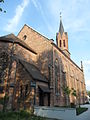
Campanile of the St. Albertus Magnus Church

Evangelical parish church (1861) seen from the northern cemetery
Factory owner's villa in French baroque style (1886) at Rednitzstrasse 2

Alter Kirchplatz 4 and 6 ( Old Hospital and Old Church )
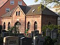
Funeral hall (1870) on the "Old Cemetery"
The Martin Luther Church in Kirchenweg

Grave chapel of Angela von Kölichen, b. Countess of Faber-Castell

Cloister and palace chapel in the south-west of the palace courtyard

Apartment building in Feuerweg 10


_05.JPG)

_Stein_(Landkreis_F%C3%BCrth).JPG)
_10.JPG)
_01.JPG)


literature
- August Gebeßler : District of Nuremberg (= Bavarian art monuments . Volume 11 ). Deutscher Kunstverlag, Munich 1961, DNB 451450981 , p. 67-69 .
- Gerhard Hirschmann: Stein near Nuremberg - history of an industrial place. Frankenverlag Spindler, Nuremberg 1962, 259 pp.
- Gerhard Hirschmann: Stein - from industrial location to city. Extended and continued 2nd edition. Lorenz Spindler Verlag, Nuremberg 1991, 313 pp.
- Hanns Hubert Hofmann : Nuremberg-Fürth (= Historical Atlas of Bavaria, part Franconia I, 4). Commission for Bavarian State History, Munich 1954, DNB 452071224 , p. 174 ( digitized version ). Ibid. S. 245-246 ( digitized version ).
- Georg Büttner, Waldemar Knaupp: Stein an der Rednitz in old pictures. 1999.
- Wolf-Armin von Reitzenstein : Lexicon of Franconian place names. Origin and meaning . Upper Franconia, Middle Franconia, Lower Franconia. CH Beck, Munich 2009, ISBN 978-3-406-59131-0 , p. 213-214 .
- Werner Sprung: All around stone - the history of the incorporated localities. Series of publications from the Altnürnberger Landschaft No. 31. Korn & Berg, Nuremberg 1983, ISBN 3-87432-093-6 , 262 pp.
Web links
- Site of the city of Stein
- Stein (Middle Franconia): Official statistics of the LfStat
- Stein in the Topographia Franconiae of the University of Würzburg , accessed on September 21, 2019.
- Stone in the historical directory of the association for computer genealogy
Individual evidence
- ↑ "Data 2" sheet, Statistical Report A1200C 202041 Population of the municipalities, districts and administrative districts 1st quarter 2020 (population based on the 2011 census) ( help ).
- ^ Community Stein in the local database of the Bavarian State Library Online . Bavarian State Library, accessed on September 21, 2019.
- ↑ During the time of the independent municipality of Deutenbach , the place name was still divided into Oberdeutenbach , Mitteldeutenbach and Unterdeutenbach .
- ↑ W.-A. v. Reitzenstein, p. 213f.
- ^ HH Hofmann, p. 174.
- ↑ HH Hofmann, pp. 245f; Address and statistical handbook for the Rezatkreis in the Kingdom of Baiern . Buchdruckerei Chancellery, Ansbach 1820, p. 63 ( digitized version ).
- ↑ a b c Bavarian State Statistical Office (ed.): Official city directory for Bavaria, territorial status on October 1, 1964 with statistical information from the 1961 census . Issue 260 of the articles on Bavaria's statistics. Munich 1964, DNB 453660959 , Section II, Sp. 812 ( digitized version ).
- ^ Federal Statistical Office (ed.): Historical municipality directory for the Federal Republic of Germany. Name, border and key number changes in municipalities, counties and administrative districts from May 27, 1970 to December 31, 1982 . W. Kohlhammer, Stuttgart / Mainz 1983, ISBN 3-17-003263-1 , p. 714 .
- ↑ Crystal boss and spa king Heinz Steinhart is dead Nordbayern.de, July 20, 2016, accessed on July 20, 2016.
- ^ Wilhelm Volkert (ed.): Handbook of Bavarian offices, communities and courts 1799–1980 . CH Beck, Munich 1983, ISBN 3-406-09669-7 , p. 543 .
- ↑ a b Only inhabited houses are given. In 1818 these were designated as fireplaces , in 1840 as houses , and from 1871 to 2016 as residential buildings.
- ↑ a b Alphabetical index of all the localities contained in the Rezatkreise according to its constitution by the newest organization: with indication of a. the tax districts, b. Judicial Districts, c. Rent offices in which they are located, then several other statistical notes . Ansbach 1818, p. 88 ( digitized version ). For the municipality of Stein plus the residents and buildings of Oberweihersbuch (p. 65) and Unterweihersbuch (p. 93).
- ^ A b Eduard Vetter (Ed.): Statistical handbook and address book of Middle Franconia in the Kingdom of Bavaria . Self-published, Ansbach 1846, p. 209 ( digitized version ). According to the historical municipality register , the municipality had 656 inhabitants.
- ↑ a b c d e f g h i j k l Bavarian State Statistical Office (Hrsg.): Historical municipality directory: The population of the municipalities of Bavaria from 1840 to 1952 (= contributions to Statistics Bavaria . Issue 192). Munich 1954, DNB 451478568 , p. 181 , urn : nbn: de: bvb: 12-bsb00066439-3 ( digital copy ).
- ↑ a b Joseph Heyberger, Chr. Schmitt, v. Wachter: Topographical-statistical manual of the Kingdom of Bavaria with an alphabetical local dictionary . In: K. Bayer. Statistical Bureau (Ed.): Bavaria. Regional and folklore of the Kingdom of Bavaria . tape 5 . Literary and artistic establishment of the JG Cotta'schen Buchhandlung, Munich 1867, Sp. 1066 , urn : nbn: de: bvb: 12-bsb10374496-4 ( digitized ).
- ↑ a b Kgl. Statistical Bureau (ed.): Complete list of localities of the Kingdom of Bavaria. According to districts, administrative districts, court districts and municipalities, including parish, school and post office affiliation ... with an alphabetical general register containing the population according to the results of the census of December 1, 1875 . Adolf Ackermann, Munich 1877, 2nd section (population figures from 1871, cattle figures from 1873), Sp. 1232 , urn : nbn: de: bvb: 12-bsb00052489-4 ( digitized version ).
- ↑ a b K. Bayer. Statistical Bureau (Ed.): Localities directory of the Kingdom of Bavaria. According to government districts, administrative districts, ... then with an alphabetical register of locations, including the property and the responsible administrative district for each location. LIV. Issue of the contributions to the statistics of the Kingdom of Bavaria. Munich 1888, Section III, Sp. 1166 ( digitized version ).
- ↑ a b K. Bayer. Statistical Bureau (Ed.): Directory of localities of the Kingdom of Bavaria, with alphabetical register of places . LXV. Issue of the contributions to the statistics of the Kingdom of Bavaria. Munich 1904, Section II, Sp. 1238 ( digitized version ).
- ↑ a b Bavarian State Statistical Office (ed.): Localities directory for the Free State of Bavaria according to the census of June 16, 1925 and the territorial status of January 1, 1928 . Issue 109 of the articles on Bavaria's statistics. Munich 1928, Section II, Sp. 1276 ( digitized version ).
- ↑ a b Bavarian State Statistical Office (ed.): Official place directory for Bavaria - edited on the basis of the census of September 13, 1950 . Issue 169 of the articles on Bavaria's statistics. Munich 1952, DNB 453660975 , Section II, Sp. 1108 ( digitized version ).
- ↑ a b Bavarian State Statistical Office (Hrsg.): Official local directory for Bavaria . Issue 335 of the articles on Bavaria's statistics. Munich 1973, DNB 740801384 , p. 174 ( digitized version ).
- ↑ a b Bavarian State Office for Statistics and Data Processing (Ed.): Official local directory for Bavaria, territorial status: May 25, 1987 . Issue 450 of the articles on Bavaria's statistics. Munich November 1991, DNB 94240937X , p. 337 ( digitized version ).
- ↑ a b Stein (Middle Franconia): Official statistics of the LfStat
- ↑ Election of the city council - local elections 2020 in the city of Stein - overall result. Accessed March 31, 2020 .
- ↑ Mayor runoff election - 2020 local elections in the city of Stein - overall result. Accessed March 31, 2020 .
- ^ Free Voters , accessed July 2, 2016.
- ↑ Nürnberger Zeitung of July 11, 2008 ( page no longer available , search in web archives ) Info: The link was automatically marked as defective. Please check the link according to the instructions and then remove this notice. , accessed July 2, 2016.
- ^ Stadt Stein , website from the tax office, accessed on January 5, 2016.
- ↑ Statistics municipal 2014, City of Stein 09 573 127 , Bavarian State Office for Statistics, A selection of important statistical data, 10th municipal finances since 2009, accessed on October 18, 2015
- ^ Entry on the coat of arms of Stein (Middle Franconia) in the database of the House of Bavarian History
- ↑ Stone. In: Kommunalflaggen.eu. Retrieved June 30, 2020 .
- ↑ Bürgerstiftung Stein: https://www.die-stifter.de/buergerstiftungen/info/buergerstiftung-stein/ , accessed on June 30, 2016
- ^ "Statistics communal 2014 - Stadt Stein 09 573 127 - A selection of important statistical data" , cross-sectional publication, page 16, Bavarian State Office for Statistics, Munich 2015. Retrieved on August 17, 2015.
- ^ Emergency paramedic page , accessed on August 17, 2015.
- ^ Academy Faber-Castell University studies , accessed on August 17, 2015.
- ^ Volkshochschule der Stadt Stein , accessed on September 19, 2015.
- ↑ 25 Years of the Stein Music School - Press Review 1 , accessed on June 30, 2016.
- ↑ Hainberg nature reserve regulation
- ↑ Gräflich von Faber-Castell'sches Schloss ( Memento from January 29, 2009 in the Internet Archive ). March 2, 2006.
- ↑ Heimatmuseum - Heimat- und Kulturverein Stein e. V. , accessed on September 19, 2015.
- ^ Museum Alte Mine , accessed on September 19, 2015.
- ↑ Stadt Stein - City Festival with Cultural Spring , “City Festival with Cultural Spring”, accessed on June 11, 2018.
- ↑ Stadt Stein - Bauernmarkt ( Memento of the original from September 16, 2016 in the Internet Archive ) Info: The archive link was inserted automatically and has not yet been checked. Please check the original and archive link according to the instructions and then remove this notice. , "20 years of farmers' market in Stein", accessed on September 11, 2016.
- ↑ News from Bayerischer Rundfunk from Middle Franconia ( Memento from November 15, 2015 in the Internet Archive ), accessed on November 13, 2015.
- ↑ landkreis-fuerth.de: Free state and municipalities demand participation of the federal government in subway extension to Stein ( page no longer available , search in web archives ) Info: The link was automatically marked as defective. Please check the link according to the instructions and then remove this notice. . December 8, 2011.
- ↑ According to Hirschmann, 1991, p. 102, Kaspar Faber (always using the spelling of the first name Caspar there ) was born on March 31, 1730 in Langenzenn as the son of the daily worker Georg Leonhard Faber.
- ↑ In the 19th century, Spitzgarten was the name for the part of Stein, which is located east of the Rednitz (Castellstrasse, Felsenstrasse, Am Neukirchpark, Nürnberger Strasse, Rednitzstr . and Bahnhofstrasse). Today the main complex of the Faber-Castell company is located there. Today the Faberschloss and the factory owner's villa are located in Oberspitzgarten .

Ammerndorf | Cadolzburg | Großhabersdorf | Langenzenn | Oberasbach | Obermichelbach | Puschendorf | Ross Valley | Seukendorf | Stone | Tuchenbach | Veitsbronn | Wilhermsdorf | Zirndorf