
Old fortress
| Old fortress | ||
|---|---|---|
 Old fortress from the southwest |
||
| Alternative name (s): | formerly "Berch Castle" | |
| Creation time : | before 1300 | |
| Castle type : | Moth in the locality | |
| Conservation status: | Ruin, rebuilt tower | |
| Standing position : | Ministeriale | |
| Place: | Zirndorf | |
| Geographical location | 49 ° 27 '11.5 " N , 10 ° 57' 57.9" E | |
|
||


The Alte Veste (colloquially: "Ald (e) Festn"), formerly also called Burg Berch , is a district of the town of Zirndorf in the Middle Franconian district of Fürth .
geography
The wasteland with remains of ruins and an observation tower is located in the forest north of Zirndorf at the highest point of the Rosenberg (easternmost foothills of the Cadolzburg Ridge). A residential path leads to Staatsstraße 2242 (Fürther Straße).
history
First records of the fortification attest to a tower hill castle (Motte) that existed in the 13th century . On April 29, 1306 the Zirndorfer Reichsministeriale Heinrich von Berg sold "vnser Burch den Berch" to the burgraviate of Nuremberg . He had already pledged it to the Nuremberg financier Groß. This is also the first documentary mention. In 1325 the castle was named "zv dem alten Perge", and for the first time "Alte Veste" at the beginning of the 17th century.
In the turmoil of the city war from 1387 to 1389, the existing fortifications were razed by the Nuremberg people in 1388 .
17th and 18th centuries
Battle of the Alte Veste : The ridge around the castle ruins was the scene of a battle for a few days in 1632 during the Thirty Years War between the troops loyal to the emperor under Wallenstein and the Swedish troops under King Gustav II Adolf of Sweden . The Swedish troops encamped in Nuremberg attacked Wallenstein's positions in Zirndorf and the surrounding area from the east. Wallenstein had a huge field camp with over 50,000 mercenaries and a baggage train built and fortified in the west of Nuremberg . After two days of heavy fighting with many dead on both sides, the battle was called off by the Swedes. With this outcome, according to historians, Wallenstein had ended the battle with advantages for his side. The so far victorious Swedes could not win the battle even there near Nuremberg, where they found a lot of support.
At the end of the 18th century, Alte Veste consisted of an estate. The high court exercised the Brandenburg-Ansbach Oberamt Cadolzburg . The Cadolzburg caste office was the landlord of the Wildmeisterhaus .
19th century
As part of the municipal edict , Alte Veste was assigned to the Zirndorf tax district formed in 1808 . It also belonged to the rural community of Zirndorf , which was founded in 1808 .
On the occasion of the 200th anniversary of the battle, the foundation stone was laid on August 24, 1832 for the construction of an observation tower, which was completed in 1839. The first mayor of Nuremberg at the time, Jakob Friedrich Binder, created the publication. The tower served residents of Fürth and Nuremberg as a local recreation area and was financed by issuing shares .
20th century until today
The observation tower and the vault below it was used by the Wehrmacht as an air defense base and for war production during World War II . The cellars can no longer be entered today and the entrances are walled up. The Vestner Tower was blown up by the Wehrmacht on April 17, 1945 shortly before the invasion of the Allied troops.
In 1979/80 a new tower was built on the square in the forest, the inauguration of which took place on September 17, 1980. The tower has long since established itself as a Zirndorf landmark.
You can still see the rectangular foundation walls of the looped defense tower around the tower. The rebuilt tower itself is a popular vantage point that can be accessed free of charge - in good weather you have an excellent view of Zirndorf , Fürth , Nuremberg and even of Franconian Switzerland in the northeast and the Altmühltal in the south. In the surrounding forest area you can see the sites of the Thirty Years' War on a signposted tour. B. (400 meters) a replica of part of an artillery - hill of Wallenstein defenses. The Alte Veste inn is in the immediate vicinity of the observation tower . The tower is used by the fire brigade as a relay radio station for the BOS radio .
Architectural monuments
- Old fortress
- House No. 1: forester's house
- House number 2: guest house
Population development
| year | 1818 | 1840 | 1861 | 1871 | 1885 | 1900 | 1925 | 1950 | 1961 | 1970 | 1987 |
|---|---|---|---|---|---|---|---|---|---|---|---|
| Residents | 12 | 11 | 18th | 10 | 11 | 10 | 14th | 50 | 10 | 10 | 3 |
| Houses | 2 | 1 | 2 | 3 | 3 | 3 | 2 | 2 | |||
| source |
religion
The place has been predominantly Protestant since the Reformation. The residents of the Evangelical Lutheran denomination are parish to St. Rochus (Zirndorf) , the residents of the Roman Catholic denomination are parish to St. Josef (Zirndorf) .
Picture gallery
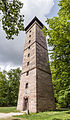
The observation tower

Wall remains

Walled up cellar entrance

Ventilation shaft of the basement

"Alte Veste" inn


literature
- Johann Kaspar Bundschuh : Old Vestung . In: Geographical Statistical-Topographical Lexicon of Franconia . tape 1 : A-egg . Verlag der Stettinische Buchhandlung, Ulm 1799, DNB 790364298 , OCLC 833753073 , Sp. 64 ( digitized version ).
- August Gebeßler : City and District of Fürth (= Bavarian Art Monuments . Volume 18 ). Deutscher Kunstverlag, Munich 1963, DNB 451450957 , p. 70 .
- Hanns Hubert Hofmann : Nuremberg-Fürth (= Historical Atlas of Bavaria, part Franconia I, 4). Commission for Bavarian State History, Munich 1954, DNB 452071224 , p. 98 ( digitized version ). Ibid. S. 235 ( digitized version ).
- Helmut Mahr: Wallenstein's camp. The Battle of the Alte Veste 1632 . Verlag Nürnberger Presse, Nuremberg 1980, ISBN 3-920701-57-7 .
- Helmut Mahr: Wallenstein before Nuremberg 1632 . Neustadt (Aisch) 1982.
- Wolfgang Wiessner: City and District of Fürth (= Historical Place Name Book of Bavaria, Middle Franconia . Volume 1 ). Commission for Bavarian State History, Munich 1963, DNB 455524629 , p. 4-6 .
Web links
- Old fortress as a 3D model in SketchUp's 3D warehouse
- 360 ° panorama
- Alte Veste in the location database of the Bavarian State Library Online . Bavarian State Library
- Alte Veste in the Topographia Franconiae of the University of Würzburg , accessed on September 21, 2019.
- Alte Veste in the historical directory of the association for computer genealogy
Individual evidence
- ↑ a b W. Wiessner, p. 4ff.
- ↑ Old fortress in the Bavaria Atlas
- ↑ Helmut Mahr: The old fortress until its destruction in 1388 . In: Fürther Heimatblätter . tape 30 , no. 1 . Association for local history research Alt-Fürth, Fürth 1980.
- ↑ Golo Mann: Wallenstein . S. Fischer Verlag GmbH Licensed edition of the German Book Association, Frankfurt Main 1971, p. 844-857 .
- ^ HH Hofmann, p. 98.
- ^ HH Hofmann, p. 235.
- ^ Walter Popp: The demolition of the observation tower on the Alte Veste in 1945 . In: Fürther Heimatblätter . tape 30 , no. 1 . Association for local history research Alt-Fürth, Fürth 1980.
- ↑ Only inhabited houses are given. In 1818 these were designated as fireplaces , in 1840 as houses and from 1885 to 1987 as residential buildings.
- ↑ Alphabetical index of all the localities contained in the Rezatkkreis according to its constitution by the newest organization: with indication of a. the tax districts, b. Judicial Districts, c. Rent offices in which they are located, then several other statistical notes . Ansbach 1818, p. 5 ( digitized version ).
- ↑ Eduard Vetter (Ed.): Statistical handbook and address book of Middle Franconia in the Kingdom of Bavaria . Self-published, Ansbach 1846, p. 211 ( digitized version ).
- ^ Joseph Heyberger, Chr. Schmitt, v. Wachter: Topographical-statistical manual of the Kingdom of Bavaria with an alphabetical local dictionary . In: K. Bayer. Statistical Bureau (Ed.): Bavaria. Regional and folklore of the Kingdom of Bavaria . tape 5 . Literary and artistic establishment of the JG Cotta'schen Buchhandlung, Munich 1867, Sp. 1029 , urn : nbn: de: bvb: 12-bsb10374496-4 ( digitized version ).
- ↑ Kgl. Statistical Bureau (ed.): Complete list of localities of the Kingdom of Bavaria. According to districts, administrative districts, court districts and municipalities, including parish, school and post office affiliation ... with an alphabetical general register containing the population according to the results of the census of December 1, 1875 . Adolf Ackermann, Munich 1877, 2nd section (population figures from 1871, cattle figures from 1873), Sp. 1194 , urn : nbn: de: bvb: 12-bsb00052489-4 ( digital copy ).
- ↑ K. Bayer. Statistical Bureau (Ed.): Localities directory of the Kingdom of Bavaria. According to government districts, administrative districts, ... then with an alphabetical register of locations, including the property and the responsible administrative district for each location. LIV. Issue of the contributions to the statistics of the Kingdom of Bavaria. Munich 1888, Section III, Sp. 1124 ( digitized version ).
- ↑ K. Bayer. Statistical Bureau (Ed.): Directory of localities of the Kingdom of Bavaria, with alphabetical register of places . LXV. Issue of the contributions to the statistics of the Kingdom of Bavaria. Munich 1904, Section II, Sp. 1192 ( digitized version ).
- ↑ Bavarian State Statistical Office (ed.): Localities directory for the Free State of Bavaria according to the census of June 16, 1925 and the territorial status of January 1, 1928 . Issue 109 of the articles on Bavaria's statistics. Munich 1928, Section II, Sp. 1230 ( digitized version ).
- ↑ Bavarian State Statistical Office (ed.): Official place directory for Bavaria - edited on the basis of the census of September 13, 1950 . Issue 169 of the articles on Bavaria's statistics. Munich 1952, DNB 453660975 , Section II, Sp. 1066 ( digitized version ).
- ↑ Bavarian State Statistical Office (ed.): Official city directory for Bavaria, territorial status on October 1, 1964 with statistical information from the 1961 census . Issue 260 of the articles on Bavaria's statistics. Munich 1964, DNB 453660959 , Section II, Sp. 782 ( digitized version ).
- ^ Bavarian State Statistical Office (ed.): Official place directory for Bavaria . Issue 335 of the articles on Bavaria's statistics. Munich 1973, DNB 740801384 , p. 174 ( digitized version ).
- ↑ Bavarian State Office for Statistics and Data Processing (Ed.): Official local directory for Bavaria, territorial status: May 25, 1987 . Issue 450 of the articles on Bavaria's statistics. Munich November 1991, DNB 94240937X , p. 338 ( digitized version ).

Old fortress | Apply | Banderbach | Bronnamberg | Corpse Village | Leichendorfermühle | Lind | Weiherhof | Vine ornaments | Wintersdorf | Wolfgangshof


Castles: Deberndorf Castle (dismissed) | Faberschloss | Loher Castle (exited) | Oedenreuth Castle (Old Castle) | Rossal Castle (exited)
Castles and ruins: Old Veste castle ruins | Cadolzburg | Roßal Castle (passed)
Tower hill castles (all gone): Burgstall Braunsbach | Bronnamberg Tower Hill | Buttendorf tower hill | Hausen Tower Hill | Langenzenn Tower Hill | Burgstall Puschendorf
Manor houses: Defersdorf manor house
Castle stables (lost, unknown castles): Burgstall Altenberg (Oberasbach) | Burgstall Burgfarrnbach | Burgstall Hiltmannsdorf | Burgstall Hochmilchling | Burgstall Seckendorf